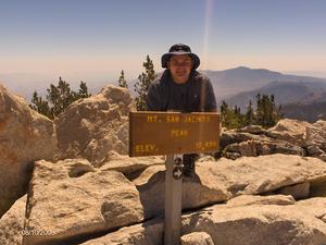
Clarifying the trail at the peak

General Palm Springs area.

Postby FIGHT ON » Tue Aug 19, 2008 6:42 pm

Perry wrote:Interesting point. There is a small sign on the peak signpost with the tram image and an arrow pointing towards the tram. If I remember right, it does point north of the peak shelter, which is a cross-country route back to Miller Saddle. If it pointed slightly south of the peak shelter, that would direct hikers back to the trail. But in the winter time, the cross country routes are more popular. Maybe a marker where the use trail makes a sharp turn...

Perry I don't remember seeing that on a sign up there. Is it on the summit sign? Can't remember seeing one. Do you have a picture of it? I want to see it.
I bet a lot of people go up the tram hearing that there is a "trail" up to the top of "San Jacinto Mountain". So off they go. Idiots, like me! The first time I went up there was from Humber Park with Charles. March 30th of last year. There was some snow on the trail from the San Jacinto Wilderness sign and on for about a mile. He had a gps that actually helped us find the trail on a few spots.:) There were footprints going in every direction and no trail. But after that it was free of any snow, clear and easy to follow as usual. I had studied the map enough before I went so I knew what to expect after the trail goes north to the hut. Had no problem at all because I knew it was generally north to the hut and west to the summit and reverse to get back. After being on top you know where north is. It's DOWN THERE! :lol: So I knew without a compass the way back. I was at least that prepared. The tourist tram idiots have no idea which way is which let alone which way is north or south. They just follow the trail, wherever the signs say to go. By the time they get up there they are dead tired. I've seen them. Zoom up the tram and get altitude sickness symptoms after walking 4 miles. Zombies. Completely disoriented. So close. Where's the Trail? And there's Hal. Kicking all the duck down. Lovely. This is a MAJOR peak and being dumped off at the tram which is so close to the summit is more than tempting. I bet more people summit this peak than any other so cal peak. Is that right? I bet it is. More than baldy I bet. so one sign? wow.

User avatar
FIGHT ON
 
Posts: 971
Joined: Fri Feb 08, 2008 1:23 pm
Location: Trousdale Parkway

Postby Rumpled » Wed Aug 20, 2008 2:16 am

Most of the trail signs I saw (Aug 10th) taking the standard route from the tram had a little tram emblem showing the way back to the tram; including the summit sign. =Summit hiking for dummies!

I think the summit sign was turned a different direction from some of the other pictures I've seen posted.

For the love of freakin' Pete - I just spent 20 minutes trying to embed pics from Flickr, maybe this link will work

http://www.flickr.com/photos/ucicoachjim/sets/72157606848652363/

OK, now I got it. I think Flickr is messed up - no .jpg so probably not recognized.

Image

Image

Image

Image
User avatar
Rumpled
 
Posts: 122
Joined: Fri Jul 11, 2008 1:15 am

Postby Rumpled » Wed Aug 20, 2008 2:23 am

And here's the duck leaving the main trail below Jean Mt heading to Tamarack, and the trail heading off in the background.

Image

Don't knock it over, it's just a duck.
User avatar
Rumpled
 
Posts: 122
Joined: Fri Jul 11, 2008 1:15 am

Postby simonov » Wed Aug 20, 2008 6:49 am


If you format your long links as I have above, it makes the threads a lot easier to read. Unless you enjoy horizontal scrolling.
Nunc est bibendum
User avatar
simonov
 
Posts: 72
Joined: Tue Nov 27, 2007 3:25 pm
Location: Reno, NV

Postby FIGHT ON » Wed Aug 20, 2008 7:29 am

simonov wrote:


If you format your long links as I have above, it makes the threads a lot easier to read. Unless you enjoy horizontal scrolling.

Thanks for telling me how, I fixed it. :D
User avatar
FIGHT ON
 
Posts: 971
Joined: Fri Feb 08, 2008 1:23 pm
Location: Trousdale Parkway

Trail Blazes

Postby Rick M » Thu Aug 21, 2008 3:16 pm

I recall when I started my wonderings, many trails had "blazes" a 3" square cut into the bark of trees about six to ten feet above the ground locally and in the Sierra. I wondered why some were so high off the ground until I started venturing out in the winter. Even in my environmental "hippie days" I was not against them, especially after several trips when a few feet of snow had fallen in an area I was unfamiliar and they made travel easy. In fact, I think they would actually benefit the land by keeping people on the trails instead of wondering around looking for the trail. This was in pre GPS days but I did have map/compass plus land nav experience. I have seen many people buy and carry these and NOT KNOW HOW TO USE THEM (including military and search and rescue people.

Recently, someone I talked to mentioned the fact that many of these peaks are in "wilderness areas" and people going into them should know what they're doing. While I agree with this, the number of people in SoCal, the size of the wilderness areas, and the ease of access give many people a false sense that a trip here will be a piece of cake. Those of you that have ventured into the back country wilderness in the Sierra, Trinity, and other states might also think that our "wilderness areas" here in SoCal are easy but a simple slip or wrong turn can change all that. I've thought about how those blazes of old would help with navigating the Skyline Trail (especially in the treed area in the winter) and with all the people losing their way on the other trails. Does this mean mark every tree? Not hardly but when standing at one tree one should be able to see the next blaze. Connecting the dots hiking? Maybe, I'm sure most would just stroll along following the well worn path but when covered by snow they sure would be nice. Reminds me of popular rock climbing areas since the use of chalk and bolts, follow the dots.
http://en.wikipedia.org/wiki/Trail_blaze

Rick
Rick M
 
Posts: 159
Joined: Tue Feb 19, 2008 8:59 pm

Re: Trail Blazes

Postby FIGHT ON » Thu Aug 21, 2008 4:34 pm

Rick M wrote:I recall when I started my wonderings, many trails had "blazes" a 3" square cut into the bark of trees about six to ten feet above the ground locally and in the Sierra. I wondered why some were so high off the ground until I started venturing out in the winter. Even in my environmental "hippie days" I was not against them, especially after several trips when a few feet of snow had fallen in an area I was unfamiliar and they made travel easy. In fact, I think they would actually benefit the land by keeping people on the trails instead of wondering around looking for the trail. This was in pre GPS days but I did have map/compass plus land nav experience. I have seen many people buy and carry these and NOT KNOW HOW TO USE THEM (including military and search and rescue people.

Recently, someone I talked to mentioned the fact that many of these peaks are in "wilderness areas" and people going into them should know what they're doing. While I agree with this, the number of people in SoCal, the size of the wilderness areas, and the ease of access give many people a false sense that a trip here will be a piece of cake. Those of you that have ventured into the back country wilderness in the Sierra, Trinity, and other states might also think that our "wilderness areas" here in SoCal are easy but a simple slip or wrong turn can change all that. I've thought about how those blazes of old would help with navigating the Skyline Trail (especially in the treed area in the winter) and with all the people losing their way on the other trails. Does this mean mark every tree? Not hardly but when standing at one tree one should be able to see the next blaze. Connecting the dots hiking? Maybe, I'm sure most would just stroll along following the well worn path but when covered by snow they sure would be nice. Reminds me of popular rock climbing areas since the use of chalk and bolts, follow the dots.
http://en.wikipedia.org/wiki/Trail_blaze
Rick


Rick
Pretty cool link.
Skyline and the tram up to the peak trail are completely different. To me the only similarities are that they both start somewhere and end somewhere. The main difference to me is that on the tram section more hikers are led to believe that they will be walking on a clear trail with clear signs the entire round trip. (Is there a sign anywhere that says the trail ends before you get to the peak?)
On Skyline there are a few signs at the beginning along with HUGE WARNINGS about the dangers if you keep going. And its not like a tram is dumping off loads of people right at the museum that want to hike around either. You can't find it on a map. I think people that plan to hike Skyline are more aware of the risks involved than the tram people are. I know I am repeating but on the tram section people believe they will be on a TRAIL WITH SIGNS THE WHOLE WAY UP AND BACK!!!!!! THAT'S WHAT THEY SEE FOR OVER FIVE MILES. AND ALL OF A SUDDEN NO TRAIL OR SIGNS!!!!! These tram people have no idea they will be tricked at the last minute. NOOOOO IDEA! Until they get off the trail. Some of you guys are used to using your sense of direction and experience from all the years you have been hiking. You know that some of these tram people have none of these senses. Just follow the trail one way up and then back the way they came up. I know it's their fault but why not put a sign at the beginning saying "THE TRAIL ENDS BEFORE THE PEAK. THE REST OF THE WAY YOU ARE ON YOUR OWN AND THERE IS NOT TRAIL OR MARKINGS" so they can decide before they go?
Either that or make the trail consistently easy to follow all the way up.

I like those rectangle marks chopped into the bark of trees idea. Except into the boulders past the shelter. Cut them with a diamond blade. Nice and neatly and just enough so you can follow them to the peak and back to the trail. But cut em in deep. Chisel it in. REAL DEEP! like 12 inches so they last a good,....long.... time.:lol: Try kickin those over! :lol:
User avatar
FIGHT ON
 
Posts: 971
Joined: Fri Feb 08, 2008 1:23 pm
Location: Trousdale Parkway

Postby asabat » Fri Aug 22, 2008 5:10 pm

It may be a trap. I recall some years ago being in a gas station in Independence when a gal walked in with a Rand McNally road atlas and a confused look on her face. She was trying to drive to Sequoia National Park, and the atlas clearly showed a road going to the park boundary. Of course, that road was Onion Valley Road, and it ends about 4 miles short of the park. Being from Germany, that's all the map she had. The point is, tourists do get bad information if they don't research in depth.

Maybe this is a dumb question, but since a wilderness permit is REQUIRED to proceed past Long Valley, maybe they could add information that the trail does NOT take you all the way to the top to the permit signature line? If someone feels strongly about this or better improving the trail to the true summit, maybe they could work with the rangers to make it happen. It sure won't happen just talking about it here.
asabat
 
Posts: 168
Joined: Wed Apr 11, 2007 7:47 pm

Postby FIGHT ON » Fri Aug 22, 2008 8:07 pm

They actually say there is a trail that goes all the way to the peak!
AND THEN THEY SAY TO STAY ON THE TRAILS!!!
CRAZY!

Palm Springs Aerial Tramway

http://www.pstramway.com/
http://www.pstramway.com/things.asp
http://www.pstramway.com/things/hiking-detail.asp
Hiking
Within the Mount San Jacinto State Park and Wilderness are 54 miles of hiking trails which should be sufficient to satisfy the appetite of the most avid outdoor enthusiast. Trails range from the awe-inspiring five and one-half mile trek to the 10,834 foot peak of San Jacinto to the just over one mile nature walk through picturesque Long Valley, located just behind the Tram's Mountain Station.


San Jacinto Peak: This strenuous three to four hour hike one way will take you to the second highest point in Southern California. On clear days it is reported that you can see Catalina Island or the glow from Las Vegas at night. (see guided nature walk)

For your comfort always wear sturdy closed toe shoes, layered comfortable clothing, hat and sunscreen. A light jacket in spring and early summer and for fall and winter a heavy jacket and gloves is a good idea, along with appropriate waterproof shoes. Water is only available in Long Valley and Round Valley. Bring your own water if you are traveling further. Stay on designated trails only.
User avatar
FIGHT ON
 
Posts: 971
Joined: Fri Feb 08, 2008 1:23 pm
Location: Trousdale Parkway

Postby Rick M » Sat Aug 23, 2008 12:28 am

FIGHT ON wrote:They actually say there is a trail that goes all the way to the peak!

...Trails range from the awe-inspiring five and one-half mile trek to the 10,834 foot peak of San Jacinto ...For your comfort always wear sturdy closed toe shoes, layered comfortable clothing, hat and sunscreen. A light jacket in spring and early summer and for fall and winter a heavy jacket and gloves is a good idea, along with appropriate waterproof shoes. Water is only available in Long Valley and Round Valley. Bring your own water if you are traveling further.
Stay on designated trails only.

Great example Fight On.
Asabat has a point; visitors need to research where/how they are going and for many that research might be the site Fight On refers to. I know when I was just starting and going to new places I would frequently simply read the brochure given out at the entrance kiosk. I really like what it says for in the winter "...a heavy jacket and gloves is a good idea along with appropriate waterproof shoes" I hope they don't run into any ice! I wonder what Ellen might have to say about this.

I don't think the sign is a good alternative for not doing something more substantial to the trail at the top but given the current situation, it would be better than nothing. As has been pointed out, there is a tiny symbol on the sign pointing in the direction of the trail (or tram?) but for the inexperienced, after stepping on, around, over some of the large rocks up there, it would be easy for them to wonder around till they miss the trail. I don't know if the agency with jurisdiction would be interested in fixing the trail, as it requires time, energy, and money on their part. Perhaps a volunteer group that does trail maintenance in the area (Sierra Club?) as Asabat mentioned.

The blaze idea is for the times when snows cover the trail. Something that might be useful for the "54 miles of trails" and the treed area on the Skyline where so many get off route and into trouble in the winter. I've had my share of planned x-country wilderness experiences and I know that is not what many coming up the tram are looking to do in hiking up the trail to the peak or other trails, this is what trail maintenance is for. I've had many good times working on trail work "parties" with different organizations. One draw back is that all you can usually say is "We did a whole mile of trail in 6 hours"
Rick M
 
Posts: 159
Joined: Tue Feb 19, 2008 8:59 pm

PreviousNext

Return to Mt. San Jacinto & Santa Rosa Mountains

Who is online

Users browsing this forum: Baidu [Spider] and 33 guests