Hiking noobs summit Mt San Jacinto

General Palm Springs area.

Hiking noobs summit Mt San Jacinto

Postby simonov » Sun Aug 17, 2008 11:40 am

A month or so ago, my sister called me to say she wanted to do some hiking with me. Not knowing her capabilities, I took her up the Sam Merrill Trail to Echo Mountain above Altadena, only 2.5 miles each way but pretty steep. She handled that much better than expected, so I decided she needed to experience what a summit felt like, as soon as possible.

So far as I'm concerned, the easiest summit in SoCal is Mt San Jacinto from the Tram, so I arranged to pick her up in LA at 6:00am on Saturday and try to catch the first tram up. My niece also decided to come along.

All they needed for this hike, I suggested, were some decent shoes. Personally, I like to encase my tender feet in steel-shanked, lug soled mountaineering boots for high country hikes like this one, never mind the weight, but I told my sister to at least get some trail hikers at REI or something. As it happened, she didn't have time to pick up anything, so she and my niece did the climb in ordinary tennis shoes. This wasn't much of a problem going up, but they paid dearly during the long, long, long trip down.

My sister and niece had never before been on the Palm Springs Aerial Tramway, and indeed, like most urban SoCal natives, they had no idea there was anything like Mt San Jacinto (or San Gorgonio, or even the San Gabriels) in the area. The ride in the tram was an early highlight of the trip:

Image

They were very impressed with the scenery. Lush meadows and thick forests of lodgepole pine are not what folks, even natives, usually associate with Southern California, unless you've actually been up there to experience them. And then there are the views above Wellman Divide . . .

Image

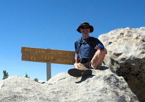
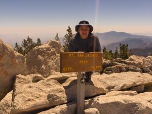
The hike up was easy and uneventful for all of us. We started at about 9:00 and arrived at the summit just before noon.

Image

We had lunch on the summit and were up there for about 45 minutes or so. While we were there, I think there were only about a dozen or so people up there with us, though a party of about five or six arrived just as we started down. However, as we proceeded back down the trail, we must have passed between 60 and 100 people heading up. "This," I told my sister after we passed one of several parties of about ten college-age Asian-American kids, "is why we get up on the mountain as early as possible, among other reasons." The summit of Mt San Jacinto simply doesn't have space for all the people we saw heading up there while we were coming down. I can't imagine what it must have been like.

As usual, the walk down seemed a lot longer than the walk up. My sister and niece complained bitterly about this. I confessed I hated return hikes as well, and they do indeed always seem longer, and they also hurt my feet far more than the hike up. But it comes with the territory. Their misery was compounded, I believe, by their substandard footwear. My sister said she will definitely be getting some boots before the next hike.

Image

In the morning as we set out down the long ramp from the tram building, I warned my sister and niece that ramp would a final unpleasant challenge at the end of the hike. Indeed, as we puffed up the ramp in the afternoon, we agreed it was a dirty trick to have put it there like that, and my niece wanted to know where to write to insist an escalator be installed for tired hikers (and maybe for all the overweight people we saw strolling around the tram area when we arrived back at the station).

But in the end everyone enjoyed the hike and was pleased with how well they did. I promised more summits to come, but we will be working our way up to tougher ones like San Gorgonio and Mt Baldy (when I mentioned the possibility of return via Baldy Notch and the chairlift, there was a great deal of enthusiasm for a Mt Baldy hike). Once everyone gets better shoes, we'll probably tackle Mt San Jacinto again from Humber Park or Marion Mountain.

More pics here.
Nunc est bibendum
User avatar
simonov
 
Posts: 72
Joined: Tue Nov 27, 2007 3:25 pm
Location: Reno, NV

Postby zippetydude » Sun Aug 17, 2008 1:36 pm

Thanks for a cool post somonov. Congratulations to your companions (and you of course) on a job well done!

Sorry to hear about their shoe situation. I'm sure REI or BIG 5 or Sport Chalet or Sport Authority...or some fine retail establishment can remedy the problem.

Now, what's this about not liking return trips?! I used to feel that way, but I've had something of a change of heart.

What happened was this: I was headed back down San Gorgonio a number of years ago, thinking about how many miles I had left (ugh!).

Then I looked out at the valley, far below, where I live, with smog, and traffic, and a garage waiting to be cleaned...and I thunk, "Rats! I only get a couple more hours up here. I love it up here." Now, (as long as I'm heading downhill!) the hike down seems to be part of the joy, not just another boring return hike. Try that next hike, see if it helps.

Sorry, I don't have any ideas for you when the return hike is uphill. I went down to Caramba last year, took a nice cool dip in the stream, then suffered in the sun all the way back to the tram. Can't say I savored that return trip. Still workin' on an angle for that one.

Incidentally, I think it's cool how you've introduced two people to the wilderness in such a great way. Great job.

z
User avatar
zippetydude
 
Posts: 2751
Joined: Tue May 09, 2006 5:40 am

Postby FIGHT ON » Sun Aug 17, 2008 5:03 pm

:D YOU HOOKED EM SIMONOV! :D
User avatar
FIGHT ON
 
Posts: 971
Joined: Fri Feb 08, 2008 1:23 pm
Location: Trousdale Parkway

New Sign

Postby reelds9 » Sun Aug 17, 2008 6:08 pm

Sounds like a fun trip. It doesn't look like I'll get a San Jacinto hike in this year, but I was glad to hike Wheeler Peak. Also, it looks like they replaced the broken sign at the summit, which is nice.
User avatar
reelds9
 
Posts: 6
Joined: Wed Jun 27, 2007 7:34 pm
Location: San Diego

Postby kgw » Mon Aug 18, 2008 8:15 am

Those faces tell all 8) Good footwear and good socks make a world of difference.
kgw
 
Posts: 11
Joined: Sun Jul 13, 2008 4:09 pm
Location: Long Beach, CA

Re: New Sign

Postby Hikin_Jim » Tue Aug 26, 2008 12:47 pm

reelds9 wrote:Sounds like a fun trip. It doesn't look like I'll get a San Jacinto hike in this year, but I was glad to hike Wheeler Peak. Also, it looks like they replaced the broken sign at the summit, which is nice.
The new sign kind of cracks me up. It says "Mt. San Jacinto Peak." :lol:

"Mt. San Jacinto" is the more common name, but the official USGS name is "San Jacinto Peak." Well, I guess if you can't make up your mind whether it's Mt. San Jacinto or San Jacinto Peak, you'd wind up with the sign now up there. :D
Last edited by Hikin_Jim on Tue Aug 26, 2008 4:46 pm, edited 1 time in total.
Backpacking stove reviews and information:  Adventures In Stoving
Personal hiking blog: Hikin' Jim's Blog
User avatar
Hikin_Jim
 
Posts: 4958
Joined: Mon Oct 30, 2006 9:12 pm
Location: Orange County, CA

Postby Rumpled » Tue Aug 26, 2008 3:20 pm

I didn't get a pic of it, but on the back of the sign was an engraving false start - it was about two words or so. I couldn't tell the error (low O2 maybe); but someone turned it over and tried again.
User avatar
Rumpled
 
Posts: 122
Joined: Fri Jul 11, 2008 1:15 am

Re: New Sign

Postby phydeux » Wed Aug 27, 2008 7:41 pm

Hikin_Jim wrote: The new sign kind of cracks me up. It says "Mt. San Jacinto Peak." :lol:


The sign was probably made by the State's Department of Redundancy Department.
3 of the 5 voices in my head are telling me to "Go for it!"
User avatar
phydeux
 
Posts: 348
Joined: Sat May 13, 2006 5:32 pm
Location: Orange County, CA.

Re: New Sign

Postby FIGHT ON » Wed Aug 27, 2008 8:06 pm

phydeux wrote:The sign was probably made by the State's Department of Redundancy Department.

Think positive. Be happy they didn't put an arrow on it. :lol:
User avatar
FIGHT ON
 
Posts: 971
Joined: Fri Feb 08, 2008 1:23 pm
Location: Trousdale Parkway

Postby Perry » Wed Aug 27, 2008 9:02 pm

Isn't that the same as saying it's the top of the mountain? The picnic benches on the Museum Trail are on Mt. San Jacinto, but definitely not the peak.

San Jacinto:
http://en.wikipedia.org/wiki/Saint_Hyacinth_of_Poland
"And he knows those computers better than anybody, all those computers, those vote-counting computers. And we ended up winning Pennsylvania like in a landslide, so, it was pretty good, it was pretty good, so thank you to Elon!"
-Donald Trump
User avatar
Perry
Site Admin
 
Posts: 1525
Joined: Mon May 08, 2006 6:01 pm
Location: Palm Springs, CA

Next

Return to Mt. San Jacinto & Santa Rosa Mountains

Who is online

Users browsing this forum: Baidu [Spider] and 13 guests