
Mt. San Jacinto Outdoor Recreation
Hiking, Climbing, Camping, Trail Running, Snowshoeing...
Joyce Peak
5 posts
• Page 1 of 1
Joyce Peak
![]() by RMRUpete » Sun May 25, 2025 3:01 pm
by RMRUpete » Sun May 25, 2025 3:01 pm
Have done this peak 4 times, this is the first time in a while. It now has a register put in May 28, 2018. Only about a dozen people have signed in up to May 23, 2025. As an out of shape 76 year old it took us 6 1/2 hours to hike up Marion Mt Trail, then to Bud Springs, Mt St Ellen, Joyce Peak, Bed Springs, and down to Deer Springs Trail and then back to Marion Mt Trail head. Her are some photo's for Hikin_Jim since the Peak got the name from his Daughter.
- Attachments
-
- Small Can bottom right of photo below peak
- Joyce-Peak-03.jpg (85.36 KiB) Viewed 42719 times
-
- First sing in I assume put the register here.
- Joyce-Peak-02.jpg (45.08 KiB) Viewed 42719 times
-
- Cover elevation and name
- Joyce-Peak-01.jpg (51.19 KiB) Viewed 42719 times
How can I be lost if I don't care where I am?
RMRU member 50 years
RMRU member 50 years
-
RMRUpete - Posts: 34
- Joined: Fri May 14, 2010 9:26 am
Re: Joyce Peak
![]() by guest » Mon May 26, 2025 8:26 am
by guest » Mon May 26, 2025 8:26 am
That sounds like an interesting, and decently tough trek Pete. I do like that area on the ridge, which is somewhat flat with boulders and trees spread out enough for cross country travel. I'll have to check it out the next time on in the San Jacinto's, (Joyce & Ellen, two tough chicks, with just a "few" years between them, ha), scott
- guest
- Posts: 807
- Joined: Fri Oct 27, 2006 3:27 pm
Re: Joyce Peak
![]() by Hikin_Jim » Wed May 28, 2025 1:07 pm
by Hikin_Jim » Wed May 28, 2025 1:07 pm
Pete:
How funny! I was atop Joyce Peak on Sunday morning (May 25). What day were you there?
I've never really found Bud Springs, which I gather is somewhere on the middle fork of Stone Creek. Map - Forks of Stone Creek. One time I descended the middle fork of Stone Creek from the summit of Marion Mountain. I found Stone Creek to be aptly named -- it had huge boulders in it. I found descending that creek to be a lot of work and decided not to attempt it ever again.
Bed Springs and Deer Springs are far more easily identified and located. See photos, below.
Scott:
Ever since I first discovered the "summit plateau" of the San Jacintos (bounded by Folly, San Jacinto, and Miller on the north and Marion on the south) in the 1990s while on a Sierra Club Hundred Peaks Section hike, I've been in love with the area. It's, in my opinion, the most Sierra like country in all of Southern California, and, as you say, very navigable. There's a very old survey section corner up there that I found on one of my hikes. All sorts of interesting nooks and crannies and interesting spots up there.
A few pics from my most recent endeavor:
How funny! I was atop Joyce Peak on Sunday morning (May 25). What day were you there?
I've never really found Bud Springs, which I gather is somewhere on the middle fork of Stone Creek. Map - Forks of Stone Creek. One time I descended the middle fork of Stone Creek from the summit of Marion Mountain. I found Stone Creek to be aptly named -- it had huge boulders in it. I found descending that creek to be a lot of work and decided not to attempt it ever again.
Bed Springs and Deer Springs are far more easily identified and located. See photos, below.
Scott:
I do like that area on the ridge, which is somewhat flat with boulders and trees spread out enough for cross country travel.
Ever since I first discovered the "summit plateau" of the San Jacintos (bounded by Folly, San Jacinto, and Miller on the north and Marion on the south) in the 1990s while on a Sierra Club Hundred Peaks Section hike, I've been in love with the area. It's, in my opinion, the most Sierra like country in all of Southern California, and, as you say, very navigable. There's a very old survey section corner up there that I found on one of my hikes. All sorts of interesting nooks and crannies and interesting spots up there.
- Heading cross country near Joyce Pk
A few pics from my most recent endeavor:
- Joyce Peak Summit Register - Title Page
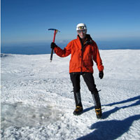
- Random hiker atop Joyce Peak 5/25/2025
- Looking out at Saddleback Mountain from Joyce Pk
- Looking down from Joyce Pk toward Hwy 243
- Deer Springs (the actual source, not where it crosses the trail)
- Bed Springs
Backpacking stove reviews and information: Adventures In Stoving
Personal hiking blog: Hikin' Jim's Blog
Personal hiking blog: Hikin' Jim's Blog
-

Hikin_Jim - Posts: 4958
- Joined: Mon Oct 30, 2006 9:12 pm
- Location: Orange County, CA
Re: Joyce Peak
![]() by guest » Thu May 29, 2025 9:31 am
by guest » Thu May 29, 2025 9:31 am
Great pics Jim, so many of the magical places in SoCal and the San Jacinto's are off trail. I know of a spot on that east side of Miller ridge, where there are 3 "corners" marked on trees w notches, (maybe one metal cap in rock to ID the spot, which I was told by BLM surveyor were placed when a rock wasn't available, to designate the actual spot, corner).
I've heard that large Boyscout troops would camp on that flat area, then hike to the summit, use reflectors or mirrors to shine to other SoCal peaks, where other scouts were doing the same thing.
And, isn't there an amazing story of a scout wondering down the north side of San Jac and somehow making it all the way down!? scott
- guest
- Posts: 807
- Joined: Fri Oct 27, 2006 3:27 pm
Re: Joyce Peak
![]() by Hikin_Jim » Thu May 29, 2025 11:23 am
by Hikin_Jim » Thu May 29, 2025 11:23 am
Interesting. I'm not sure exactly what type of survey marker you saw; there are a couple of possibilities.
There is a section corner over by Miller, the SE corner of Section 16, Township 4 South, Range 3 East, San Bernardino Baseline & Meridian, but that's down off the ridge a ways in very steep country. Maybe you saw that, but it would be hard to get to. Another marker that the surveyors use is not a full section corner but quarter section corner marker. If you were to divide up a standard mile square survey section into four equal square lots, the quarters would have a quarter section corner a 1/2 mile from the full section corner. In this case, a quarter corner would be very close to Miller Saddle. That could be what you saw, but I'm not sure. The survey section lines on a USGS topo are not exact. They are not an official survey plat; they're an approximation. It's possible that the full section corner is more accessible than one might think based on the topo map. I'll have to look around next time I'm there.
For future fun, there's a section corner that's fairly easy to find -- I saw it from a distance -- in the flatish area ENE of Joyce Peak, SW of Jean Peak. It's a stack of rocks with carvings in the trees around it. This is the SW corner of section 21, T4S, R3E, SBBM, where it meets sections 20, 29, and 28. One mile north of there, SW of Little Folly Peak (between Folly Peak and San Jacinto Peak) are two section corners. I say two because there's an off set where they had to "fudge" the section lines for whatever reason. The fudge is only about 200 feet, but they would normally have two section corner monuments in such a case.
Fascinating what you might find out there. One never knows.
HJ
- Trail Crew Gear Stash
Backpacking stove reviews and information: Adventures In Stoving
Personal hiking blog: Hikin' Jim's Blog
Personal hiking blog: Hikin' Jim's Blog
-
Hikin_Jim - Posts: 4958
- Joined: Mon Oct 30, 2006 9:12 pm
- Location: Orange County, CA
5 posts
• Page 1 of 1
Return to Mt. San Jacinto & Santa Rosa Mountains
Who is online
Users browsing this forum: No registered users and 9 guests