Hi aeolian,
If you read everything on the OtherHand website about Bill Ewasko, most of your questions will be answered. If you read through this 86 page thread, the rest will be answered. You will also encounter a lot of raw speculation. Skip through that and concentrate on posts with actual evidence. Look for posts by OtherHand.
Consider the case of Canadian hiker Paul Miller who went missing off an easy Joshua Tree trail in July 2018. His remains were not found until December 2020. JT can be a tough place.

Mt. San Jacinto Outdoor Recreation
Hiking, Climbing, Camping, Trail Running, Snowshoeing...
Story of missing hiker in Joshua Tree NP
Re: Story of missing hiker in Joshua Tree NP
![]() by RichardK » Tue Oct 26, 2021 8:31 am
by RichardK » Tue Oct 26, 2021 8:31 am
- RichardK
- Posts: 181
- Joined: Tue Jan 22, 2013 10:52 pm
Re: Story of missing hiker in Joshua Tree NP
![]() by aeolian » Tue Oct 26, 2021 4:43 pm
by aeolian » Tue Oct 26, 2021 4:43 pm
In my home area (bay area, so wetter than JTree), I've watched a whole pile of cow disappear in two years but for parts of the largest bones. Somebody likely knows how long a bighorn skeleton lasts in JTree. OtherHands finds a lot of them, does he revisit the same one years later?
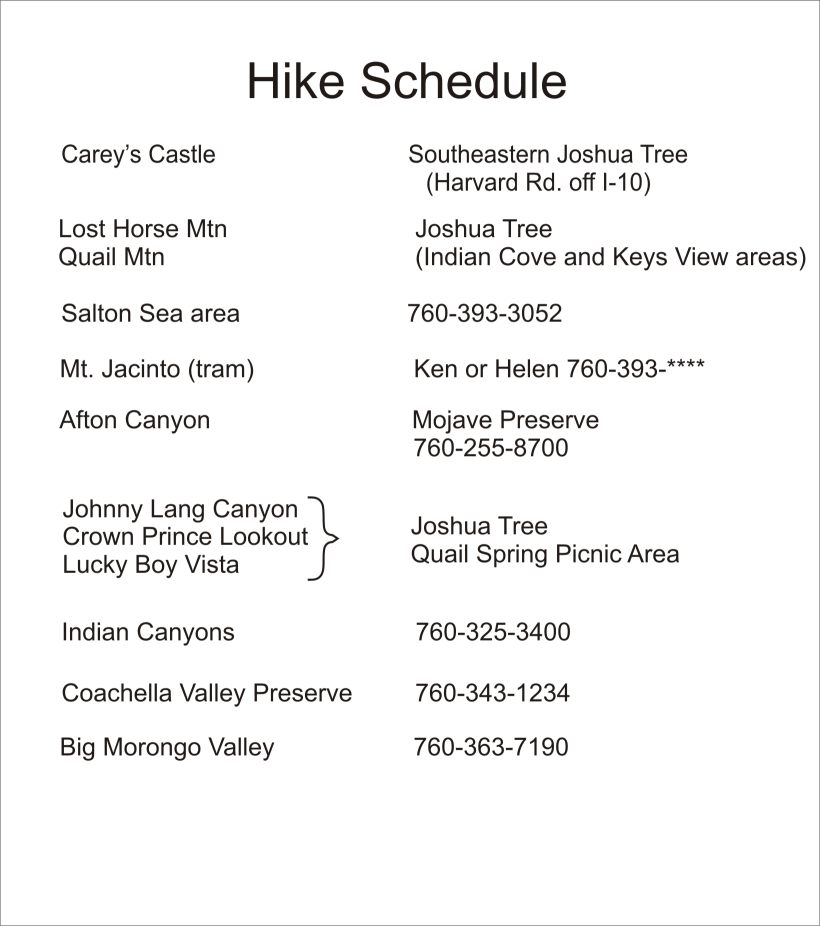
The itinerary https://www.otherhand.org/wp-content/uploads/2012/04/Ewasko-itinerary.jpg is just a list of places for each day. Hard to tell what Bill's activity plan was. I did find Bill's height/weight and a photo. He doesn't 'look' like or match the BMI of a typical lean long distance guy, so summitting Quail was a likely plan. OTOH, if the itinerary means summit Lost Horse Mountain plus Quail Mountain that looks like 17+ miles. A guy who covers 17 miles in a day could get anywhere.
JT37 gets at my kind of thinking. With map and compass navigation (or less), I've found it's easy to get off trail. The Juniper Flats trail looks like pretty generic terrain (from photos) without much for distinct features. No prominent peak (Quail?) or ridgeline or canyon. Easy to get off track in those washes and hills and would be difficult to reorient once lost. Do we even know he had a map? E.g. I might try Quail Mountain with no map, likely without a compass. If he got himself lost anywhere southwest of the CR&HT, I could reasonably put him anywhere between hwy 62 and I10 by Sunday (or later with water). How much more can a human travel after 2 days no water?
A lot of people have surely done a pretty thorough job searching. I'm really impressed by the organization and dedication.
eta: I see Mendoza hiked Stubbe Springs. Page 10 https://www.otherhand.org/wp-content/uploads/2012/04/FOIA-Extract-Narrative.pdf
eta2: I found this KarmaFrog blog that answers many of my questions. https://ijustdisappear.com/wp/2018/05/22/unsolved-mysteries/ Bill did have at least a 12 pack of water in the car, we don't know about maps/compass, there's no detailed itinerary, a human can travel a long way for several days with no water. (and there's conspiracy theories, yay!)
- aeolian
- Posts: 9
- Joined: Sun Oct 24, 2021 12:59 am
Re: Story of missing hiker in Joshua Tree NP
![]() by jdclifford » Wed Oct 27, 2021 12:33 pm
by jdclifford » Wed Oct 27, 2021 12:33 pm
I'm glad you found some of the other information, aeolian. I had time to come on here because my work let me off the rest of the week so that the swelling could go down in my left leg. ORIF surgery on broken tibia and fibula on Friday...looks like the 2020-21 JT search season will most likely be a wash for me. Bummer.
I'm not sure if all of this information was covered on Adam's site that you found, but this is information I found here and there on OtherHand:
He was 66 years old, but it seemed that he was a regular hiker and avid jogger. He was also a Vietnam vet who wasn't afraid of a tough hike. It was in late June and in the 90s at Juniper Flats the day he went missing. His initial plans were to hike to Cary's Castle which is in the hotter southern section of JT, so he certainly wasn't risk-averse. He had loved the desert Southwest and had hiked there in the past, but it is easy to forget how much different it is hiking here. I went on a hiking roadtrip for two weeks 3 years ago where I backpacked in Arkansas, Michigan, West Virginia, and Kentucky. The next weekend I was back in New Mexico and went backpacking here. I underestimated how much water I would need, and I live here year-round. Bill, however, was believed to be only carrying two 12-ounce bottles of water. His clothing was not known and I was wrong about him having black boots (though he very well may have). It was believed that he had a black backpack. I would imagine that a backpack would be tattered, yet still visibly out there after over 11 years. Bill was also, according to his fiance, a compass and map kind of guy. The make of his cellphone is also not known but it wasn't a smartphone.
It's my belief at this point he was either injured or became overwhelmed by the heat and that he secreted himself for maximum shade within some rocks. Hopefully someone finds him this cool season. If not, I shall be back.
- jdclifford
- Posts: 58
- Joined: Sun Jan 19, 2020 11:48 pm
Re: Story of missing hiker in Joshua Tree NP
![]() by aeolian » Thu Oct 28, 2021 2:59 pm
by aeolian » Thu Oct 28, 2021 2:59 pm
Good luck healing your leg!
Thanks for the info. While I'd like to speculate wildly, I feel I owe it to people to read more of this thread first. Not sure I'm up for the slog. Anyway, my thinking is the most likely happening is Bill got lost (anywhere west of the Stubbe Spring - Quail Mountain line), and was uninjured and alive until exposure got him. What's surprising is that a healthy avid desert hiker doesn't pop out of that wilderness within a week or just days. Ten "crow flies" miles in most directions from Juniper Flats puts him on a paved road or in a backyard, likely with city glow for guidance at night.
If he really carried only 24oz water, that suggests he planned something like - over drink at the car, jog to Juniper Flats, summit Quail and return to car in 3+ hours a little thirsty. Going light on water suggests going light on all else too. Maybe sneakers instead of boots, no map, no compass, no 10 essentials, maybe no pack, etc. Maybe a favorite pocket knife (though TSA probably took it), but otherwise no survival gear but wits. I would do this, though I might carry a bit more water if I used a pack. Once lost and evening comes, if he's got his wits, he'll be thinking GF will report him missing, and rescue will looking for him the next day. I think chollas are a PITA, and would tend not to hike at night unless I wore boots. It's not cold enough to be dangerous. The heat is probably manageable. So mostly stay put until rescue comes or put minor effort into finding the trail or water. Try any desert survival tricks he's heard - move only at night, cactus or yucca for water/food, sand burial for heat protection, drink pee, catch a lizard/snake/bug, etc. Climb a high point and try the phone (does he know to leave it on to send a text?). 3-blast the whistle if he has one. Smoky fire if he has a lighter. Check (or dig) a low point or canyon-side for water (any geology background?). Were there T-storms in prior week? Does he eat the Mormon Tea? Intentionally or unaware, that could give surprising endurance.
By Saturday morning (or evening) there's no sign of rescue. Now he's gonna self-rescue. We think he looked at maps, so even if he doesn't carry one, he may know downhill leads to safety. He may also know his boundaries - the park road, CA62, I10, and maybe that southeast is a bad direction. Without the cell phone ping (and not visiting the area), I'd look in the drainage southwest of Juniper Flat (also drains Stubbe Spring), or maybe the East Deception Canyon drainage (especially if i believe the 10 mile ping). With the cellphone ping, it's harder to argue where Bill pinged from without finding the Covington Flats. And why if he found the Covingtons, he wasn't found. Washes have no water and no shade, so that would be a reason to try a canyon instead. Although if there were people in the Covingtons, seems hard to make a 10-mile cellphone ping from that area and not see a car there (unless he passed through at night, or couldn't see distance).
I see Tom thinks steep sand makes slow travel. If one lets go of firm footing and embraces the dirt glissade, this terrain can make for fast fun easy travel.
That's my thoughts as someone who likes to hike, has been disoriented a few times, seen others confused at obvious spots (at a junction with trail signs and GPS and map and compass), and has hiked/backpacked in deserts. As an internet snipe hunter here who's never been in this specific area, I expect my insights lead you to Bill tomorrow . Probably I just speculated what's already been said 10 times in this thread
  Thanks for keeping the thread up.
Thanks for the info. While I'd like to speculate wildly, I feel I owe it to people to read more of this thread first. Not sure I'm up for the slog. Anyway, my thinking is the most likely happening is Bill got lost (anywhere west of the Stubbe Spring - Quail Mountain line), and was uninjured and alive until exposure got him. What's surprising is that a healthy avid desert hiker doesn't pop out of that wilderness within a week or just days. Ten "crow flies" miles in most directions from Juniper Flats puts him on a paved road or in a backyard, likely with city glow for guidance at night.
If he really carried only 24oz water, that suggests he planned something like - over drink at the car, jog to Juniper Flats, summit Quail and return to car in 3+ hours a little thirsty. Going light on water suggests going light on all else too. Maybe sneakers instead of boots, no map, no compass, no 10 essentials, maybe no pack, etc. Maybe a favorite pocket knife (though TSA probably took it), but otherwise no survival gear but wits. I would do this, though I might carry a bit more water if I used a pack. Once lost and evening comes, if he's got his wits, he'll be thinking GF will report him missing, and rescue will looking for him the next day. I think chollas are a PITA, and would tend not to hike at night unless I wore boots. It's not cold enough to be dangerous. The heat is probably manageable. So mostly stay put until rescue comes or put minor effort into finding the trail or water. Try any desert survival tricks he's heard - move only at night, cactus or yucca for water/food, sand burial for heat protection, drink pee, catch a lizard/snake/bug, etc. Climb a high point and try the phone (does he know to leave it on to send a text?). 3-blast the whistle if he has one. Smoky fire if he has a lighter. Check (or dig) a low point or canyon-side for water (any geology background?). Were there T-storms in prior week? Does he eat the Mormon Tea? Intentionally or unaware, that could give surprising endurance.
By Saturday morning (or evening) there's no sign of rescue. Now he's gonna self-rescue. We think he looked at maps, so even if he doesn't carry one, he may know downhill leads to safety. He may also know his boundaries - the park road, CA62, I10, and maybe that southeast is a bad direction. Without the cell phone ping (and not visiting the area), I'd look in the drainage southwest of Juniper Flat (also drains Stubbe Spring), or maybe the East Deception Canyon drainage (especially if i believe the 10 mile ping). With the cellphone ping, it's harder to argue where Bill pinged from without finding the Covington Flats. And why if he found the Covingtons, he wasn't found. Washes have no water and no shade, so that would be a reason to try a canyon instead. Although if there were people in the Covingtons, seems hard to make a 10-mile cellphone ping from that area and not see a car there (unless he passed through at night, or couldn't see distance).
I see Tom thinks steep sand makes slow travel. If one lets go of firm footing and embraces the dirt glissade, this terrain can make for fast fun easy travel.
That's my thoughts as someone who likes to hike, has been disoriented a few times, seen others confused at obvious spots (at a junction with trail signs and GPS and map and compass), and has hiked/backpacked in deserts. As an internet snipe hunter here who's never been in this specific area, I expect my insights lead you to Bill tomorrow
- aeolian
- Posts: 9
- Joined: Sun Oct 24, 2021 12:59 am
Re: Story of missing hiker in Joshua Tree NP
![]() by bretpct » Mon Nov 08, 2021 12:22 pm
by bretpct » Mon Nov 08, 2021 12:22 pm
Went on a hike this past weekend. I wanted to check out a couple of small hills near Juniper Flats Rd, just under 2 miles from the parking area. My reasons for looking here were that if Bill was trying to get a cell signal, these hills are very near the trail and very easy to climb. I took extra time to check out several shade providing trees and rocks. Didn't find much of anything except an old can, and my normal haul of several Mylar balloons.
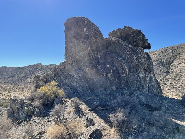
Shady rock
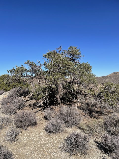
Shady pine
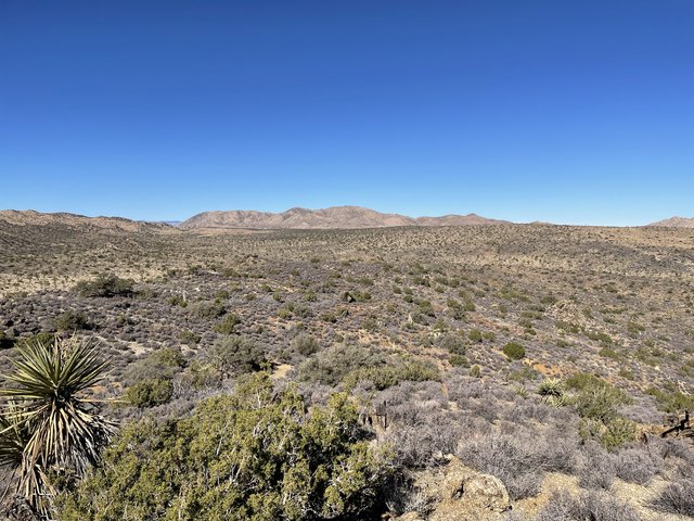
View toward Quail Mtn.
One thing that surprised me was that even about 50ft off the valley floor, how invisible Juniper Flats Rd and the CRHT were. Both are in this picture.

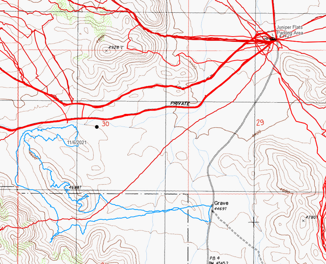
Here's the hike on a map in light blue:
Mylar balloons collected: 5
You can download the track off this Caltopo map where I'm storing my Ewasko hikes at the moment.
EDIT: I want to add that I believe Perry's caltopo map to be the most complete one I have found. https://caltopo.com/m/3LDM
Shady rock
Shady pine
View toward Quail Mtn.
One thing that surprised me was that even about 50ft off the valley floor, how invisible Juniper Flats Rd and the CRHT were. Both are in this picture.
Here's the hike on a map in light blue:
Mylar balloons collected: 5
You can download the track off this Caltopo map where I'm storing my Ewasko hikes at the moment.
EDIT: I want to add that I believe Perry's caltopo map to be the most complete one I have found. https://caltopo.com/m/3LDM
- bretpct
- Posts: 65
- Joined: Mon Feb 13, 2017 2:40 pm
Re: Story of missing hiker in Joshua Tree NP
![]() by jdclifford » Tue Nov 09, 2021 10:30 pm
by jdclifford » Tue Nov 09, 2021 10:30 pm
Thanks for posting those, Bret! I had thrown some of my theories Ric's way in an email a ways back and was wondering about the area just beyond the southermost part of your route (climbing up and beyond those peaks). Though fairly close to the road, I don't believe it's an incredibly well-traveled area. And even if it did get people back there every now and then, it's an incredibly rocky area. I actually climbed up there once (the one and only time I was in that area) and felt almost overwhelmed by how many places you could hide in the shade there were. I did not go beyond climbing the peak and walking just a bit on the ridgeline. I think I agreed with Ric that it might be a bit far from the supposed ping distance, but it would suprise me none if he ends up being found closer to the Juniper Flats trailhead than the ping would suggest. It would make more sense that he would be closer when he was only (supposedly) carrying two 12 oz bottles of water in 90+ degree weather.
I'm still hoping to get back out there again before it gets too hot (March up until break of dawn hikes in early May), but it very well could be a year until it's physically possible for a decent hike when it's not too hot. If it's before the summer, it will only be hikes with minimal steep elevation gain. I fractured all three malleoli in my left ankle, meaning zero support. My foot was literally dangling from my leg when I lifted it after breaking it. Apparently trimalleolar fractures are the least common ankle fractures, but I was lucky to not completely tear any ligaments or tendons. I'll post a pic from my rescue via horse. My unseen ankle is isolated and wrapped along the flank. I'm allergic and had never rode horseback, so, on the bright side, I was able to feel like a cowboy for once in my life lol
I have a few big research papers to finish writing in this last month of this crazy semester, but I definitely plan to post my routes on here right after the semester ends. Feel free to shoot me a message if you'd like the routes in the meantime, because I already have a handle on how to send the files separately in an email.
- Attachments
-
- jdclifford
- Posts: 58
- Joined: Sun Jan 19, 2020 11:48 pm
Re: Story of missing hiker in Joshua Tree NP
![]() by bretpct » Mon Nov 15, 2021 8:34 pm
by bretpct » Mon Nov 15, 2021 8:34 pm
Went back to JT this past weekend. That's two in a row-- I'm on a roll! This trip, I continued my current working theory that Bill sought high ground near the trail, ping distance notwithstanding.
I chose to check out some hills near the CRHT in Lower Covington. I arrived at the Upper Covington trailhead Saturday around 10:30 AM and found an over-full parking lot, including about six Subaru Outbacks. I parked my car in the roundabout trying not to block the road, and ended up scratching my dang car against a rock. The travel to the peaks nearest the trail involved some treacherous rock hopping, which I was not thrilled to be doing (I always hike with a PLB). At the top of one of these boulder jumbles was a what I'll call a "pocket". A little bowl with a flat bottom, surrounded on all sides by rocks. If Bill sought shelter in one of these formations, who knows if he'll ever be found. But it was a beautiful day to be outside.
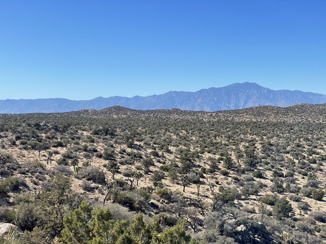
Venerable Mt. San J
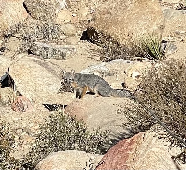
Urocyon cinereoargenteus scottii
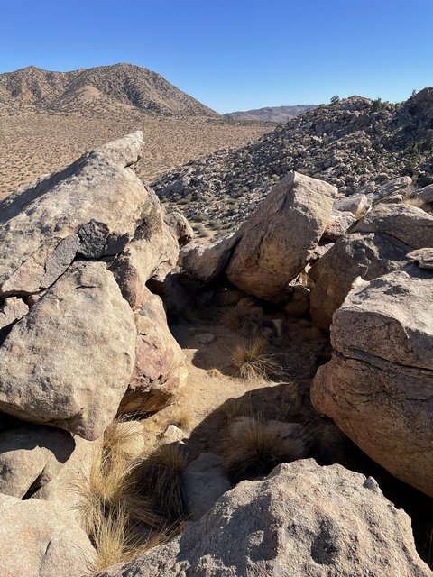
The Pocket
After this hike, it became clearer to me that if Bill were at all injured or in distress, he would not climb a hill like this. Maybe if in perfect health but just very lost would he do such a thing. Leaving a trail and expending the energy to climb a hill is a commitment that he would only undertake if he thought the reward was greater than the risk. I'll be in Palm Springs this week for work and I will try to sneak away early and get in a mid week hike to test a new theory I have regarding the cell phone ping. I'll report back with the results.
Here's the hike in light blue:

Mylar balloons collected: 2
GPS tracks are at https://caltopo.com/m/LL01
----
JD, hope you heal up well!
I chose to check out some hills near the CRHT in Lower Covington. I arrived at the Upper Covington trailhead Saturday around 10:30 AM and found an over-full parking lot, including about six Subaru Outbacks. I parked my car in the roundabout trying not to block the road, and ended up scratching my dang car against a rock. The travel to the peaks nearest the trail involved some treacherous rock hopping, which I was not thrilled to be doing (I always hike with a PLB). At the top of one of these boulder jumbles was a what I'll call a "pocket". A little bowl with a flat bottom, surrounded on all sides by rocks. If Bill sought shelter in one of these formations, who knows if he'll ever be found. But it was a beautiful day to be outside.
Venerable Mt. San J
Urocyon cinereoargenteus scottii
The Pocket
After this hike, it became clearer to me that if Bill were at all injured or in distress, he would not climb a hill like this. Maybe if in perfect health but just very lost would he do such a thing. Leaving a trail and expending the energy to climb a hill is a commitment that he would only undertake if he thought the reward was greater than the risk. I'll be in Palm Springs this week for work and I will try to sneak away early and get in a mid week hike to test a new theory I have regarding the cell phone ping. I'll report back with the results.
Here's the hike in light blue:
Mylar balloons collected: 2
GPS tracks are at https://caltopo.com/m/LL01
----
JD, hope you heal up well!
- bretpct
- Posts: 65
- Joined: Mon Feb 13, 2017 2:40 pm
Re: Story of missing hiker in Joshua Tree NP
![]() by jdclifford » Wed Nov 17, 2021 3:17 pm
by jdclifford » Wed Nov 17, 2021 3:17 pm
Awesome post again Bret, and thank you for the well wishes! I'm eating super healthy and taking every known vitamin and mineral conducive to bone regeneration to accelerate my healing. Still a long road ahead, but I'm aiming to get out there sometime between February and early May for a search, if even possible.
Love seeing your updates and the accompanying photos!
Love seeing your updates and the accompanying photos!
- jdclifford
- Posts: 58
- Joined: Sun Jan 19, 2020 11:48 pm
Re: Story of missing hiker in Joshua Tree NP
![]() by aeolian » Tue Nov 23, 2021 7:12 pm
by aeolian » Tue Nov 23, 2021 7:12 pm
Brett, I would consider pings from outside of 10.6 miles. And of course, Bill could have moved (quite a ways after the ping). The ping was Sunday morning at 6:50. The SAR operation was barely starting then. If I were Bill, I'd be in self-rescue mode and moving if able.
I've recently been working my way through the posts (up to page 42). Somewhere I crossed a discussion of CDMA2000 ping distances. With a single tower (like Bill's ping), distance is estimated based on signal strength. With line of sight and no interference, it should be accurate (within 5%). In addition to the typical RF problems that can affect signal strength, there's a phenomenon called atmospheric ducting, that can bounce a signal off a layer in the atmosphere. And if it occurs, it tends to occur in early morning's stable atmosphere. Ducting can produce a signal where normally there is no coverage. Unsure if ducting could produce a stronger signal, making Bill's ping further than it appears (weaker/closer seems possible). I'll edit and link the discussion if I find it again (found it). In any case, it's most reasonable to assume there was no ducting and the ping was 10.6 miles +/- 5% as reported.
I'll add that other lost hikers survived several days without water. Here's a related distraction Death Valley in '49, by William Lewis Manly
Last edited by aeolian on Wed Nov 24, 2021 1:09 pm, edited 1 time in total.
- aeolian
- Posts: 9
- Joined: Sun Oct 24, 2021 12:59 am
Re: Story of missing hiker in Joshua Tree NP
![]() by RichardK » Wed Nov 24, 2021 10:27 am
by RichardK » Wed Nov 24, 2021 10:27 am
aeolian - The distance from the tower to Bill's phone was NOT based on signal strength. It was based on the speed of light. The tower sends a signal to the phone traveling at the speed of light. The phone sends a response to the tower at the speed of light. The elapsed time gives you the distance. Somewhere in all of these posts, Otherhand did a field test with someone who had the equipment to monitor the tower. They found that these distance estimates were indeed accurate give or take.
If there was atmospheric ducting, the signal goes up and then comes down. It travels a longer path than a straight line. Likewise, if the signal bounced off a rock face. So, Bill would be a little closer than the calculated distance if either of these occurred.
Whether either one of these affected Bill's signal is raw speculation. The big questions remain. What was Bill doing miles past his intended goal of Quail Mountain? If he could could get that far, why didn't he just go back to his car?
- RichardK
- Posts: 181
- Joined: Tue Jan 22, 2013 10:52 pm
Return to Outdoors-Related Topics
Who is online
Users browsing this forum: No registered users and 99 guests