This trip was planned fairly recently, when I realized that these 28 miles were the only parts of both PCT Section B and Section C that I hadn't yet hiked. I had originally planned never to hike this piece of trail, as the first part entailed a blistering 6000-foot knee-busting descent into the desert, and the second part crossed the busy I-10 corridor in the middle of that very same hell-roasted desert. Life was far too short to submit myself to such nonsense. Then I finished the northernmost part of Section C in April, and I suddenly felt this nagging sense of incompleteness. I could bag two sections with one hike!
So I PM'd Florian here at the forum about road conditions, and he emailed me that the PCT was closed due to last year's Snow Fire, and Black Mountain Road was still closed for Winter. I was sad, but kind of glad, too, because it's a tough hike. And then a few weeks later I got yet another email from good old Florian. They had reopened the PCT, and the road was also open, but it still had snow and ice on the last north-facing mile. And so I waited, checking the weather for a good window. I absolutely wasn't going to cross the desert with temperatures in the nineties. A couple of weeks later, my window appeared. There would be one day in the mid-seventies, bracketed by two days in the eighties. I decided to hike downhill on the first day, then cross the desert on the low-temp day. Luckily, my wife agreed to pick me up on the far end. After I promised her unlimited foot rubs for the rest of the month. So we're both thanking Florian now.

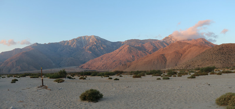
I drove up Black Mountain Road to the Fuller Ridge Trailhead, at sunset, with San Gorgonio across the way to the north
I stealth-camped in the back of my car in the trailhead parking lot. There were other people camping at the yellow post sites, and both groups had campfires lit. Very naughty. But I wasn't that worried, as campfires almost never get out of control, and I certainly wasn't going to make a stand and mention that this was currently forbidden by the USFS. Personally, I thought the smoke smelled kind of nice. And then I went to sleep early.
Day 1: Fuller Ridge to Snow Creek
The next morning I woke up at first light and started getting ready. And then I started hiking downhill in earnest. It was a long fifteen miles and 6000-plus feet to the desert floor and the next water source.
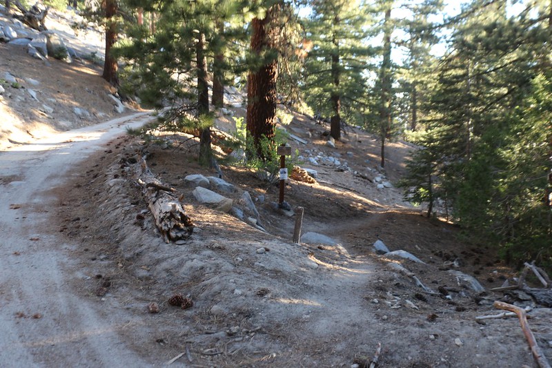
Where the PCT crosses Black Mountain Road just north of the Fuller Ridge Trailhead

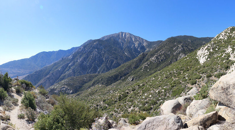
San Gorgonio Mountain and the nine peaks across the way to the north

I met up with two PCT Trail Angels waiting to give out some Trail Magic to the Thru-Hikers - Thanks, guys!
They had driven down the crazier section of dirt road beyond the Fuller Ridge side road. I'd never dared to go down there, as it isn't plowed, to my knowledge.

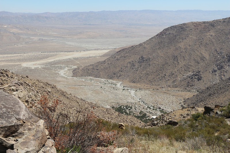
Panorama view east over the Coachella Valley with Snow Creek down below
San Jacinto Peak was showing behind Folly Peak. The cleft is the East Fork of Snow Creek
I entered the burned region from the Snow Fire of September 2020
The PCT was recently reopened in this area, and, technically, only the ground under the trail itself was opened. No camping was allowed. My original plan had been to hike the thirty-odd miles in three ten mile days, with one of them camping up on the ridge, and the other stop across the valley beyond the San Gorgonio Pass. But now I had to do it in two fifteen mile days. My feet were not amused.
Looking down into the Snow Creek valley and the Desert Water Agency's water tanks

Zoomed-in view of upper Snow Creek and San Jacinto Peak
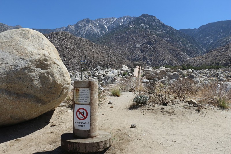
The famous water fountain on the PCT in Snow Creek, with San Jacinto Peak in the distance - a faucet would've been better
The Desert Water Agency's security car was hovering just up the road from the faucet, so I felt uncomfortable about camping nearby. It was intimidating. So after collecting a gallon of water I put on my pack and continued down the road, the pain in my feet notwithstanding. I remember what those guys did to Bluerail years ago, and I don't trust them very much.
I was getting closer to Snow Creek Village as I descended on the road

Looking south at San Jacinto Peak and the sign for Snow Creek Village as I continued looking for a campsite

It was quite windy, but I found a spot for my tent in a sandy wash that was only slightly protected from the gusts
Let's be honest: It was windy all night long. My tent shook and jumped and flapped continuously. It would have blown away entirely if I hadn't weighed all six stakes down with large boulders. I think I got a few hours sleep after midnight, but it surely wasn't enough.
Day 2 Snow Creek to the Whitewater Preserve
Just the same, I had set my alarm for 4am, and I figured that I might as well wake up since I wasn't getting much sleep anyway. I ate some pop tarts for breakfast and put away my gear. I moved one boulder and the tent took off for parts unknown! Or it would have if I hadn't grabbed it reflexively with one hand. The whole tent was flapping and waving up in the air as if I'd grabbed a giant eagle by its foot. It took everything I had to wrestle it back to earth again. I replaced the upwind boulders, none-too-gently, and proceeded to unclip the tent and tarp from the poles. I knew that there was no hope of rolling it up properly, so I simply grabbed each section and wadded it up the best I could, then crammed it into the stuff sack. It was still dark and I had to feel around in the sand for the stakes that had been flung into the air. I'm pretty sure that one of them is gone for good. Better that than chasing a flying tent across the desert at thirty-plus miles an hour!

Heading north on the Pacific Crest Trail toward I-10 and San Gorgonio Pass
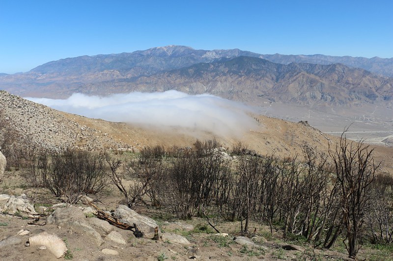
The marine layer was blowing in solid from the L.A. basin, and there was plenty of cool air along with it. The clouds evaporated further east when they hit the dry desert, but the pass was full of chilly, moist air. Just the way I'd planned it. Except for the windy part, that is.
Dawn light on San Jacinto Peak from the San Gorgonio River. It was a very dry river.

There was a non-windy place to stay under the overpass on I-10 - I should have stayed here! Too late now

Panorama view west in the morning light as I headed north from I-10

Empty lots and roads from a classic California real estate scheme and the PCT heads right on through

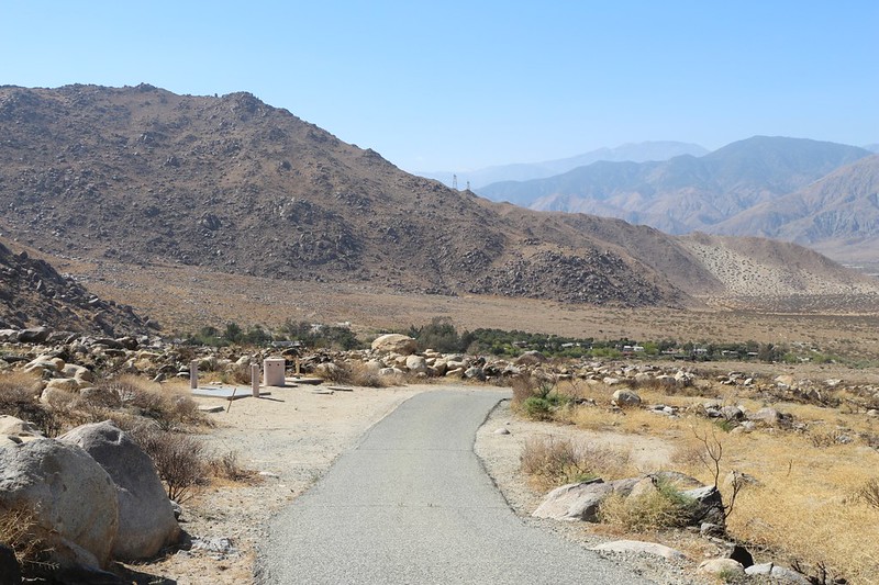
The Cottonwood Trailhead for the PCT in San Gorgonio Pass.
This was where I had planned to camp on the second night, under my original plan. I was going to stash a gallon of water here beforehand.

Unusual sign stating "Warning - Wind Farm, Electrical and Flying Debris Hazard" as I entered an area with windmills.
This canyon headed east and north, and led toward the Mesa Wind Farm. Most of the windmills up above on the ridges were the smaller, older versions, and were obviously being decommissioned one by one.
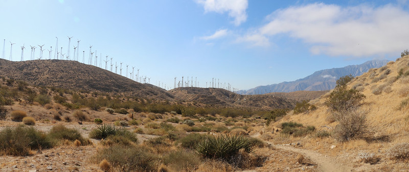
Panorama view of windmills and the Mesa Wind Farm
I climbed on up and out of the long canyon, went over a saddle, and headed northeast, down into yet another canyon. But this one eventually drained into the Whitewater River.

Hiking on the PCT toward the Whitewater Preserve - eight miles finished and five more to go!

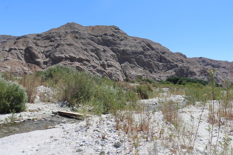
Looking east as I neared the Whitewater Preserve - the Whitewater riverbed is down in that big canyon

Panorama view over the Whitewater River valley as I headed down the switchbacks
I took the half mile side trail toward the preserve. I was done with the PCT for now.
Small wooden bridge that crosses the Whitewater River near the Whitewater Preserve

Cooling my hot feet in the clear waters of the Whitewater River - Aaaaaahhhhhhh!!!!
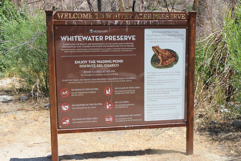
Welcome sign at the Whitewater Preserve
There was no cell phone signal at the preserve, so I texted my wife to come and get me via satellite, using my InReach. And then I hung out in the shade of the big trees and generally enjoyed myself. That place is truly an oasis in the desert!
It took a couple of hours thanks to drizzle on the L.A. side causing traffic issues, but eventually I was picked up and we drove back up to Fuller Ridge and my car. We had thought about staying in the car that night and day-hiking toward San Jacinto Peak from there the next day, but my feet were totally shot. I had three blisters, which was very unusual for me, and I decided that the best thing to do was to head on home and keep off my feet for a day or three. And that's what we did.
Just the same, I was quite pleased with myself. I had finally finished hiking PCT Sections B and C! It was a done deal. Now all I had left was the last part of Section D, not counting the other 1800 miles I hadn't hiked. Ha ha! At least there's something for me to look forward to!
For my GPS track and topo map see my CalTopo Page
For more photos and videos see my Flickr Page
Happy hiking!