
Mt. San Jacinto Outdoor Recreation
Hiking, Climbing, Camping, Trail Running, Snowshoeing...
Cranston Fire in San Jacintos
Re: Cranston Fire in San Jacintos
![]() by Florian » Sun Jul 29, 2018 11:30 am
by Florian » Sun Jul 29, 2018 11:30 am
Evacuation order for Idyllwild residents has been lifted. Proof of residency required. Only access is via hwy 243 from Banning side. No access via hwy 74.
-

Florian - Posts: 1437
- Joined: Sat May 16, 2009 4:49 pm
- Location: Palm Springs
Re: Cranston Fire in San Jacintos
![]() by Wildhorse » Sun Jul 29, 2018 11:36 am
by Wildhorse » Sun Jul 29, 2018 11:36 am
To Cynthia's question: My guess is that Idyllwild and the forest will be gone well before the century's end. The desert will become even more dangerous in the hot months than it is now. Maybe five hundred or a thousand years in the future, when the human population is much lower than today, and temperatures may have begun cooling again, hiking could be great for the surviving humans, if any. My guess is that technology will not prevail against it, and that sustainability is fantasy.
I hope that furry animals and birds survive, and that trees come back. I love them the most. Love is partial that way.
I hope that furry animals and birds survive, and that trees come back. I love them the most. Love is partial that way.
- Wildhorse
- Posts: 548
- Joined: Tue Oct 19, 2010 1:11 pm
Re: Cranston Fire in San Jacintos
![]() by cynthia23 » Sun Jul 29, 2018 2:14 pm
by cynthia23 » Sun Jul 29, 2018 2:14 pm
Just read in sanjacjon's blog that the tram is opening tomorrow, with limited access (Long Valley trail only). Major props to the firefighters--what they did here is basically a miracle.
Wildhorse--you paint a grim picture and nowadays, it's sure hard to be optimistic. If we're going to survive we desperately need to develop carbon capture technologies, along, of course, with ceasing the use of fossil fuels pretty much immediately. Because when it's 90 in the Arctic circle, it's well past time to do something.
Wildhorse--you paint a grim picture and nowadays, it's sure hard to be optimistic. If we're going to survive we desperately need to develop carbon capture technologies, along, of course, with ceasing the use of fossil fuels pretty much immediately. Because when it's 90 in the Arctic circle, it's well past time to do something.
Q: How many therapists does it take to screw in a light bulb? A: Only one, but the light bulb has to want to change ...
- cynthia23
- Posts: 1289
- Joined: Tue Nov 07, 2006 3:33 pm
- Location: Rancho Mirage
Re: Cranston Fire in San Jacintos
![]() by Pitownpi » Sun Jul 29, 2018 3:14 pm
by Pitownpi » Sun Jul 29, 2018 3:14 pm
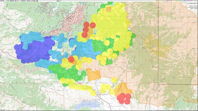
colored circles are the Cranston Fire hotspots
the shaded orange bit is the Mountain Fire Burn.
Cranston pretty much filled in where the Mountain fire left off......
from Socalmountains.com
the shaded orange bit is the Mountain Fire Burn.
Cranston pretty much filled in where the Mountain fire left off......
from Socalmountains.com
- Pitownpi
- Posts: 152
- Joined: Sat May 15, 2010 8:41 am
Re: Cranston Fire in San Jacintos
![]() by Wildhorse » Sun Jul 29, 2018 4:26 pm
by Wildhorse » Sun Jul 29, 2018 4:26 pm
Pitownpi, thanks for this map. It helps to understand what happened.
It appears that the Mountain Fire, and relatively mild winds in a favorable direction, effectively reduced the potential of Cranston fire. SW Idyllwild was largely protected initially by the fuel break and fortunate wind speed and direction, even while five houses burned. The Mountain fire, with the help of water drops, again along with fortunate wind speed and direction, further protected Idyllwild and Tahquitz Valley. The Mountain Fire effectively created a huge fuel break. The Cranston fire has expanded that fuel break. The whole mountain range will become a fuel break if this trend continues.
(I don't like the term "fuel" for trees and other plant life. But that is a term frequently used by people who advocate forest thinning or clear-cutting for the sake of protecting people and their houses and other economic assets.)
This was a bad fire. It hurt wildlife and people. Some people lost houses. Many others suffered trauma that will have lingering effects, even permanent effects. All of us have lost the forest as it was. It was caused by an arsonist who may have timed the fire to coincide with a heat wave. I am glad the fire is largely over. But the effects on people and wildlife continue. In spite of it, I expect people to keep building in the forest and continue to use it for entertainment and economic gain.
- Wildhorse
- Posts: 548
- Joined: Tue Oct 19, 2010 1:11 pm
Re: Cranston Fire in San Jacintos
![]() by Wolfdog77 » Mon Jul 30, 2018 11:01 pm
by Wolfdog77 » Mon Jul 30, 2018 11:01 pm
Yes, as hard as it is, have to optimistic. The first fire I experienced up there, was the Soboba Fire of 74. It completely scorched an entire stretch along 243 from the Vista Point to Poppet Flats cut off with only Fulmor Lake spared. Remember seeing many, many tall ghostly blackened pines and thinking I would never see a mature forest like that again in that area in my lifetime. Well, fast forward 44 years, and now I see almost no signs of what that fire did, with only the exception of fallen burnt trunk stem found here and there. Love hiking up the Black Mountain Trail, fully rejuvenated, just wouldn't catch me hiking up it back in the 70s/80s.
-
Wolfdog77 - Posts: 8
- Joined: Mon Jul 30, 2018 10:33 pm
Re: Cranston Fire in San Jacintos
![]() by Florian » Tue Jul 31, 2018 6:37 am
by Florian » Tue Jul 31, 2018 6:37 am
Hwy 243 to Idyllwild from Banning now open to anyone regardless of residency. No access to Idyllwild via hwy 74 from Hemet or Garner Valley. PS tramway is open but hiking only allowed in Long Valley. All other trails and campgrounds on the mtn remain closed.
-
Florian - Posts: 1437
- Joined: Sat May 16, 2009 4:49 pm
- Location: Palm Springs
Re: Cranston Fire in San Jacintos
![]() by Wildhorse » Tue Jul 31, 2018 2:46 pm
by Wildhorse » Tue Jul 31, 2018 2:46 pm
Wolfdog77, that is interesting history. I have heard about another fire, late 1990s or around 2000, that was particularly significant to Idyllwild. My memory is fuzzy, but I think it required evacuation and that the big fire abatement efforts began in its aftermath and eventually led to cutting the large fuel break including the one thru the nature center cut around 2003 or 4 if my memory is right. Bark beetles and drought were another factor around those times. I am wondering what recollections you may have about those times?
- Wildhorse
- Posts: 548
- Joined: Tue Oct 19, 2010 1:11 pm
Re: Cranston Fire in San Jacintos
![]() by Wolfdog77 » Tue Aug 20, 2019 10:26 pm
by Wolfdog77 » Tue Aug 20, 2019 10:26 pm
Apologies for my one-year delayed response. Yes we lost nearly 95% of all our ponderosas on a 1.3 acre plot of land that we owned above Fern Valley. All succumbed to bark beetle infestation during 2002. Even lost scores of incense cedar, black oak as well. If I remember right, the water year total from July 1st 2001, to June 31st of 2002 was under 8 inches in precipitation, a very, very dry water year. We even lost a ponderosa pine that was 365 years old, the last to go the but toughest fighter of ponderosa on our block. It survived a forest fire due to evidence of visible interior burn scar marks that seem to indicate that a fire came through the area possibly in the early 1800s or earlier. Regardless, it was a full blown black plague that mainly affected the Ponderosas all over Idyllwild back in 2002.
~Wolfdog~
~Wolfdog~
-
Wolfdog77 - Posts: 8
- Joined: Mon Jul 30, 2018 10:33 pm
Re: Cranston Fire in San Jacintos
![]() by Wildhorse » Wed Aug 21, 2019 1:10 pm
by Wildhorse » Wed Aug 21, 2019 1:10 pm
Thank you, Wolfdog. That was such a traumatic time. So many trees died.
- Wildhorse
- Posts: 548
- Joined: Tue Oct 19, 2010 1:11 pm
Return to Mt. San Jacinto & Santa Rosa Mountains
Who is online
Users browsing this forum: Bing [Bot] and 104 guests