...but you didn't come here for a weather report about America's Finest City, now did you!!! However nice today may have been down here, it surely cannot compare to the perfection that was Saturday at San Jacinto. The conditions were in stark contrast to my trip up Baldy (via Old Baldy Trail) two weeks ago.
Our day began around 4:45 as we (my fiancee and I) departed from San Diego, arriving at Deer Springs Trailhead around 7. Prior to leaving I had heard of the cooler temperatures this weekend. I smartly packed some smartwool layers that came in handy almost immediately -- the moment we exited the car, we felt the frigid cold. To my surprise, the car's outside temperature gauge read 35 degrees! I never thought it would have been that cold. We hit the trail around 7:30, ascending the modest slopes Deer Springs Trail had to offer, and both of us warmed up rather quickly.
As someone who yearns for the steepest trails possible, gently meandering up Deer Springs was incredibly refreshing and pleasant. Flowers the color of purple, blue, orange, yellow, and red were all in full bloom. The last time I'd gone up this trail was 12 years ago, but stopped shortly after the Suicide Rock Trail turnoff due to heavy snow. This time around, there was no snow and we made our way past the Suicide Rock turnoff and headed for Strawberry Junction.
Knowing we were going to make a loop out of this hike, my goal was to ascend the steeper approach to the summit while descending the less steep route back down. That in mind, once we arrived at Strawberry Junction, we headed due north (left) on Deer Springs Trail, passing up the junctions with Marion Mountain/Seven Pines Trails and later on, Fuller Ridge Trail. Along the way up there were patches of wind but overall it was blue skies, calm wind, and the feeling of floating on clouds as we looked out into the distance and saw the dense cloud cover at lower elevations.
Not long after passing Deer Springs Creek crossing, we came upon a very interesting man, Asian (possibly Japanese) and in his 50's. He was jovial and even though we were headed towards the peak, he made sure to let us know the peak was the way we were going. After stopping and chatting with him, come to find out he was a PCT thru-hiker. All the way from Mexico. And on the way to CANADA! My mind was blown at that point. After all my years hiking various segments of the PCT and I finally came face-to-face with a person on-trail that was actually in the midst of a full Mexico-to-Canada PCT hike. The only thing I regret doing was not asking to take a picture with him. We then continued up the trail setting our sights for Little Round Valley, when the faint sound of running water became louder and louder. As we finally arrived at its junction with the trail, we took in the beautiful sights and sounds. I'd never expected to run into such a large stream and waterfall on a SanJ trail. Am guessing this was Upper Bed Springs Crossing but will need your help confirming.
After cresting at Little Round Valley, we made the leisurely stroll until the final set of switchbacks took us up to the saddle between San Jacinto and Jean. After seeing the throng of "trammer's" at this point, we immediately yearned for solitude. Somewhere. Anywhere…and it would come in due time. Meanwhile, we headed up boulder-strewn ridge and took in some amazing views from San Jacinto summit. Every time I come up here I always wonder what it would be like on the summit during a blizzard or some other extreme winter condition. Probably hell! Survivable? And I mean survivable on the very tippy top? It's fun to imagine it, but probably far from that to actually endure it.
Having headed up the west side, it was time to descend the east side. The increase in traffic was expected and tolerable, to a degree. It's always fascinating looking out in the distance and seeing the upper tram station juxtaposed with the grid of streets that is Palm Springs. Making great time heading downhill, we broke away from the crowds (sort of) at Wellman Divide and began our descent down the Wellman Cienega Trail. I always loved this section of trail due to the three or four areas of "weeping walls" within the Wellman Cienega. I don't know why, but the place reminds me of The Shire from Lord of the Rings.
For the first time in years, I broke new ground in SanJ. Up until this weekend, I'd only ever taken the Wellman Cienega Trail en-route from Humber Park (via Devils Slide). But Saturday as we were descending that very trail, we went west on PCT towards Strawberry Junction, instead of south on PCT toward Saddle Junction. Clearly San Jacinto was saving the best for last. That solitude we were searching for up near the summit was about to come into reality. We didn't know it at the time, but the last people we saw on the mountain were at the junction of PCT and Wellman Cienega Trail. The final 6.5 miles were hiked in complete isolation from all of other visitors of San Jacinto State Park.
After leaving the PCT/Wellman Cienega junction behind, we made our way on PCT, immediately making a small ascent up and over a little saddle between what I believe to be Cienega Peak(?) and one of the ridges of Marion Mountain. Almost immediately after descending down the other side of this saddle, a vast and beautiful vista opened up before my very eyes. Gazing out in the distance was Idyllwild nestled tightly in between Tahquitz Peak and Lily Rock to the left, and Suicide Rock to the right. Seeing all of this exposed granite within a deep valley, while traversing a mountainside amongst giant pine trees, I could not help but feel as if I'd teleported to Yosemite, specifically the Pohono Trail (my current all-time favorite trail in terms of sheer enjoyment and scenery). For those that have been on Pohono going in the direction from Taft Point to Glacier Point, you will completely understand.
Once we passed Strawberry Junction and made the final descent down Deer Spring Trail, we were both sort of on auto-pilot mode at that point, bolting down the mountain at a brisk pace. We took time to snap more pictures of the beautiful flowers, then at long last, arrived back at the trailhead.
From a day-hikers perspective, I refer to this hike as the "Tour of San Jacinto" because it offers up a fairly comprehensive tour of both the west and east sides of the mountain -- that in under 20 miles. Obviously being a loop hike, there might be a way to plan out a point-to-point hike that would be even more comprehensive.
QUESTIONS
1.) The stream and waterfall I had referred to earlier on Deer Springs Trail just before Little Round Valley...was that indeed Upper Bed Springs? Not sure if this picture helps:

2.) As I was descending PCT toward Strawberry Junction, I came across a sign that said "entering San Jacinto Wilderness". Then as I passed it and looked back the sign going the other way said "entering San Jacinto State Park Wilderness". So, are there two separate wilderness locations within the Santa Jacinto Mountains, just with different designations?
3.) Is there a name for the outcropping of exposed rock that appears on the topo below as a high point? This was on PCT headed towards Strawberry Junction:

ROUTE MAPS & PHOTOS
Overall route and direction of travel
 01 by mattytreks
This was the absolutely gorgeous section of PCT I was referring to earlier
 02 by mattytreks
Above the clouds, looking out into the distance from Deer Springs Trail beyond the junction of Fuller Ridge Trail
 01 by mattytreks
Close-up of icicles on...Upper Bed Springs Crossing?
 02 by mattytreks
Obligatory summit photo with SanJ sign
 03 by mattytreks
Looking west/southwest, viewing the cloud cover from the summit
 04 by mattytreks
Me and SanG
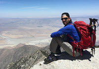
 05 by mattytreks
Dork in the foreground; Banning Pass down below in the background
 06 by mattytreks
For the gear junkies out there who are curious, the pack is a Gregory Z30 (Model 2015), Brooks Cascadia shoes, and Dirty Girl gaiters
 07 by mattytreks
Pano of SanG (top left), Snow Creek (bottom-leftish), Leatherneck Ridge? (center), Upper Tram Station and Palm Springs (far right)
 08 by mattytreks
Quick photo op on the giant switchback on the Peak Trail
 09 by mattytreks
My favorite view from the most scenic portion of PCT during this hike. Taken between the junction of Wellman Cienega Trail and Strawberry Junction
 10 by mattytreks
View up Marion Mountain from PCT
 11 by mattytreks
Interesting-looking bush/tree. Appears that part of it's trunk is living while other parts are dead
 12 by mattytreks
Vibrant, beautiful flowers dotted Deer Springs Trail
 13 by mattytreks
Close-up of purple flower
 14 by mattytreks
Sunlit ferns near Deer Springs Trailhead
 15 by mattytreks
That's all for now. Until then, keep enjoying the mountains!!