Adam - We know that Bill turned his phone off after his morning calls because he didn't ping any more cell towers on the way to JT. So, when did he first turn it on, why did he turn it on, did he turn it on and off repeatedly or turn it on and leave it on? Was he of sound mind trying to be rescued or was he in a stupor acting randomly or was he leaving a false trail?
You ask: "how is Bill out for 2 1/2 days without hitting a trail and/or a cell tower?" That question assumes that he was looking for a trail and/or trying to hit a cell tower. Was he doing either one? These activities imply that either Bill was lost or that he was injured but ambulatory which in turn imply that he expanded on his itinerary of Quail Mountain.
Did he willingly go somewhere other than Quail? He very likely had already hiked Lost Horse and stated that very morning that he wanted to be out of the park by 5PM. I don't see him adding more hiking to his already ambitious plans. Neither of us accepts that he went to SWC looking for water when he could have easily just gone back to his car.
What does that leave? Either Bill lost it mentally or he staged his own disappearance. If there is another realistic possibility, I can't think of it.

Mt. San Jacinto Outdoor Recreation
Hiking, Climbing, Camping, Trail Running, Snowshoeing...
Story of missing hiker in Joshua Tree NP
Re: Story of missing hiker in Joshua Tree NP
![]() by RichardK » Mon Jul 06, 2015 6:54 pm
by RichardK » Mon Jul 06, 2015 6:54 pm
- RichardK
- Posts: 181
- Joined: Tue Jan 22, 2013 10:52 pm
Re: Story of missing hiker in Joshua Tree NP
![]() by adamghost » Mon Jul 06, 2015 10:55 pm
by adamghost » Mon Jul 06, 2015 10:55 pm
Your logic seems sound to me. I think "lost it mentally" is totally plausible and in fact the closest parallel to the Bill case is another hiker who I believe was lost and rescued later that year in JTNP and who reported that he wandered for days in a trance-like state and could offer no explanation for his behavior.
I just can't figure out where the dickens he would have gone while still making that ping....unless he ignored very well defined roads and trails - which is possible I suppose. When I was circling around the bottom of UC I recall seeing a wide wash leading south from there. It was very inviting looking. No reasonable scenario would put Bill down that wash - it's well shy of 10.6 so he would have had to backtrack to that point, crossing a very obvious trail (twice, actually - Bill also has to cross the Covington Crest Trail to get to the UC ping spot too but the angle of travel is such that it's just possible he could have missed it. Further south, though, it's much more obvious) and also missing a nearby road. But when I think of Bill wandering those are the kinds of places I tend to think of.
If Bill's so out of it that he crosses a road, then the sky's the limit in terms of where he might have gone. But one would guess that even in a trance he'd wander on a road, right? I like you thought going up the California R&HT in a daze was a pretty probable scenario. But it's hard to understand why he doesn't just come out the other end then. The topography from what I've gathered from google maps (I haven't hiked it further south than SWC) would tend to take you to Lower Covington. Same if he came up the canyon from west of Stubbe Springs (a theory I was liking for awhile). The detour to UC is possible but it's hard to understand. And all but one entry to UC the road leading to the trailhead is blindingly obvious.
I have to say, every scenario I run for Bill's disappearance keeps taking me back to Upper Covington. Not saying he couldn't be anywhere else, and I've already said why it's hard to get him there, but that's just where the math takes me. But man, that little ping area, I've been all over it and Tom's been there a few times too, not to mention the areas around it. It's not difficult terrain. I suppose he still might have been missed but I almost feel like I've memorized it. And if he isn't there, I just can't think of any likely place he goes from there. I did 2-3 trips looking for somewhere, and came up with nothing. The badlands suck and there's a road or trail in every other direction.
- adamghost
- Posts: 57
- Joined: Tue Jun 23, 2015 12:47 pm
Re: Story of missing hiker in Joshua Tree NP
![]() by adamghost » Mon Jul 06, 2015 11:10 pm
by adamghost » Mon Jul 06, 2015 11:10 pm
So following on my previous post - to me it's hard to have Bill wandering if he doesn't make it to Upper Covington, but it's also hard to get Bill to Upper Covington, as I've already said. So...is there another area where Bill could ping at 10.6 miles and then wander off and not be found? The only other place that fills that bill to me is northern side of SWC, but that would be really bizarre, as in "there's a road right here, and there's a nice easy flat area and a visible town on the far side of it over here, but why don't I just climb this ridiculously steep thing in front of me instead?" bizarre. (The topography isn't that compact, but that's the basic gist of it anyway)
Thoughts? I know Ric has an idea he somehow got to the other side of Park Road. Remember that only a few hours after the ping, the search is underway in earnest and searchers and helicopters are starting to nudge into the area.
Thoughts? I know Ric has an idea he somehow got to the other side of Park Road. Remember that only a few hours after the ping, the search is underway in earnest and searchers and helicopters are starting to nudge into the area.
- adamghost
- Posts: 57
- Joined: Tue Jun 23, 2015 12:47 pm
Re: Story of missing hiker in Joshua Tree NP
![]() by Ric Capucho » Mon Jul 06, 2015 11:40 pm
by Ric Capucho » Mon Jul 06, 2015 11:40 pm
Ric has the idea that he somehow got himself to the Park Road on the very first night or early that morning, possibly only a few steps away on either side, rested up inside a rock pile waiting for a passing car and somehow succumbed before he could get himself picked up. Snake bite? Heart problem? A deep sleep that he never woke up from? Just a step too much getting himself out of the wilderness?
Days later, my usual tropo propagatation theory carries the ping to the tower as a complete fluke. Old style non-smart phones could remained powered up for days, and warmth extends the battery a little longer. I've been cool on the idea that the ping confirms mobility for years, and am now almost as cool that the ping needed a mobile thumb to power up the phone that Sunday morning.
Problem is that the large piles of rocks either side of Park I can see when I "walk" the road on Google Earth look close enough to the road that a passerby stopping for a quick pee or evocative photo would surely have stumbled on his remains, even if they're nested in some dark nook or cranny.
Alternatively, Bill's to be found in the badlands west of Upper Covington. He sees the lights of DHS, and triggered by the delusion that he can walk home to the borrowed apartment descends into Adam's broad canyon. Doesn't get far, and same ping scenario as usual (trop prop).
So either the far east or the far west of the arc, because everything in between has pretty much covered. I agree that Bill ascending the highland north of SWC is unlikely regardless of Bill's mental state. Although as I've stated countless times military people are trained to run uphill in an emergency.
Ric
- Ric Capucho
- Posts: 111
- Joined: Wed Aug 21, 2013 12:54 pm
Re: Story of missing hiker in Joshua Tree NP
![]() by RichardK » Tue Jul 07, 2015 6:01 am
by RichardK » Tue Jul 07, 2015 6:01 am
Ric - Even if Bill's phone bounced a signal off a tropo duct, the 10.6 mile arc is still a hard outer limit set by the speed of light. He might have been closer, but could not have been further out. So, Bill is down in some gully without line of sight to the tower. The atmosphere bounces a brief ping to the tower. The gully might be only 8 or 9 miles to the tower, but cannot be more than 10.6 miles away.
It might be useful to read the Wikipedia entry for tropospheric ducting. It seems to usually function over distances of hundreds of miles. The topography of JT may not be suited for it according to this statement:
High mountainous areas and undulating terrain between the transmitter and receiver can form an effective barrier to tropospheric signals. Ideally, a relatively flat land path between the transmitter and receiver is ideal for tropospheric ducting. Sea paths also tend to produce superior results.
- RichardK
- Posts: 181
- Joined: Tue Jan 22, 2013 10:52 pm
Re: Story of missing hiker in Joshua Tree NP
![]() by adamghost » Tue Jul 07, 2015 12:21 pm
by adamghost » Tue Jul 07, 2015 12:21 pm
OK, let's ponder the ducting idea. I was thinking this over this morning.
First question is does the battery stay on for three days? It would be worth checking out...does anyone have an old flip phone they could run down? Keep in mind that the phone would be searching for a tower the whole time which would tend to run the battery down. Another point to consider: apparently Bill switched his phone off to get into the park. So at some point for this to work he would also have had to switch the phone on. Which means he would have had to have been somewhere where he thought he could get a call out, and have a reason to call. Which I think rules out a sudden death scenario. I doubt that he'd fall on the phone and it would then turn on. So I think we can still safely assume that at some point Thursday night, unless he falls unconscious for an extended length of time, Bill turns the phone on to try to call for help/give reassurance, depending on what the situation is.
OK, next point, let's consider the location. Here's the map from my website (again borrowed from Tom's) with the places that I'm aware of that you can get reception along the line:
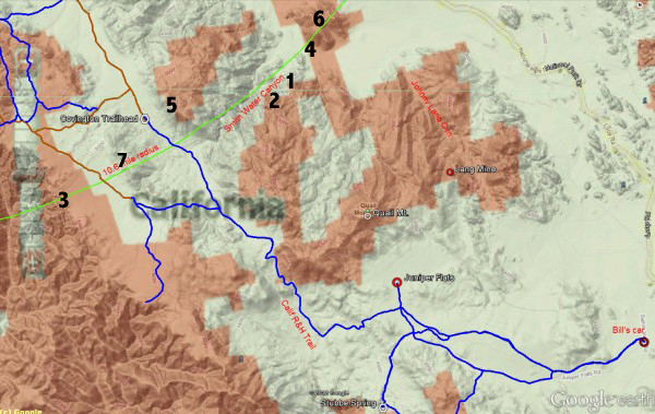
(Referencing to prior posts, the "magic bullet" spot is at 1, and the "UC ping spot" is at 3)
So right away you see the problem; the 10.6 line runs right through Smith Water, and inside the 10.6 line you're on the north side. Further down the line towards the west you have the low-ish (it's not THAT low) hill that both Myth and I checked out, and then you're into UC. I have probably walked about 60-70% of that line myself. I'm not saying I couldn't have missed Bill, but I'm hard pressed to think of WHERE this ducting event might have occurred. You're awful close to roads and trails anywhere in there, in Smith Water you're looking at the north face, and we've already discussed UC. How about to the northeast, up by Park Road? The problem I have with that scenario is that IIRC that area was the route in for many of the search parties (not to mention many of the ones since). I guess if I was told that this scenario was the right one, I'd probably look proximate to where the number "4" is....but....that's probably the most reliable cell reception in the whole area. I've called people from there and had sustained conversations. So I don't know why Bill doesn't just phone home if that's where he's at.
Up by Park Road, I'll tell you what, you can't get a call out anywhere near there, as I know to my chagrin because I got a flat on one of my trips when I was parked there and we had to drive several miles on the rim to contact AAA. Under the ducting theory I suppose that wouldn't matter, but I'm just sayin'.
Thoughts?
First question is does the battery stay on for three days? It would be worth checking out...does anyone have an old flip phone they could run down? Keep in mind that the phone would be searching for a tower the whole time which would tend to run the battery down. Another point to consider: apparently Bill switched his phone off to get into the park. So at some point for this to work he would also have had to switch the phone on. Which means he would have had to have been somewhere where he thought he could get a call out, and have a reason to call. Which I think rules out a sudden death scenario. I doubt that he'd fall on the phone and it would then turn on. So I think we can still safely assume that at some point Thursday night, unless he falls unconscious for an extended length of time, Bill turns the phone on to try to call for help/give reassurance, depending on what the situation is.
OK, next point, let's consider the location. Here's the map from my website (again borrowed from Tom's) with the places that I'm aware of that you can get reception along the line:
(Referencing to prior posts, the "magic bullet" spot is at 1, and the "UC ping spot" is at 3)
So right away you see the problem; the 10.6 line runs right through Smith Water, and inside the 10.6 line you're on the north side. Further down the line towards the west you have the low-ish (it's not THAT low) hill that both Myth and I checked out, and then you're into UC. I have probably walked about 60-70% of that line myself. I'm not saying I couldn't have missed Bill, but I'm hard pressed to think of WHERE this ducting event might have occurred. You're awful close to roads and trails anywhere in there, in Smith Water you're looking at the north face, and we've already discussed UC. How about to the northeast, up by Park Road? The problem I have with that scenario is that IIRC that area was the route in for many of the search parties (not to mention many of the ones since). I guess if I was told that this scenario was the right one, I'd probably look proximate to where the number "4" is....but....that's probably the most reliable cell reception in the whole area. I've called people from there and had sustained conversations. So I don't know why Bill doesn't just phone home if that's where he's at.
Up by Park Road, I'll tell you what, you can't get a call out anywhere near there, as I know to my chagrin because I got a flat on one of my trips when I was parked there and we had to drive several miles on the rim to contact AAA. Under the ducting theory I suppose that wouldn't matter, but I'm just sayin'.
Thoughts?
Last edited by adamghost on Tue Jul 07, 2015 12:26 pm, edited 1 time in total.
- adamghost
- Posts: 57
- Joined: Tue Jun 23, 2015 12:47 pm
Re: Story of missing hiker in Joshua Tree NP
![]() by Ric Capucho » Tue Jul 07, 2015 12:25 pm
by Ric Capucho » Tue Jul 07, 2015 12:25 pm
Hi Richard,
Tropo ducting is more famous for propagating radio or tv for hundreds or even thousands of miles beyond their usual range, and there's a whole community of hobbyists that enjoy the extra channels from exotic places, hence the Wikipedia wording "produce superior results".
However, my main source on tropo ducting for cellphone towers is a paper that I found somewhere. Towers are setup specifically to stop shorter range ducting, using tricks such as deliberately "not looking up" (above 5-10 degrees of the vertical). Ducting fron the tower next door isn't a problem, but a few more towers left or right is a problem. On a bad night (must dig out that paper) cell towers can really trip each other up and bring down the network across several cells. And by "bad night" I mean the early morning hours around sunrise. Celltower engineers consider "superior results" to be a design and installation that avoids ducting like the plague.
The 10.6 mile estimate is the one fact we have to go on. Ducting (or rock reflections or whatever) mean that it could indeed be overstated by a couple of miles. However, the estimation has a 10% error plus or minus, so we really should keep to an outer limit of 11.6 miles. But as you say the direct inner limit can be as low as 9.6 miles, less the reflection or ducting might push it as low as 8-9 miles as you say. Which might not sound a lot closer than 10.6 miles, but could put him a step closer to Yucca Valley than SWC, and I believe that might have been a rationale for Tom looking (for example) in the vicinity of Molina Cove just north of the Covingtons.
Ric
- Ric Capucho
- Posts: 111
- Joined: Wed Aug 21, 2013 12:54 pm
Re: Story of missing hiker in Joshua Tree NP
![]() by adamghost » Tue Jul 07, 2015 12:30 pm
by adamghost » Tue Jul 07, 2015 12:30 pm
Ric Capucho wrote:Which might not sound a lot closer than 10.6 miles, but could put him a step closer to Yucca Valley than SWC, and I believe that might have been a rationale for Tom looking (for example) in the vicinity of Molina Cove just north of the Covingtons.
Ric
Well, you COULD walk all the way to Molina Cove from Bill's car without pinging a tower, most likely, on roads and trails. I did start walking the sides of the road into the Covingtons as Myth suggested, but mostly there really isn't enough shade to tempt Bill off the road, and the search trails imply that they did check along the roads into the area, so it didn't seem worth the effort to me.
I mean, once you're within 10.6 miles of Serin you're on a road pretty much (if you didn't climb the north side of SWC). That's one of the head-scratchers here.
- adamghost
- Posts: 57
- Joined: Tue Jun 23, 2015 12:47 pm
Re: Story of missing hiker in Joshua Tree NP
![]() by Ric Capucho » Tue Jul 07, 2015 12:52 pm
by Ric Capucho » Tue Jul 07, 2015 12:52 pm
Hey Adam,
Ok, meant to range the distances ages ago and never got round to it. But here we go...
The Final Search Map on Tom's website shows two sets of original searcher tracks starting from the south west of what I'll call Hill 2353 (the obvious hill roughly ENE of Samuelsons on the other side of the Park Road). The northernmost of those tracks starts at around 11.5 miles from Serin and the slightly more southerly (starting at the layby BM 3871, by the looks of it) is 11.7 miles. Both at the very outer edge of the pingable arc.
According to the colour coding of the tracks, the more northern tracks were made on Day 4, Tuesday the 29th - and shows the searchers heading past Samuelsons and on into SWC. The southern tracks were laid on Day 2, Sunday 27th, and shows the searchers heading on straight down and through Johnny Lang. The Final Map does show a helicopter scouting that area of Park Road on Day 5, the Wednesday.
Interestingly, every mile northwest on that stretch of the Park Road is a mile closer to Serin as it's heading in that direction.
So no there weren't searchers swarming around the pingable stretch of Park Road during the intensive search.
Look, don't take this as anything else than due diligence, but the pingable stretch of Park Road doesn't appear to have ever been cleared.
Ric
- Ric Capucho
- Posts: 111
- Joined: Wed Aug 21, 2013 12:54 pm
Re: Story of missing hiker in Joshua Tree NP
![]() by adamghost » Tue Jul 07, 2015 9:07 pm
by adamghost » Tue Jul 07, 2015 9:07 pm
OK, just so I understand you, when you say "pingable stretch" of Park Road you just mean the area of Park Road that's around 10.6 miles, right? Because I can verify you the cost of a new tire there's not even a hint or breath of cell phone reception around there...but if I follow you you're thinking a transitory ducting event, right?
FWIW, people do park along that stretch quite a lot. There's several turnouts around there and unlike all the other places we are ballparking, Park Road gets a lot of traffic. It's pretty common for folks to pull over and walk a little bit, take photos, etc. So it's not totally unvisited territory. I mean, Bill could be there but he'd be way harder to miss than almost anywhere else you can think of. So all things taken together I'd feel like the probabilities would be pretty low. But I think I take your point.
FWIW, people do park along that stretch quite a lot. There's several turnouts around there and unlike all the other places we are ballparking, Park Road gets a lot of traffic. It's pretty common for folks to pull over and walk a little bit, take photos, etc. So it's not totally unvisited territory. I mean, Bill could be there but he'd be way harder to miss than almost anywhere else you can think of. So all things taken together I'd feel like the probabilities would be pretty low. But I think I take your point.
- adamghost
- Posts: 57
- Joined: Tue Jun 23, 2015 12:47 pm
Return to Outdoors-Related Topics
Who is online
Users browsing this forum: No registered users and 3 guests