Hey folks,
I've been lurking on this board for a couple years. I think the amount of effort going into this search is commendable.
I have a water related question: does anyone know if Mr. Ewasko had a history of water caching?
Gerry

Mt. San Jacinto Outdoor Recreation
Hiking, Climbing, Camping, Trail Running, Snowshoeing...
Story of missing hiker in Joshua Tree NP
Re: Story of missing hiker in Joshua Tree NP
![]() by Gerry » Wed Jul 01, 2015 5:20 pm
by Gerry » Wed Jul 01, 2015 5:20 pm
- Gerry
- Posts: 4
- Joined: Mon Jun 15, 2015 8:33 pm
Re: Story of missing hiker in Joshua Tree NP
![]() by adamghost » Wed Jul 01, 2015 9:21 pm
by adamghost » Wed Jul 01, 2015 9:21 pm
My bad on the 10 second length of the ping - that must indeed have been "fact drift." As for him moving, I've always taken that with a grain of salt since I don't know how they would know. Doesn't change the picture much to me - shorter than 10 seconds actually would be more in line with the reception I've gotten in UC - but all new information is great to have.
I don't think anyone's ruled out Smith Water. Or anywhere else for that matter. It just doesn't add up to me, but I've already acknowledged that there's still a very real chance that he's there.
I don't think anyone's ruled out Smith Water. Or anywhere else for that matter. It just doesn't add up to me, but I've already acknowledged that there's still a very real chance that he's there.
- adamghost
- Posts: 57
- Joined: Tue Jun 23, 2015 12:47 pm
Re: Story of missing hiker in Joshua Tree NP
![]() by Perry » Wed Jul 01, 2015 10:17 pm
by Perry » Wed Jul 01, 2015 10:17 pm
5 years later:
http://theprofitdrivers.com/about-ams/bill-ewasko/
http://theprofitdrivers.com/about-ams/bill-ewasko/
"And he knows those computers better than anybody, all those computers, those vote-counting computers. And we ended up winning Pennsylvania like in a landslide, so, it was pretty good, it was pretty good, so thank you to Elon!"
-Donald Trump
-Donald Trump
-

Perry - Site Admin
- Posts: 1525
- Joined: Mon May 08, 2006 6:01 pm
- Location: Palm Springs, CA
Re: Story of missing hiker in Joshua Tree NP
![]() by RichardK » Thu Jul 02, 2015 8:56 am
by RichardK » Thu Jul 02, 2015 8:56 am
Perry - Try calling the number for that company in South Carolina 843.416.1082. You get a message about a "non-working number." So, the company is out of business and the web site host has never removed the page. At least one mystery is solved.
Gerry - Welcome to the discussion. The original search found a water cache, but another hiker stepped forward and identified it as his own. The convenience store video showing Bill buying two bottles strongly suggests that those bottles were his water supply for the day.
All of us who have hiked extensively in the dry southwest understand the water requirements of that environment. Bill's extensive experience was in humid Georgia. Even if he had severe thirst on Quail, I don't think he truly understood the seriousness of his situation enough to strike out for SWC. When I worked in Irvine, I kept a 25 oz bottle on my desk and filled it three times on an average day. Now that I am retired in south Florida, my fluid intake is morning coffee (a diuretic), a glass of water with lunch, and some wine with dinner. I'm peeing my brains out. You just don't lose water through respiration in this climate. That is why Bill thought he could do those hikes on two bottles and why I don't think he made a conscious decision to set out for SWC.
All of these now 42 pages of speculation are dependent on Verizon's measurement. I imagine they are correct 99.9% of the time. If this case just happens to be the 0.1%, then we have burned up a lot of bandwidth.
- RichardK
- Posts: 181
- Joined: Tue Jan 22, 2013 10:52 pm
Re: Story of missing hiker in Joshua Tree NP
![]() by Perry » Thu Jul 02, 2015 10:02 am
by Perry » Thu Jul 02, 2015 10:02 am
Even if the hosting was paid in advance, wouldn't Bill's family or business owners contact the webmaster and request that his page be taken down? Seems like somebody wants the page to stay up, but it could be for reasons unrelated to Bill's disappearance.
I'm curious what these people would say:
http://whois.icann.org/en/lookup?name=t ... rivers.com
I'm curious what these people would say:
http://whois.icann.org/en/lookup?name=t ... rivers.com
"And he knows those computers better than anybody, all those computers, those vote-counting computers. And we ended up winning Pennsylvania like in a landslide, so, it was pretty good, it was pretty good, so thank you to Elon!"
-Donald Trump
-Donald Trump
-
Perry - Site Admin
- Posts: 1525
- Joined: Mon May 08, 2006 6:01 pm
- Location: Palm Springs, CA
Re: Story of missing hiker in Joshua Tree NP
![]() by RichardK » Thu Jul 02, 2015 10:28 am
by RichardK » Thu Jul 02, 2015 10:28 am
Perry - Who knows why the page is still up. The host http://www.radiiation.com/ is a marketing company. I don't know much about web site hosting or the assignment of IP addresses. The company may have a license for their site and stick all of their client companies under it. I doubt if they have an I.T. department. Likely, a consultant comes in to maintain their server at rates of $100 an hour or more. It cheaper for them to just leave the obsolete stuff there. I once applied for a job that I found on the internet. The company denied having an opening and wanted to know why I thought there was one. They claimed no knowledge of the web page that I showed them. Anything can appear on the internet. Don't put a lot of stock into it.
- RichardK
- Posts: 181
- Joined: Tue Jan 22, 2013 10:52 pm
Re: Story of missing hiker in Joshua Tree NP
![]() by Ric Capucho » Fri Jul 03, 2015 4:19 am
by Ric Capucho » Fri Jul 03, 2015 4:19 am
Jim's point about Bill possibly obsessing about water (which applies whether he was thinking more or less straight, or whether he'd had a "mental event") got me thinking.
As I've said before I've been sceptical for some time that Bill truly "knew JTNP well" because written directions from the western entrance to JF trail head were found in his car. That's not what I'd expect of someone who knew JTNP even superficially well. It's what I'd expect of someone with only the very haziest idea, at least of those areas of the park.
Whilst SWC obviously does contain water, murky as it is, and Bill could have obsessed about it and struck out cross country to reach it, it occurs to me that there may be other sources of water in the area that would make better targets for an obsession. Did the Bill that needs directions for the Park Road truly know of SWC enough by reputation to know there's some form of water there? SWC remains the obvious target because of the ping, but I'm not sure why someone thirsty as hell on the Quail ridge or summit would obsess and strike out for a muddy puddle in SWC when there's a similarly muddy puddle at Stubbe Spring which is downhill all the way. But the ping is the ping, and we're lost without it.
But those are natural or at least open to the sky sources of water. Personally, in such an area I'd be more obsessed about getting water from a someone as a somewhere, and drinking from a large, clean bottle - followed by an airconditioned lift back to my own car, then a self-drive to a restaurant (beer). So what other water sources could he have obsessed about?
So in no particular order the following occur to me whilst mentally standing on the summit of Quail and looking at the topos. Distances are as the crow flies:
- 2.7 miles Smithwater Canyon (closest point to where I think the water might be)
Keys View 24,000 topo:
- 4.9 miles JF parking area
- 3.1 miles Stubbe Spring guzzler ("guzzler" certainly sounds promising, but the wrong way for the ping)
- 5.3 miles Ryan campground (a long walk across the entire topo, and I might as well hop into my own car on the way - unless I'd lost my keys scrambling around looking for my bandana)
Indian Cove 24,000 topo:
- 3.1 miles The Lost Horse ranger's station (rugged cross country due east towards the southern entrance to Johnny Lang, then around and up)
- 4.5 miles The Hidden Valley campground (next stop east if LH rangers station doesn't work out)
- 3.4 miles Quail Spring picnic area (north east, so either due north descending into QS, then turn due east, or a very rugged descent into Johnny Lang then northwards, then turn east)
- Ca. 3.5 miles Park Road and a passing car (if the LH rangers station or HV campground or QS picnic areas don't work out, he spills onto the Park Road somewhere between HV camping and QS picnic area)
- 6.7 miles Willow Hole (a bit obscure, and way too far to the east)
- 5.1 miles Keys reservoir (way too far to the east)
- 5.1 miles Cow Camp dam (way too far to the east)
- 5.8 miles Barker dam (way too far to the east)
Distances are a bit arbitrary, as Bill might have had his thirst obsession anywhere from the bandana through to the summit of Quail. But what's clear is that even as the crow flies the JF parking area is long way away, and a water obsessed guy has far better destinations to obsess about that a hot and waterless car 4.9 miles away. Even the open waters of Keys reservoir and Cow Camp dam are "only" 5.1 miles away.
Interesting for me, as for the first time ever I can imagine Bill walking away from his car; I've imagined a risky plan up front, or that mental event, but never really bought into a thirst emergency that wouldn't lead him directly back to his car. I can even imagine him trying from the LH ranger station or the QS picnic area knowing that the Park Road is but a step further. Arriving at the Park Road at the dead of a moonlit night when there's no one there? I'd follow it North, of course. Then sit and rest and succumb a further 3-4 miles up the Park Road where the ping arc cuts across. All mad conjecture, but I can imagine it. But I can't imagine that *someone* taking a pee break or quick stop for a selfie on the Park Road wouldn't have already come across the remains of Bill under a shady tree these last five years... because I can't imagine that Bill would sit under a tree without an open view up and down the road.
The ping? Well you all know my troposphere propagation theory.
Ric
- Ric Capucho
- Posts: 111
- Joined: Wed Aug 21, 2013 12:54 pm
Re: Story of missing hiker in Joshua Tree NP
![]() by Ric Capucho » Fri Jul 03, 2015 7:34 am
by Ric Capucho » Fri Jul 03, 2015 7:34 am
Incidentally, I got myself into a bit of a topo research frenzy a couple of years back following the some line of reasoning someone posted a few pages back: could an old topo show something that Bill might have targetted that's since disappeared off the modern topos? An old road, or an old goldmine (there be treasure) or whatever. Well nothing "new" I could find. But I did notice that some of the points on Bill's itinerary he left with Mary seem coincidentally similar to the formal names for 24,000 USGS topos in the area.
The Itinerary section that catches all of our eyes states:
Lost Horse Mtn Joshua Tree
Quail Mtn (Indian Cove and Keys View areas)
The map names:
Indian Cove 24,000 topo
Keys View 24,000 topo
Bill writing "Indian Cove and Keys View areas" caught my eye because Indian Cove is far to the north of his points of interest, and Keys View is far to the south. So I theorise that he had those specific maps, and perhaps even had both of them with him. Maybe someone could take the time to similarly look at those topos, freely available on the USGS website:
http://geonames.usgs.gov/apex/f?p=262:1:885380871683:::::
Select California, enter Keys View or Indian Cove and up they pop.
Ric
- Ric Capucho
- Posts: 111
- Joined: Wed Aug 21, 2013 12:54 pm
Re: Story of missing hiker in Joshua Tree NP
![]() by Hikin_Jim » Mon Jul 06, 2015 12:57 pm
by Hikin_Jim » Mon Jul 06, 2015 12:57 pm
The water in Smith-Water Canyon was not muddy the day I went. I would have drank it in a hot flash had I needed to. I've seen (and drank) quite a lot worse.Ric Capucho wrote: I'm not sure why someone thirsty as hell on the Quail ridge or summit would obsess and strike out for a muddy puddle in SWC
But what I encountered is not important. What is important is what Bill thought might be in Smith-Water Canyon. A quick internet search shows some stuff that would look plenty sweet to a thirsty man:

HJ
Backpacking stove reviews and information: Adventures In Stoving
Personal hiking blog: Hikin' Jim's Blog
Personal hiking blog: Hikin' Jim's Blog
-

Hikin_Jim - Posts: 4958
- Joined: Mon Oct 30, 2006 9:12 pm
- Location: Orange County, CA
Re: Story of missing hiker in Joshua Tree NP
![]() by adamghost » Mon Jul 06, 2015 5:35 pm
by adamghost » Mon Jul 06, 2015 5:35 pm
Yeah, it's certainly true that if the ping isn't as advertised, then we're all chasing shadows. Although even if it wasn't, one would assume it at least came from Bill's phone.
There's another wrinkle to consider, though. Bill's phone pinged just after sunrise on Sunday but not before. So that means that Bill's phone was working and still had at least enough battery to boot up from the time he left the trailhead Thursday to that point. The other problem with Smith Water is it means he's in a fairly enclosed space (perhaps 2 miles x 2 miles) for two plus days where there's no cell reception, then once he breaks into a cell area (and there just aren't many on the 10.6 line), he vanishes in an area that's been pretty heavily searched.
Be that as it may, one presumes that Bill is trying to get a phone call out as soon as he gets in trouble, presumably by 7 or 8 p.m. Thursday night. Here's a map from Tom's website, which in turn is borrowed from Verizon's site and I think Google maps, on which I overlaid the four possible places he most likely was at that time (the brown areas are Verizon's stated coverage areas):
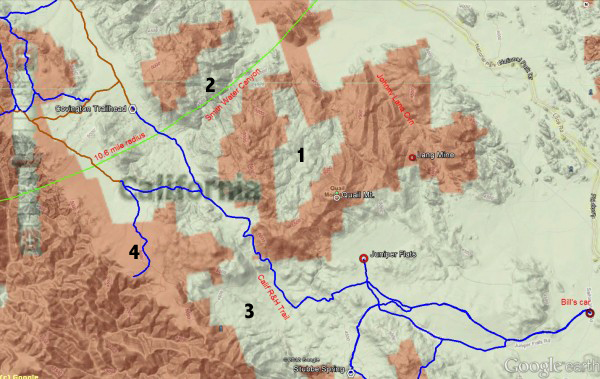
Bill's car is parked on the extreme bottom right. Quail Mountain is roughly in the middle. "1" is the cell dead zone between Quail Mountain and SWC, "2' is SWC itself, "3" is the area northwest of Stubbe Spring, and "4" is Upper Covington (where there is no cell coverage, contrary to what this map says, other than at certain spots on the extreme western escarpments). The blue lines are existing trails. In my experience they are fairly accurate around the SWC area but overstated around UC. The SWC "magic bullet" spot I have talked about is at the thinnest band of brown lying between the white areas marked by "1" and "2".
So you see the problem; how is Bill out for 2 1/2 days without hitting a trail and/or a cell tower? This is another reason I was looking at Upper Covington so hard; it was easier to reconcile with those facts. It looked pretty good, but getting him into UC was pretty hard to do, because you can see the road anywhere you enter from the south or east, with one exception - and on that exception, he would have had to jog into more difficult terrain and somehow miss a trail that was just a few feet away.
Thoughts?
There's another wrinkle to consider, though. Bill's phone pinged just after sunrise on Sunday but not before. So that means that Bill's phone was working and still had at least enough battery to boot up from the time he left the trailhead Thursday to that point. The other problem with Smith Water is it means he's in a fairly enclosed space (perhaps 2 miles x 2 miles) for two plus days where there's no cell reception, then once he breaks into a cell area (and there just aren't many on the 10.6 line), he vanishes in an area that's been pretty heavily searched.
Be that as it may, one presumes that Bill is trying to get a phone call out as soon as he gets in trouble, presumably by 7 or 8 p.m. Thursday night. Here's a map from Tom's website, which in turn is borrowed from Verizon's site and I think Google maps, on which I overlaid the four possible places he most likely was at that time (the brown areas are Verizon's stated coverage areas):
Bill's car is parked on the extreme bottom right. Quail Mountain is roughly in the middle. "1" is the cell dead zone between Quail Mountain and SWC, "2' is SWC itself, "3" is the area northwest of Stubbe Spring, and "4" is Upper Covington (where there is no cell coverage, contrary to what this map says, other than at certain spots on the extreme western escarpments). The blue lines are existing trails. In my experience they are fairly accurate around the SWC area but overstated around UC. The SWC "magic bullet" spot I have talked about is at the thinnest band of brown lying between the white areas marked by "1" and "2".
So you see the problem; how is Bill out for 2 1/2 days without hitting a trail and/or a cell tower? This is another reason I was looking at Upper Covington so hard; it was easier to reconcile with those facts. It looked pretty good, but getting him into UC was pretty hard to do, because you can see the road anywhere you enter from the south or east, with one exception - and on that exception, he would have had to jog into more difficult terrain and somehow miss a trail that was just a few feet away.
Thoughts?
- adamghost
- Posts: 57
- Joined: Tue Jun 23, 2015 12:47 pm
Return to Outdoors-Related Topics
Who is online
Users browsing this forum: No registered users and 0 guests