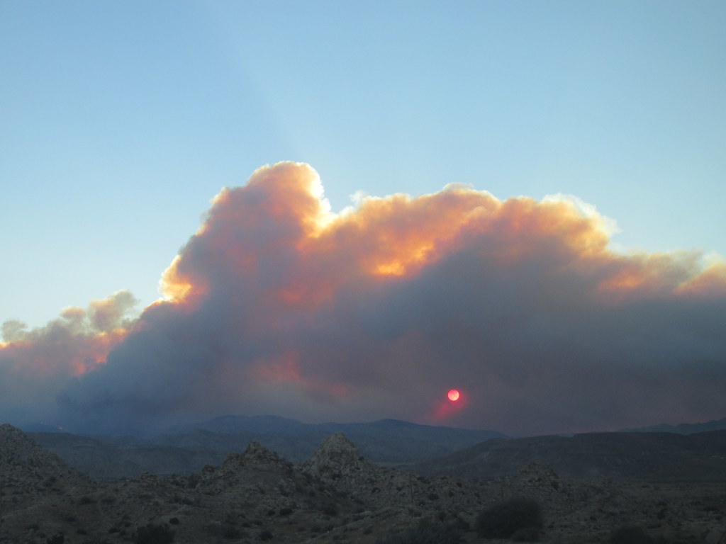
Lake Fire (Barton Flats)

Southern California and far-away places. Hiking, wildlife, cycling etc.

Re: Lake Fire (Barton Flats)

Postby Ellen » Wed Jun 24, 2015 11:24 am

I haven't posted much recently due to being very sad about this destructive fire in the San Gorgonio wilderness.

Thanks for the updates on this tragedy.

I cannot adequately express how much we have all lost :cry: I also weep for all creatures great and small affected by the fire.

Pi-- thanks for the lovely bobcat photos.

From the heart,
Ellen

Ellen
 
Posts: 2578
Joined: Thu Mar 29, 2007 9:38 am
Location: Riverside, CA

Re: Lake Fire (Barton Flats)

Postby Robert Hunt » Wed Jun 24, 2015 12:28 pm

I've no words for this loss so early in the season. The view from the Toro Pk webcam: http://hpwren.ucsd.edu/cameras/L/tp-n-mobo-c.jpg
Robert Hunt
 
Posts: 55
Joined: Thu Oct 24, 2013 3:10 pm

Re: Lake Fire (Barton Flats)

Postby zippetydude » Wed Jun 24, 2015 1:08 pm

User avatar
zippetydude
 
Posts: 2751
Joined: Tue May 09, 2006 5:40 am

Re: Lake Fire (Barton Flats)

Postby Hikin_Jim » Wed Jun 24, 2015 1:19 pm

I fixed the original link. Thanks for the link, Robert. It shows a lot, and I mean a lot, of smoke in the upper Whitewater River drainage which is consistent with what the maps are saying. The North Fork appears to now be burning out of control. The downside is that it will be very hard to keep it from climbing up to the tarn, Bighorn Peak, and San Gorgonio Mountain. :cry: The possible upside is that maybe all that gawdawful brush in the lower North Fork will be cleared. In addition the old Big Tree Track may now become useable.

HJ
Backpacking stove reviews and information:  Adventures In Stoving
Personal hiking blog: Hikin' Jim's Blog
User avatar
Hikin_Jim
 
Posts: 4958
Joined: Mon Oct 30, 2006 9:12 pm
Location: Orange County, CA

Re: Lake Fire (Barton Flats)

Postby Pitownpi » Wed Jun 24, 2015 1:59 pm

Critters haven't had a problem with the brush in North Fork....and I'm happy it was less traveled!
can NOT see wanting IT to burn it so I can walk around easy! :|
...and blog about it! :wink:

1400...really taking off in the little/big morongo canyons around 3 sisters...I mean wow!
Image

this is looking at the 3 sisters ridge, morongo canyons are south/north (left/right)
Image

Fire going down North Fork and Up Bighorn now.
Image

Bighorn up in smoke....somewhat
Image

1400 Video
Image

14:50 6/24/2015...can see active fire now spreading north & north east out of morongo canyon towards Onyx Summit
Image

1700 6/24/2015
Winds picked up to gusting from S & SW 30 and over since noon (and building) and this station only around 6-7kft.
everytime I look in that direction today, was shocked.

http://www.wrh.noaa.gov/mesowest/getobext.php?wfo=sgx&sid=BCNC1&num=48&raw=0

and fire has gone quite a bit further north & east, looks like its approaching Onyx
was surprised to see active flames now a week later between 3 Sisters & Pipes & Onyx Summit.
the numbers must have gone to over 20,000 ac, and containment less than 38%?

Asked for 2 large tankers and have requested a type 3 ST.
Sounds like it is making some movement on the highway 38 side.
Per South Ops Type 1 Team being activitated - California IMT 5 (Minton)
Image

Video
Image
Pitownpi
 
Posts: 152
Joined: Sat May 15, 2010 8:41 am

Re: Lake Fire (Barton Flats)

Postby Hikin_Jim » Wed Jun 24, 2015 5:40 pm

Pi's statement that the fire may be taking a turn for the north may be all too correct. They've ordered the evacuation of Camp Oakes in the "Lake Williams" area. The camp is east of Deadman Lake and west of the PCT. The camp is definitely on the north side of Onyx summit. If they're evacuating area, that's not a good sign.

HJ
Backpacking stove reviews and information:  Adventures In Stoving
Personal hiking blog: Hikin' Jim's Blog
User avatar
Hikin_Jim
 
Posts: 4958
Joined: Mon Oct 30, 2006 9:12 pm
Location: Orange County, CA

Re: Lake Fire (Barton Flats)

Postby Pitownpi » Wed Jun 24, 2015 6:53 pm

Yup!
just what I thought.. :-(
Image
Pitownpi
 
Posts: 152
Joined: Sat May 15, 2010 8:41 am

Re: Lake Fire (Barton Flats)

Postby zippetydude » Wed Jun 24, 2015 7:13 pm

Yeah, you can see the huge horrible plume from Redlands and Yucaipa, looks like a bomb went off. I hate this.

z
User avatar
zippetydude
 
Posts: 2751
Joined: Tue May 09, 2006 5:40 am

Re: Lake Fire (Barton Flats)

Postby Hikin_Jim » Wed Jun 24, 2015 8:22 pm

The Forest Service issued an order closing the entire SGW, including those areas not affected by the fire, until October 1, 2015. Closure map on my blog.

HJ
Backpacking stove reviews and information:  Adventures In Stoving
Personal hiking blog: Hikin' Jim's Blog
User avatar
Hikin_Jim
 
Posts: 4958
Joined: Mon Oct 30, 2006 9:12 pm
Location: Orange County, CA

Closure Map issued a week after start is out of date...

Postby Pitownpi » Wed Jun 24, 2015 8:28 pm

Closure Map from the source!
http://inciweb.nwcg.gov/photos/CABDF/2015-06-17-1915-Lake-Fire/picts/2015_06_24-16.53.57.084-CDT.pdf

the fire is off the map today after the map was finally anointed by someone and released!
doesn't cover the northerly progress towards Onyx...

Image

Image

Image

Image

Image
Pitownpi
 
Posts: 152
Joined: Sat May 15, 2010 8:41 am

PreviousNext

Return to Outdoors-Related Topics

Who is online

Users browsing this forum: Bing [Bot] and 2 guests