Hello, I made an image with google earth with a proposed route up to this little peak in Anza-Borrego. Has anyone walked up this way? Can I just walk up the ridge to the top or is the surface too rough/rocky? I have not really done any off-trail hiking in the desert but this might be a good start since it is not way back in the hills or anything.
Thank you

Mt. San Jacinto Outdoor Recreation
Hiking, Climbing, Camping, Trail Running, Snowshoeing...
Has anyone taken this route near Hellhole Canyon?
14 posts
• Page 1 of 2 • 1, 2
Has anyone taken this route near Hellhole Canyon?
![]() by backpackpack » Thu Mar 05, 2015 10:16 am
by backpackpack » Thu Mar 05, 2015 10:16 am
- Attachments
-
- route
-
backpackpack - Posts: 106
- Joined: Wed Sep 25, 2013 4:18 pm
Re: Has anyone taken this route near Hellhole Canyon?
![]() by Florian » Thu Mar 05, 2015 7:00 pm
by Florian » Thu Mar 05, 2015 7:00 pm
I've not actually been to that peak but looking at topo map looks like it's the WEBO benchmark. I would go up the ridge coming up from the east. Not as steep and you can also pick up the TED benchmark on the way.
-Florian
-Florian
-

Florian - Posts: 1441
- Joined: Sat May 16, 2009 4:49 pm
- Location: Palm Springs
Re: Has anyone taken this route near Hellhole Canyon?
![]() by Florian » Thu Mar 05, 2015 7:11 pm
by Florian » Thu Mar 05, 2015 7:11 pm
Make a loop and pick up the TUCK, KAY, and ODE benchmarks too. Looks like a neat hike. Might do it myself.

-Florian
-Florian
-
Florian - Posts: 1441
- Joined: Sat May 16, 2009 4:49 pm
- Location: Palm Springs
Re: Has anyone taken this route near Hellhole Canyon?
![]() by Florian » Thu Mar 05, 2015 7:14 pm
by Florian » Thu Mar 05, 2015 7:14 pm
Not sure why the full map isn't showing. Here is link to image ..
https://dl.dropboxusercontent.com/u/75818/hellhole.png
-Florian
https://dl.dropboxusercontent.com/u/75818/hellhole.png
-Florian
-
Florian - Posts: 1441
- Joined: Sat May 16, 2009 4:49 pm
- Location: Palm Springs
Re: Has anyone taken this route near Hellhole Canyon?
![]() by barrelroll » Thu Mar 05, 2015 8:14 pm
by barrelroll » Thu Mar 05, 2015 8:14 pm
A few years back I did an overnight parking at Hellhole Canyon, going past the palm grove, then climbing up out of the canyon southward toward the campground along the highway. So I can't speak for the particular route you have in mind, but somewhat for the general area. The climb was difficult, but not excessively rocky, there was no climbing or scrambling involved, just a lot of self imposed switch backs. Hellhole Canyon itself does get a bit narrower and more difficult beyond the palms but not impassibly so.
I would agree that climbing the ridge past the "Ted" marker might be a more accessible route and also note that oftentimes the canyons tend to be more difficult than working your way up open ridges/hillsides. The canyons in that area tend to collect a lot of boulders making the route much more difficult/dangerous in many cases.
I would agree that climbing the ridge past the "Ted" marker might be a more accessible route and also note that oftentimes the canyons tend to be more difficult than working your way up open ridges/hillsides. The canyons in that area tend to collect a lot of boulders making the route much more difficult/dangerous in many cases.
- barrelroll
- Posts: 3
- Joined: Mon Oct 13, 2014 1:27 pm
Re: Has anyone taken this route near Hellhole Canyon?
![]() by jfr » Thu Mar 05, 2015 9:15 pm
by jfr » Thu Mar 05, 2015 9:15 pm
I've hiked the canyon up to the palms and Maidenhair Falls. Quite lovely. After the last rains it may be flowing nicely right now. That part of the desert got a half inch of rain last weekend.
As for bushwhacking up the slope, well, it'll probably be steep. Shouldn't be too difficult to avoid the occasional cholla and yucca as you climb. Stick to a ridge if possible, as the boulders get really huge down in the bottoms of the crevices and can make for a slow climb. There are a number of nice flat areas to camp just where the wash begins to open up, and you can see the lights of Borrego Springs at night from there.
As for bushwhacking up the slope, well, it'll probably be steep. Shouldn't be too difficult to avoid the occasional cholla and yucca as you climb. Stick to a ridge if possible, as the boulders get really huge down in the bottoms of the crevices and can make for a slow climb. There are a number of nice flat areas to camp just where the wash begins to open up, and you can see the lights of Borrego Springs at night from there.
My (collected) trip reports: http://hikingtales.com/
-
jfr - Posts: 145
- Joined: Sun Jul 12, 2009 11:10 am
- Location: 32N 117W
Re: Has anyone taken this route near Hellhole Canyon?
![]() by backpackpack » Sun Mar 08, 2015 2:02 am
by backpackpack » Sun Mar 08, 2015 2:02 am
Hello everyone!
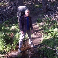
I did a recon hike up here today to see if I could do it with a pack. I must say, it was steeper than I thought. I did end up going the route up the ridge as Florian and others recommended, and I did see that Ted marker. What are those? I think it is something for USGS, I didn't know they were on maps though. That is neat. I ended up going about half way from the bottom of the slope to the peak because I started out later than I planned and it was about 3:00pm. I was concerned about snakes coming out seeking warmth so I headed back down.
I think I could make it to the top with a pack, but going down would be the hard part. There were some surprisingly steep climbs and it was all rock and crumbled rock. I would not want to slip and fall on the way down with a 50 pound pack on my back and cacti all over. I don't know why my pack always ends up so heavy. A tent, pad, sleeping bag, little stove, pot, water, food. It doesn't seem like it should be that heavy. I think water is a large portion of the weight.
- Looking down
- Looking up
-
backpackpack - Posts: 106
- Joined: Wed Sep 25, 2013 4:18 pm
Re: Has anyone taken this route near Hellhole Canyon?
![]() by Sally » Sun Mar 08, 2015 7:53 pm
by Sally » Sun Mar 08, 2015 7:53 pm
I haven't any advice on this topic, backpackpack, but I did want to thank you for stirring up some memories of when my adult daughters and two very young (5 and 9?) grandsons went up as far as Maidenhair Falls a few years back. The highlights for the kids: tadpoles, ant-hills, weird hairy spiders, a Rosie boa, and cooling off in the Falls.
-

Sally - Posts: 1125
- Joined: Thu Sep 17, 2009 8:27 pm
- Location: Temecula
Re: Has anyone taken this route near Hellhole Canyon?
![]() by Hikin_Jim » Tue Mar 10, 2015 8:38 am
by Hikin_Jim » Tue Mar 10, 2015 8:38 am
Those are triangulation points that were used during the surveys of the area from which the maps were drawn. For whatever reason, in some parts of the country, they give triangulation points. Elsewhere they may receive some type of alphanumeric designation or no designation at all. For example, the triangulation point atop this summit has no designation.backpackpack wrote: I did see that Ted marker. What are those? I think it is something for USGS
Rule #1 with keeping pack weight down: Weigh everything. Put it in a spreadsheet. You'd be surprised what weighs what. Underwear? Quarter pound. Empty Nalgene? Quarter pound -- for the white ones. The clear, colored ones are even heavier. It all adds up. As Colin Fletcher once said, "take care of the ounces, and the pounds will take care of themselves".backpackpack wrote:I don't know why my pack always ends up so heavy. A tent, pad, sleeping bag, little stove, pot, water, food. It doesn't seem like it should be that heavy. I think water is a large portion of the weight.
HJ
Backpacking stove reviews and information: Adventures In Stoving
Personal hiking blog: Hikin' Jim's Blog
Personal hiking blog: Hikin' Jim's Blog
-

Hikin_Jim - Posts: 4958
- Joined: Mon Oct 30, 2006 9:12 pm
- Location: Orange County, CA
Re: Has anyone taken this route near Hellhole Canyon?
![]() by backpackpack » Tue Mar 10, 2015 8:56 am
by backpackpack » Tue Mar 10, 2015 8:56 am
Hikin_Jim wrote:Those are triangulation points that were used during the surveys of the area from which the maps were drawn. For whatever reason, in some parts of the country, they give triangulation points. Elsewhere they may receive some type of alphanumeric designation or no designation at all. For example, the triangulation point atop this summit has no designation.backpackpack wrote: I did see that Ted marker. What are those? I think it is something for USGSRule #1 with keeping pack weight down: Weigh everything. Put it in a spreadsheet. You'd be surprised what weighs what. Underwear? Quarter pound. Empty Nalgene? Quarter pound -- for the white ones. The clear, colored ones are even heavier. It all adds up. As Colin Fletcher once said, "take care of the ounces, and the pounds will take care of themselves".backpackpack wrote:I don't know why my pack always ends up so heavy. A tent, pad, sleeping bag, little stove, pot, water, food. It doesn't seem like it should be that heavy. I think water is a large portion of the weight.
HJ
That's a good idea. I think I definitely over-pack. Too much food, extra clothes, etc. I need to learn to let it go
I will lay out my gear this week and pretend I am packing for a trip and weigh everything and put it in excel. This should be interesting. Thanks for the suggestion.
-
backpackpack - Posts: 106
- Joined: Wed Sep 25, 2013 4:18 pm
14 posts
• Page 1 of 2 • 1, 2
Return to Mt. San Jacinto & Santa Rosa Mountains
Who is online
Users browsing this forum: No registered users and 5 guests