Mountain Fire -- More Exact Burn Maps

General Palm Springs area.

Mountain Fire -- More Exact Burn Maps

Postby Hikin_Jim » Sun Feb 22, 2015 4:40 pm

I was out on Monday hiking around. I could see that the actual burn area is far smaller than the official closure area. I'm wondering where the actual boundary of the burn is. I'm sure that the Forest Service has aerial photos.

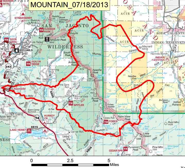
I wonder if there are any photos posted to the web anywhere? With aerial photos, it should be reasonable to come up with a good overlay to a topo map showing where the damage really is. The Mountain Fire Closure is a lot bigger than the actual burn area.

Here's what I saw when I went through the Burn area (legally!) on May Valley Road on Monday, 16 Feb 2015.

It's fairly narrow on the western side of the burn area. Here, you can see the burn area on the far side of Johnson Meadow:
Image

From the S Ridge Trail, you can see that the burn area widens a bit as it goes east:
Image

A zoom in on the top of South(well) Peak looks like the north face and the summit area burned. :( Rumor has it that the east side of the Desert Divide between Red Tahquitz and Antsell Rock got the worst of it.
Image

From Tahquitz Peak Lookout, South(well) and Antsell hardly look touched. The burn appears to be further south toward Apache and Spitler.
Image

Apache looks like it got toasted. Pyramid, Pine, and Lion look OK from this angle. Presumably things further south like Ken Point and Butterfly Peak are OK too.
Image

The burn area in the Garner Valley looks fairly confined.
Image

From the S Ridge Trail just west of the PCT Junction, there's no sign of fire at all in the Tahquitz Creek Drainage.
Image

HJ
Backpacking stove reviews and information:  Adventures In Stoving
Personal hiking blog: Hikin' Jim's Blog
User avatar
Hikin_Jim
 
Posts: 4958
Joined: Mon Oct 30, 2006 9:12 pm
Location: Orange County, CA

Re: Mountain Fire -- More Exact Burn Maps

Postby Hikin_Jim » Mon Feb 23, 2015 5:32 pm

Well, not from aerial photos, but this map squares pretty well with what I could see from the S. Ridge Trail and Tahquitz Peak:
Image

The widest extent was east of the Desert Divide.

HJ
Backpacking stove reviews and information:  Adventures In Stoving
Personal hiking blog: Hikin' Jim's Blog
User avatar
Hikin_Jim
 
Posts: 4958
Joined: Mon Oct 30, 2006 9:12 pm
Location: Orange County, CA

Re: Mountain Fire -- More Exact Burn Maps

Postby guest » Mon Feb 23, 2015 6:27 pm

Thanks for all of this Jim, it makes it easier to remain aware of these areas when we're treading across the San Jacinto's.
Sure hope they make rapid progress on reopening some spots, Like Curumba, Willow Ck & Cedar Spgs.

ss
guest
 
Posts: 804
Joined: Fri Oct 27, 2006 3:27 pm

Re: Mountain Fire -- More Exact Burn Maps

Postby Florian » Mon Feb 23, 2015 7:14 pm

Hi Jim. I think maybe your last photo is a bit misleading. You can't see any fire evidence from where you took that photo but there was fire in Tahquitz Creek drainage. You can see from Wellman Divide and from the bit of the Caramba trail that is still open east of Saddle Junction and also from Tahquitz Peak fire lookout. I think you are aware of that but i just wanted to clarify that the fire did burn into Tahquitz Valley.

-Florian
User avatar
Florian
 
Posts: 1439
Joined: Sat May 16, 2009 4:49 pm
Location: Palm Springs

Re: Mountain Fire -- More Exact Burn Maps

Postby Hikin_Jim » Tue Feb 24, 2015 8:46 am

I didn't see any signs of a burn in the Tahquitz Creek drainage, but that doesn't mean that there aren't any. Particularly people who have been up along Hidden Lake Divide have posted photos of fire damage. The map I posted above clearly shows that the fire did penetrate into the Tahquitz Creek drainage, particularly to the east.

HJ
Backpacking stove reviews and information:  Adventures In Stoving
Personal hiking blog: Hikin' Jim's Blog
User avatar
Hikin_Jim
 
Posts: 4958
Joined: Mon Oct 30, 2006 9:12 pm
Location: Orange County, CA

Re: Mountain Fire -- More Exact Burn Maps

Postby Florian » Wed Feb 25, 2015 7:28 pm

Good map and map animation here ..

http://www.pcta.org/2013/mountain-fire- ... pct-13236/

-Florian
User avatar
Florian
 
Posts: 1439
Joined: Sat May 16, 2009 4:49 pm
Location: Palm Springs

Re: Mountain Fire -- More Exact Burn Maps

Postby Hikin_Jim » Wed Feb 25, 2015 8:39 pm

Excellent animation. I guess I can see why from where I was I couldn't see any burn evidence in the Tahquitz Valley area.
Backpacking stove reviews and information:  Adventures In Stoving
Personal hiking blog: Hikin' Jim's Blog
User avatar
Hikin_Jim
 
Posts: 4958
Joined: Mon Oct 30, 2006 9:12 pm
Location: Orange County, CA

Re: Mountain Fire -- More Exact Burn Maps

Postby recordalley » Mon Mar 09, 2015 5:59 pm

FYI, just talked to the forest service in Idyllwild & closure won't be re-evaluated till next fall, so closure will be in effect throughout the summer.
Get out of that damn contraption & walk!
--Edward Abbey
User avatar
recordalley
 
Posts: 156
Joined: Wed Jun 02, 2010 4:25 pm
Location: Palm Desert

Re: Mountain Fire -- More Exact Burn Maps

Postby Hikin_Jim » Wed Mar 11, 2015 7:25 am

No surprise there. A lot of the stuff in Garner Valley is pretty much ready to be re-opened from what I could see. The trail from the Herkey Creek area that connects to May Valley Road. There's really no reason that should be closed while May Valley Road is open. There may be some burnt trees, but it's not so heavily forested in there that falling limbs from burnt out trees is going to be a significant hazard.

HJ
Backpacking stove reviews and information:  Adventures In Stoving
Personal hiking blog: Hikin' Jim's Blog
User avatar
Hikin_Jim
 
Posts: 4958
Joined: Mon Oct 30, 2006 9:12 pm
Location: Orange County, CA

Re: Mountain Fire -- More Exact Burn Maps

Postby K & W » Wed Mar 11, 2015 9:44 am

Sorry state of affairs anyway if public lands managers are concerning themselves with public safety from natural hazards (and user error for that matter) - it'll be all over then. I hope it opens sooner than later, but while it's closed I sure hope it is not closed as a matter of public safety.
K & W
 
Posts: 7
Joined: Wed Mar 11, 2015 9:24 am

Next

Return to Mt. San Jacinto & Santa Rosa Mountains

Who is online

Users browsing this forum: Google [Bot] and 33 guests