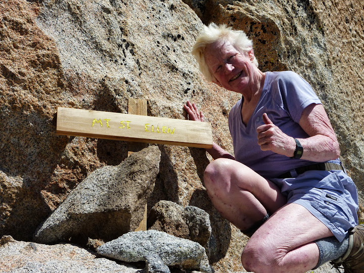
Being as I missed the birthday party of the year last Saturday when a bunch of Ellen's friends just happened to "bump" into her on the trail and surprised her even further by giving her a peak and naming it after her, I had a strong desire to see this peak for myself. Ellen was quick to oblige by guiding me up there for our weekly Wednesday Wandering. I think she was looking forward to seeing it again, this time without rain.
So we headed up the Marion Mountain Trail to the Deer Springs Trail, and a short way up we headed off trail in an easterly direction. At first the route was fairly unobstructed by brush and rocks, and I was thinking it was a piece of cake. Eventually we started running into a few obstacles, but there was actually a use trail and even a few cairns, so we felt we were on the right track.
We were at the base of some bump that seemed like it was Mt St Ellen and headed up. At one point I zipped on the lower part of my convertible pants and Ellen donned tights because the brush was getting deep. We shimmied up rocks and came to a sort of impasse. Ellen explored to the right and found only a clump of VW sized boulders. She informed me that it didn't look like we could get through. I explored to the left, and much to my disappointment I found only boulders the size of school buses. Our only choice was to go back down a bit.
We wound around the bump and as we got to the east side a flat area came into view, and across from it there was another peak that we ascertained to be Marion, so we headed across and up. I wasn't expecting it, but as I rounded a boulder, there was a sign! Mt. St. Ellen! Well dang, we were ready for lunch, and this was a lovely spot.
Whilst lunching, we were thinking that maybe the first peak we were on was The Rockpile and maybe we were perhaps on Marion Mtn. Hmmm... We did a little exploring of the area before heading down.
We skirted the mountain by going south and then back around on its east side and then crossing a broad flat area. We were now ready to head back over to the Deer Springs Trail and chose to go down the Deer Springs drainage rather than take the longer route to Little Round Valley. We met up with the trail and took it down. When we got to the CCC camp, we found ourselves in their camp, oops. Sorry guys, but they have made many little side trails off the main trail and I guess we were yakking so much that we accidently got off on one of them.
After getting back on track the rest of the trip was uneventful and we reached our cars and had celebratory beverages. We went back to Idyllwild and had great burgers at Joanne's.
It was a wonderful day, and even if Ellen's peak isn't in the place where it was intended to be, we like it just where it is. It really is a gorgeous spot!
Pictures:
https://picasaweb.google.com/1009477359 ... directlink

Mt. San Jacinto Outdoor Recreation
Hiking, Climbing, Camping, Trail Running, Snowshoeing...
Mt. St. Ellen Revisited
10 posts
• Page 1 of 1
Mt. St. Ellen Revisited
![]() by Sally » Sat Sep 14, 2013 8:38 am
by Sally » Sat Sep 14, 2013 8:38 am
-

Sally - Posts: 1125
- Joined: Thu Sep 17, 2009 8:27 pm
- Location: Temecula
![]() by Hikin_Jim » Sat Sep 14, 2013 7:48 pm
by Hikin_Jim » Sat Sep 14, 2013 7:48 pm
That's very cool that you guys were able to find the spot where we placed the marker. The dirty little secret of that day is that we didn't exactly put the marker on the right spot (not really all that close either)  I mean it's in the vicinity, but if you went to the geographical top of Mt. St. Ellen's you wouldn't see the marker.
The place where we put it was a cool little spot though -- a flat clearing. I was quite surprised to find flat clearing up there among the rocks and brush.
I must say it looks better without lightning and rain.
HJ
The place where we put it was a cool little spot though -- a flat clearing. I was quite surprised to find flat clearing up there among the rocks and brush.
I must say it looks better without lightning and rain.
HJ
Backpacking stove reviews and information: Adventures In Stoving
Personal hiking blog: Hikin' Jim's Blog
Personal hiking blog: Hikin' Jim's Blog
-

Hikin_Jim - Posts: 4958
- Joined: Mon Oct 30, 2006 9:12 pm
- Location: Orange County, CA
Re: Mt. St. Ellen Revisited
![]() by HH8 » Mon Sep 16, 2013 5:23 am
by HH8 » Mon Sep 16, 2013 5:23 am
Sally wrote: there was a sign!
That's gotta be the best bday gift ever. Well done gentle-persons.
Wish I'd been able to play with y'all.
- HH8
- Posts: 529
- Joined: Wed Aug 10, 2011 8:30 am
- Location: San Diego
![]() by Ulysses » Mon Sep 16, 2013 7:06 am
by Ulysses » Mon Sep 16, 2013 7:06 am
Hikin_Jim wrote: The dirty little secret of that day is that we didn't exactly put the marker on the right spot (not really all that close either) :lol: I mean it's in the vicinity, but if you went to the geographical top of Mt. St. Ellen's you wouldn't see the marker.
It must be well hidden. I was up there yesterday. Topped out and spent the better part of an hour hunting around for the sign and register. Never found it. I was worried that the State had removed it, so I'm relieved to learn that it's in a not so obvious place.
Happy belated birthday and congratulations to Ellen. I was looking forward to signing the register.
Brett
- Ulysses
- Posts: 279
- Joined: Mon May 03, 2010 6:16 pm
- Location: Idyllwild
![]() by Hikin_Jim » Mon Sep 16, 2013 8:01 am
by Hikin_Jim » Mon Sep 16, 2013 8:01 am
That's why I'm kind of surprised that Ellen and Sally found it so easily.
It was raining and lightning was zapping about. We wanted to summit and get out. In our haste, we made some nav errors, and we didn't even try to get the highest point. There was a lot of brush and rock, so when we came upon the perfect little clearing, voila, that became Mt. St. Ellen's.
The actual location is on the flanks of Marion Mountain -- on the ridge that proceeds west from Marion's western summit. Um, like I say, we really weren't all that close to the true summit of Mt. St. Ellen's. I'd say we were closer to Marion's western summit.
HJ
Backpacking stove reviews and information: Adventures In Stoving
Personal hiking blog: Hikin' Jim's Blog
Personal hiking blog: Hikin' Jim's Blog
-
Hikin_Jim - Posts: 4958
- Joined: Mon Oct 30, 2006 9:12 pm
- Location: Orange County, CA
![]() by Ellen » Mon Sep 16, 2013 5:14 pm
by Ellen » Mon Sep 16, 2013 5:14 pm
Howdy All
I confess that for quite a while, I was seriously worried that I wouldn't even be able to find the "peak" named in my honor

On that extraordinary day, I was a state of happy bliss following my friends and we were enveloped in clouds. Our group was actually so spread out that at one point I yelled "Marco!" to which more than dozen voices replied "Polo!"
I'm looking forward to returning and doing more exploring
Miles of smiles,
Ellen
I confess that for quite a while, I was seriously worried that I wouldn't even be able to find the "peak" named in my honor
On that extraordinary day, I was a state of happy bliss following my friends and we were enveloped in clouds. Our group was actually so spread out that at one point I yelled "Marco!" to which more than dozen voices replied "Polo!"
I'm looking forward to returning and doing more exploring
Miles of smiles,
Ellen
- Ellen
- Posts: 2578
- Joined: Thu Mar 29, 2007 9:38 am
- Location: Riverside, CA
![]() by Hikin_Jim » Mon Sep 16, 2013 8:38 pm
by Hikin_Jim » Mon Sep 16, 2013 8:38 pm
Precision navigation at it's finest.Ellen wrote:at one point I yelled "Marco!" to which more than dozen voices replied "Polo!"
Note to those new to the backcountry: Advanced techniques like these are best left to the experts, like, um, Ellen.
HJ
Backpacking stove reviews and information: Adventures In Stoving
Personal hiking blog: Hikin' Jim's Blog
Personal hiking blog: Hikin' Jim's Blog
-
Hikin_Jim - Posts: 4958
- Joined: Mon Oct 30, 2006 9:12 pm
- Location: Orange County, CA
![]() by towbradley » Mon Sep 16, 2013 9:42 pm
by towbradley » Mon Sep 16, 2013 9:42 pm
Leave it to the experts is right. I made the trek from deer springs to San j summit solo on Saturday, and it was amazing. But to go off trail would be suicide for me. As for the San j. Peak, it was beautiful, but no sign was there at the top for my pic. I'll just have to do it again. Met some very nice people up on the trail. Thought about the nice thing you guys did for Ellen as i passed through Marion to fuller trails. Saw my first mountain rattler also, but unfortunately it looked like someone stabbed it. Thanks to sally for dialing me in on deer springs trail.am heading up to Nevada city this Friday, so if anyone has any simple trails to go on, let me know. My wife's going with me, so we thought we might do the humbug trail. Thirty years married. Should be a nice trip. Also, a guy named Phil dropped his handkerchief on the way down, so i hope to meet up with him and his hiking partner again.
- towbradley
- Posts: 106
- Joined: Sat Apr 13, 2013 10:23 pm
![]() by Sally » Tue Sep 17, 2013 7:33 am
by Sally » Tue Sep 17, 2013 7:33 am
Congrats, towbradley! So sorry that the summit sign had been ripped off for your first summit of San Jacinto because getting your picture in front of it is part of the whole experience. (The sign was still missing on Sunday when Ellen and I were up there)
Also, congrats on 30 years married. Have fun in Nevada City!
Also, congrats on 30 years married. Have fun in Nevada City!
-
Sally - Posts: 1125
- Joined: Thu Sep 17, 2009 8:27 pm
- Location: Temecula
![]() by Ardiner » Wed Sep 25, 2013 2:56 pm
by Ardiner » Wed Sep 25, 2013 2:56 pm
Hikin_Jim wrote:The place where we put it was a cool little spot though -- a flat clearing. I was quite surprised to find flat clearing up there among the rocks and brush.
HJ
I was back up on Sunday retracing our hike up to see if I could find my lost lens. No luck on the lens but the view from the flat clearing as great on this clear day. I think that for a while until a path through the chinquapin is worn it will not be an easy find as you have to do a small amount of rock scrambling and bush wacking as you get to the area with the marker. I'm thinking that many will try to approach more from the ridgeline down from Marion. I was originally going to take a side trip to Marion but realized it was later than I thought and I'd already get back to the trailhead at dark. While I was considering it I went up toward the summit blocks but did not see a straight forward way to approach the clearing from the summit. That clearing is a great place to take in the views and eat before heading back down or on to other destinations. Unfortunately I was not thinking or I would have printed a the group dedication shot and placed it in the register box.
-
Ardiner - Posts: 24
- Joined: Fri May 07, 2010 11:02 am
10 posts
• Page 1 of 1
Return to Mt. San Jacinto & Santa Rosa Mountains
Who is online
Users browsing this forum: Baidu [Spider] and 6 guests