The Seven Summits of San Jacinto

General Palm Springs area.

The Seven Summits of San Jacinto

Postby Hikin_Jim » Mon Jul 08, 2013 4:59 pm

Well, I completed my July 5 through 7 backpacking trip in the San Jacintos -- with a few "slight" modifications.

I had made the "mistake" of carrying my daughter on a hike two days before my backpack. I say "mistake" not so much because it wasn't fun (it's very fun to take my daughter hiking) but rather because my daughter weighs 32+ pounds. Just imagine adding 15 liters of water over and above what you normally carry, and that's the weight of my daughter. Often she'll hike a fair distance on her own, but this was not to be on July 3rd. I carried her and all our gear, food, and water, probably around 55 lbs total (more than double what I would carry for a three day backpacking trip).

My daughter atop Echo Mountain near Altadena, CA:
Image

My legs were really tired when I started my backpack on Friday morning, and I had been up late on the 4th. I was moving like a sloth on a slow day.

So, rather than trying to get all the way to the vicinity of Willow Creek Crossing the first day, I stopped short at the edge of the North Rim Zone near the State Park boundary. I didn't do too badly in that I did go up a new (to me) cross country route and bag three peaks (Marion, Shirley, and Jean) and descend by another cross country route.

The next day, mindful of being tired, I decided on "Plan B" -- The Seven Summits of San Jacinto -- seven peaks in the San Jacinto Mountains all above 10,000 feet. Nice thing about the San Jacintos is that "Plan B" is still a pretty good trip. :) Here's a map of my route.

Now, I'm sure all the SAR guys reading this are cringing. Deviating from one's filed hike plan is bad. If one goes missing, there's no telling where one might be. But, rest assured, when I woke up Friday morning feeling very tired, I left my wife an email wherein I made mention of my "Plan B."

The Seven Summits are (by height) as follows below. The letters refer to the above linked map.
1. San Jacinto Peak ("R") - 10,834’ /3302m.
2. Jean Peak ("K") – 10,670’/3252m.
3. Folly Peak ("S") – 10,480+/3194m+ (no spot height available)
4. Miller "Peak" ("Q") – 10,400'+/3170m+ (no spot height available)
5. Shirley "Peak" ("J") - 10,388'/3166m (summit register says "LePake Peak" but Shirley Peak is the name commonly in use)
6. Marion Mountain ("I") – 10,362’/3158m
7. Newton Drury Peak ("V") – 10,160'+/3096m+ (no spot height available)

I put the word "peak" in quotes for Miller and Shirley peaks since there is some question whether these little bumps are in fact truly peaks. However since these names are commonly used to describe these points, I use them here.

I'm still in the process of uploading the 452 photos I took. Full trip write up to follow.

Teaser photos for now:
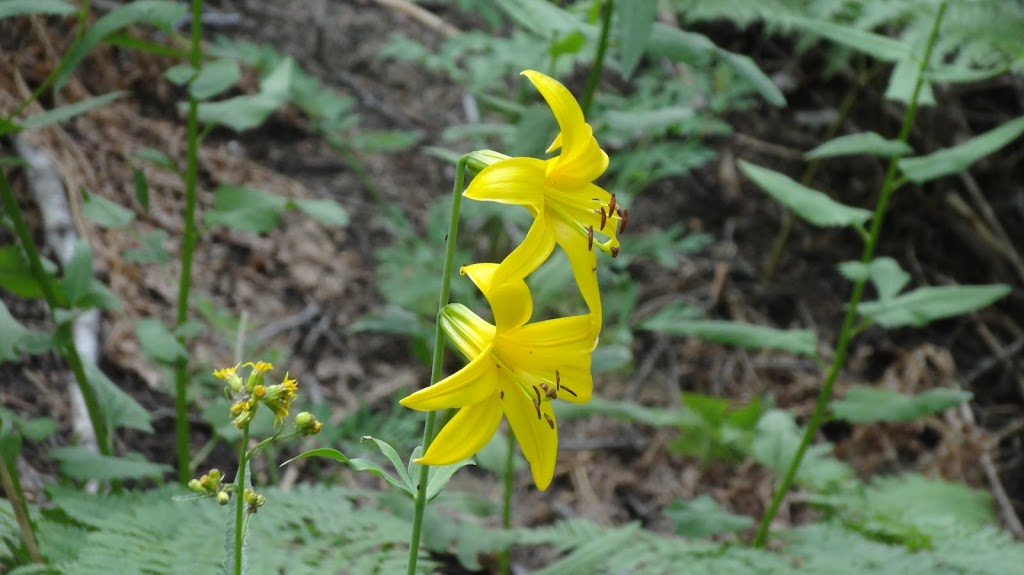
Lemon lillies (this is the height of the season, right now)
Image

Image

This is your climb on crack (Marion Mountain)
Image

Image

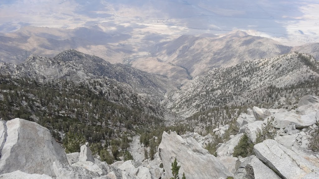
San Jacinto high country from Marion Mountain
Image

Tram Station from Miller Peak
Image

Folly Peak from San Jacinto
Image

Some creek on the north side of San Jacinto. Not that anyone would ever want to go there. ;)
Image

DWA water works (Dreaded Warren's Agency)
Image

San Jacinto from Folly
Image

San Jacinto high country from Folly
Note: "The Rockpile" is my name for this formation and is not necessarily a name of common use.
Image

"Backpacker's Gold" (water), Bed Springs (at the trail crossing)
Image

HJ
Backpacking stove reviews and information:  Adventures In Stoving
Personal hiking blog: Hikin' Jim's Blog
User avatar
Hikin_Jim
 
Posts: 4958
Joined: Mon Oct 30, 2006 9:12 pm
Location: Orange County, CA

Re: The Seven Summits of San Jacinto

Postby HH8 » Tue Jul 09, 2013 5:00 am

Hikin_Jim wrote:my daughter weighs 32+ pounds.


Mighty dainty for her age - you are so blessed!

Tram Station from Miller Peak
Image


killer zoom - what did you take it with?
HH8
 
Posts: 529
Joined: Wed Aug 10, 2011 8:30 am
Location: San Diego

Postby Ulysses » Tue Jul 09, 2013 6:38 am

Great pictures HJ. Thanks for posting. Especially like the Lemon Lillys. The annual lemon Lilly Festival is being held in Idyllwild this coming weekend.
Ulysses
 
Posts: 279
Joined: Mon May 03, 2010 6:16 pm
Location: Idyllwild

Postby zippetydude » Tue Jul 09, 2013 11:39 am

Nice TR HJ. My goodness how Joyce has grown. She's a little girl now instead of a baby. BTW did you do the whole thing xc?

z
User avatar
zippetydude
 
Posts: 2751
Joined: Tue May 09, 2006 5:40 am

Postby Hikin_Jim » Tue Jul 09, 2013 3:54 pm

zippetydude wrote:Nice TR HJ. My goodness how Joyce has grown. She's a little girl now instead of a baby.
Yep, she's getting to be a big girl now. She can even open the car door and the front door. :shock:

BTW did you do the whole thing xc?
I used the Seven Pines Trail to get into the general vicinity. From Deer Springs Crossing, I did an XC route to Marion, then XC to Shirley and Jean Peaks and then XC down to Wellman Divide.

My next XC route was from Miller Saddle to Miller Peak, then up the old East Ridge Trail to San Jacinto Peak. Then XC down the west ridge of San Jac to Folly. From Folly, I traversed XC to Drury Saddle and then up to Newton Drury.

Map:
Image

The section down from San Jac Pk to Folly Pk Saddle is mostly class two and is one of the most fun routes in the San Jacintos. Amazing views to the north.

HJ
Backpacking stove reviews and information:  Adventures In Stoving
Personal hiking blog: Hikin' Jim's Blog
User avatar
Hikin_Jim
 
Posts: 4958
Joined: Mon Oct 30, 2006 9:12 pm
Location: Orange County, CA

Postby arocknoid » Tue Jul 09, 2013 9:00 pm

Thanks for the TR, pix, and H2O update Jim.

Glad your plan B worked out well, and the legs recovered.

Looking forward to more of your photos and prose with the full TR.
(no doubt some gastronomic teasers, too.)

kind regards,
arocknoid
User avatar
arocknoid
 
Posts: 342
Joined: Thu Aug 26, 2010 11:36 pm

Postby bluerail » Tue Jul 09, 2013 9:20 pm

Looks like you've been having fun Jim, there's some fun out there off trail.
User avatar
bluerail
 
Posts: 2108
Joined: Thu Dec 11, 2008 10:30 am
Location: La Quinta

Re: The Seven Summits of San Jacinto

Postby Hikin_Jim » Wed Jul 10, 2013 12:36 am

HH8 wrote:
Tram Station from Miller Peak
Image
killer zoom - what did you take it with?
Sony Cybershot, model DSC-HX30V. Fabulous camera. Does well on zoom or macro. Same camera I had on the Desert Divide.

HJ
Backpacking stove reviews and information:  Adventures In Stoving
Personal hiking blog: Hikin' Jim's Blog
User avatar
Hikin_Jim
 
Posts: 4958
Joined: Mon Oct 30, 2006 9:12 pm
Location: Orange County, CA


Return to Mt. San Jacinto & Santa Rosa Mountains

Who is online

Users browsing this forum: No registered users and 6 guests