Amen Jim! Work & Family sure get in the way of my outdoor adventures too. But I wouldn't change a thing.
Awesome photos! Can't wait for the full TR! Maybe get your hiking co- conspirators to help out with the TR?

Mt. San Jacinto Outdoor Recreation
Hiking, Climbing, Camping, Trail Running, Snowshoeing...
Desert Divide?
43 posts
• Page 5 of 5 • 1, 2, 3, 4, 5
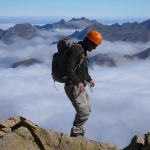
![]() by Hikin_Jim » Fri May 31, 2013 1:22 pm
by Hikin_Jim » Fri May 31, 2013 1:22 pm
Here's our final route map.drndr wrote:Nice pics HJ. But what kind of HJ TR is this without some links to maps. I love your detailed maps.
We skipped Cone and Palm View due to lack of time and opted out of Red Tahquitz in the interests of getting home in a more timely fashion.
We got water on day one at Tunnel Spring, water on day two at Scovel Cr (not named on map) above Fobes Ranch, water on day three from a water cache carried in by trail angel Hal, and water on day four from Tahquitz Cr.
We camped on day one just south of Lion Peak (Point "I"), day two at Scovel Cr. (near point "Q"), day three in the Little Tahquitz area.
Photo: Entering the San Jacinto Wilderness just north of Fobes Saddle.

HJ
Backpacking stove reviews and information: Adventures In Stoving
Personal hiking blog: Hikin' Jim's Blog
Personal hiking blog: Hikin' Jim's Blog
-

Hikin_Jim - Posts: 4958
- Joined: Mon Oct 30, 2006 9:12 pm
- Location: Orange County, CA
![]() by Hikin_Jim » Fri May 31, 2013 1:52 pm
by Hikin_Jim » Fri May 31, 2013 1:52 pm
It's a good one, Perry. For a trail runner, you might be able to do it in a day. If you just stuck to the PCT and the Devil's Slide Trail, it would be 28 miles on the PCT + 2.5 miles on the DST for a total of 30.5 miles with about 9200 feet of gain and 7600 feet of loss. The gain and loss numbers are rough numbers; the actual numbers are probably a little higher.Perry wrote:You've inspired me to do this someday...
The real issue might be water. We carried 6+ liters from Tunnel Spring on day one. I basically ran out of water on day three (which was included Antsell Rock and was particularly grueling). Fortunately, we bumped into jfr on the trail, and he gave me 0.75L which got me through the remainder of the day.
Caching of course could eliminate some of the hardship. There are multiple side trails that intersect the PCT:
Cedar Spring Trail
Spitler Peak Trail
Fobes Ranch Trail
Apple Canyon Trail
Each of these side trails could be used to cache water in advance and make the route far more commodious.
The views along the Desert Divide are outstanding.

HJ
Backpacking stove reviews and information: Adventures In Stoving
Personal hiking blog: Hikin' Jim's Blog
Personal hiking blog: Hikin' Jim's Blog
-
Hikin_Jim - Posts: 4958
- Joined: Mon Oct 30, 2006 9:12 pm
- Location: Orange County, CA
43 posts
• Page 5 of 5 • 1, 2, 3, 4, 5
Return to Mt. San Jacinto & Santa Rosa Mountains
Who is online
Users browsing this forum: Baidu [Spider] and 4 guests