OtherHand wrote:I still like the concept of that area as it addresses so many of the elements of the case, more so than anywhere else.
Yeah, and if not there, where?
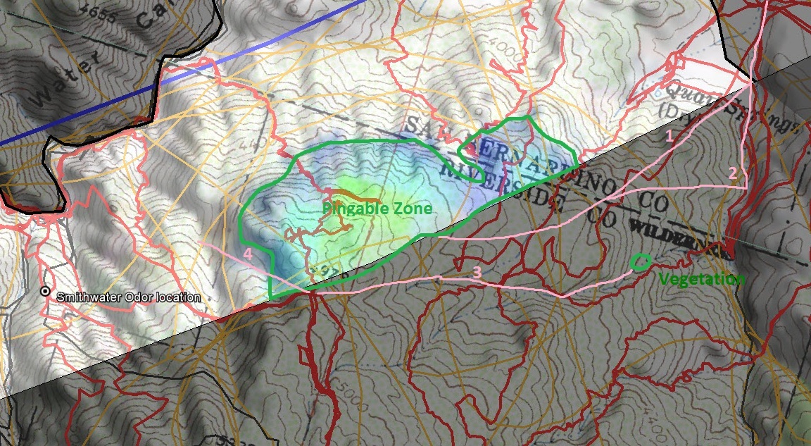
You've got a fairly good probable zone of location: The intersection of the cell phone coverage from the Serin Drive tower and the measured distance of the ping, what I call the "pingable" zone. Again, I refer to your graphic (click to enlarge), with a few added markings:

On Sunday morning, there's a strong chance that Bill was in that pingable zone. But his cell phone failed. Where then does he go? There are several possible scenarios:
1. The
"lay down and die" scenario. At this point, Bill is so spent that when his cell phone dies, he simply lays down and dies. While possible, I rate this one as a
low probability. First, it's just not Bill, and second if he's got the strength to crawl to a high point to try to find cell coverage, it's unlikely that he's going simply going to give up. Besides that if he were up on the ridge in the pingable zone, he'd probably have been found by now.
2. The
"descent into Smith Water" scenario. Bill finally decides on the fourth day out to attempt the descent to the bottom of Smith Water. I rate this one as
low probability. Why is Bill still up on the high ground between Quail and Smith Water if descent is a possibility? Put another way, what's changed where he now has the strength and ability to descend into rugged Smith Water that he didn't have the day before? It doesn't make sense that he perforce stayed stayed up top but only now decides to descend, and not only descend, but try to descend into a rugged place like Smith Water. It just doesn't wash.
3. The
"hunker down" and take shelter scenario. Somewhere up there, he's found a place with some shade, and on Friday and Saturday, he's holed up. On Sunday, he tries his cell phone, the cell phone dies, Bill crawls back to his sheltered spot, and sometime thereafter meets his demise. I rate this one as a
moderate probability. Discussion: I was able to find a sheltered spot on my trip into Smith Water from Quail. Notice in the below photo that I'm in the shade of a scrub oak:

As OtherHand points out, his stuff should be scattered by now, but still, I think it's worth thinking about where he may have gone if he chose to take shelter. What might he have seen on his way in from Quail? Where has he been the whole time on Friday and Saturday?
4. The
"exit to the east" scenario. He goes up to Pt. 4979 on Sunday morning. What might he have seen from up by Pt. 4979? Perhaps he saw the flats and ridges that extend towards and to the east of Quail Springs. Perhaps from his vantage point, it looked like a real option, one that he wouldn't necessarily have seen coming from the east given the comparatively steep eastern wall of the gully that bounds the flats on the east. I rate this one as a
moderate probability, but lower than the "hunker down" scenario. Again, if he had the ability to get off the high ground between Quail and Smith Water, he would have done so by now. Perhaps, however, the view to the east persuaded him that he could do it even though injured.
So, we've got four possible scenarios, two low probability, two moderate. None are high probability; we just don't have enough in my mind to call anything high probability. With any of the scenarios, one still has to ask why we haven't found Bill yet.
Further comments:
I drew in some routes on the above graphic in
pink. Routes 1 & 2 are possible routes that fit with the "exit to the east" scenario. There's been some good search coverage over there, but I wonder if there's anywhere over there still worth looking at.
Route 3 fits with the "hunker down" scenario. I can see fairly dense greenery on the satellite photo, and I can see that the greenery itself hasn't been searched (although there are two search tracks nearby). I don't know if this greenery is a) dense enough to explain why we haven't found Bill or b) accessible enough from the pingable zone for a presumably injured Bill to get to. Even if route 3 itself is bogus, the hunker down scenario is still a possibility; Bill could have found a rock with a steep north face, a properly aligned gully, or a solitary bush -- like the scrub oak I'm pictured under, above. I can very clearly see pockets of shade on the north side of rocks in satellite photos.
Route 4 fits with the "descent into Smith Water" scenario. Although I rate the descent scenario as low (why on earth would he wait until Sunday to start down?), Bill has so far defied all our reasoning, so perhaps. Of all the things one might see from the high ground above Smith Water, route 4 looks like the easiest descent. Perhaps he thought he could link up with the fairly prominent ridge between the odor location and the end of what I've marked as route 4.
Anyway, those are my thoughts for whatever they may be worth. I hope that one or two thoughts may be useful or at least stimulate further thinking and discussion.
HJ


