For what it's worth (think Zimbabwe dollars), here's my route for tomorrow. I estimate it at roughly a dozen miles. I have no intention of deviating from the route, but if I did it would be to bail out to the west back to the CR&HT. In the extremely unlikely event I had to hole up and wait for rescue, I would make every effort known to man to get to the aforementioned meat eating bushes in Smith Water (point "O") where there is at least some form of water. I carry a 406 MHz PLB, a whistle, a light, a Verizon cell phone, and a signal mirror.
I plan to do the majority of my searching around points "N" and "O". I probably won't travel in a straight line between the two points. I'm particularly interested in places that would be shielded from the morning sun. Bill's ping was detected early Sunday morning. Assuming he kept moving, he'd have been on the ridge that leads to Smith Water Canyon in the morning. It's possible that he crawled out of the sun... and never resumed crawling. This is part of why I thought glassing the area from the opposite ridge might be worth while (you'd be glassing in the opposite direction from the morning sun, looking directly at areas that would be sheltered from the sun in the morning hours). If possible, I'll hit points "K" and "M" which would be logical points from which to survey one's options on the descent. I consider these low probability, but since I'm there, why not?
Say a prayer for me... and for Bill's family and friends. Speaking from (very) personal experience, closure is a good thing.
HJ

Mt. San Jacinto Outdoor Recreation
Hiking, Climbing, Camping, Trail Running, Snowshoeing...
Story of missing hiker in Joshua Tree NP
![]() by Hikin_Jim » Thu May 17, 2012 4:51 pm
by Hikin_Jim » Thu May 17, 2012 4:51 pm
Backpacking stove reviews and information: Adventures In Stoving
Personal hiking blog: Hikin' Jim's Blog
Personal hiking blog: Hikin' Jim's Blog
-

Hikin_Jim - Posts: 4958
- Joined: Mon Oct 30, 2006 9:12 pm
- Location: Orange County, CA
![]() by thatoneguy » Thu May 17, 2012 6:15 pm
by thatoneguy » Thu May 17, 2012 6:15 pm
Hikin_Jim wrote:I estimate it at roughly a dozen miles.
looks like 10 miles with 3700ft gain
- thatoneguy
- Posts: 12
- Joined: Tue May 15, 2012 9:42 am
![]() by OtherHand » Thu May 17, 2012 7:25 pm
by OtherHand » Thu May 17, 2012 7:25 pm
That's a pretty substantial hike. Be aware that the last few hundred feet of descent into Smith Water get very steep in many places.
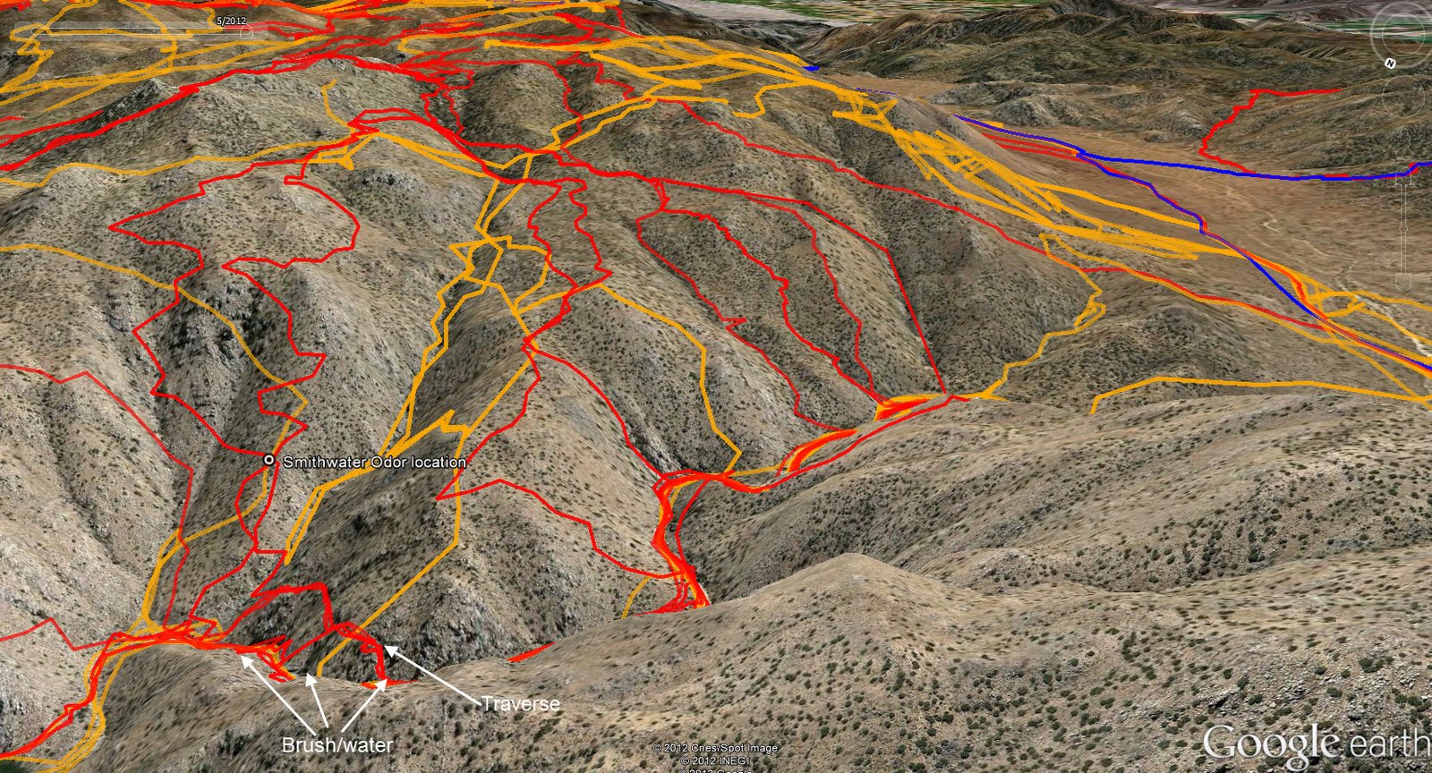
Perhaps this screen grab from a perspective view in GE might be of use to you, as there has been some coverage along your route. It doesn't look nearly that flat when you're on the ground! I marked in white where the bushes and water are, and you can see the traverse we used a couple of times on the southerly slope to get around it. The area above the traverse tracks is very steep, many cliffs. Because of this if you run down the ridge as you plan, you probably should fall off (bad word choice?) either to the east or west. If you do the east, you have to go through the brush.
http://www.otherhand.org/Stuff/SWperspective.jpg
The orange tracks in the canyon to the right of the odor location are the Sierra Madre tracks.
On the far right I drew in a track in red in one of the canyons for one of our guys who didn't have a GPS along. But that was his route.
Good luck....It will be an adventure. There's a good chance you'll see Big Horns. I think we've seen them in this area in about half the trips.
- OtherHand
- Posts: 291
- Joined: Mon Dec 28, 2009 2:07 pm
![]() by Hikin_Jim » Thu May 17, 2012 9:43 pm
by Hikin_Jim » Thu May 17, 2012 9:43 pm
Sierra Club HPS rates Quail and back at 10 mi, so I figured add a couple more mi to include Smith Water, but whatever. Whether 10 or 12, it's something on that order.thatoneguy wrote:Hikin_Jim wrote:I estimate it at roughly a dozen miles.
looks like 10 miles with 3700ft gain
HJ
Backpacking stove reviews and information: Adventures In Stoving
Personal hiking blog: Hikin' Jim's Blog
Personal hiking blog: Hikin' Jim's Blog
-
Hikin_Jim - Posts: 4958
- Joined: Mon Oct 30, 2006 9:12 pm
- Location: Orange County, CA
![]() by Hikin_Jim » Thu May 17, 2012 9:49 pm
by Hikin_Jim » Thu May 17, 2012 9:49 pm
Yeah, and with close to 2 gallons of water, I've got a pretty substantial pack to make up for it.OtherHand wrote:That's a pretty substantial hike.
West looks like the obvious choice. I'll look around up top, then go west to get to the bottom of Smith Water.OtherHand wrote:Be aware that the last few hundred feet of descent into Smith Water get very steep in many places.
Thank you.OtherHand wrote:Perhaps this screen grab from a perspective view in GE might be of use to you...
Now, that would be cool. And I am trying to make this "just" an adventure. I don't want to get my hopes up that I'll find anything. If I find anything, it'll be God's doing not mine.OtherHand wrote:Good luck....It will be an adventure. There's a good chance you'll see Big Horns. I think we've seen them in this area in about half the trips.
HJ
Backpacking stove reviews and information: Adventures In Stoving
Personal hiking blog: Hikin' Jim's Blog
Personal hiking blog: Hikin' Jim's Blog
-
Hikin_Jim - Posts: 4958
- Joined: Mon Oct 30, 2006 9:12 pm
- Location: Orange County, CA
![]() by zippetydude » Thu May 17, 2012 11:26 pm
by zippetydude » Thu May 17, 2012 11:26 pm
I just read this thread. I'm impressed. Interesting, with some considerable thinking involved. I have never participated in such a search, but hope to once my kids are grown. Of course, I'd like to be involved while there's still hope of finding someone while they're ok, but as HJ says, closure is a valuable thing in and of itself.
Good luck! Be sure to post if anything comes up.
z
Good luck! Be sure to post if anything comes up.
z
-

zippetydude - Posts: 2751
- Joined: Tue May 09, 2006 5:40 am
![]() by OtherHand » Fri May 18, 2012 10:07 am
by OtherHand » Fri May 18, 2012 10:07 am
zippetydude wrote:I just read this thread. I'm impressed. Interesting, with some considerable thinking involved. I have never participated in such a search, but hope to once my kids are grown. Of course, I'd like to be involved while there's still hope of finding someone while they're ok, but as HJ says, closure is a valuable thing in and of itself.
z
Zip, a big part of why I'm posting all the info on this is to allow anyone, such as yourself, to go out and look around. Getting full time into search and rescue is a lot of work, training and time. This is...something a little different. Bill is out there, somewhere. And beyond having the skills to be able to travel safely in remote spots (as many on this forum do), all that's required is to just go out there and hike. If people do this, Bill will be found. If no one does, he may never be found.
So far, I've failed 37 times at it. But each trip was interesting and I saw places and things I never would have otherwise. Journey versus destination sort of thing.
BTW, I just did the writeup on a trip I did yesterday. It was a lot of fun and I got myself into a place I didn't know existed.
- OtherHand
- Posts: 291
- Joined: Mon Dec 28, 2009 2:07 pm
![]() by zippetydude » Fri May 18, 2012 3:52 pm
by zippetydude » Fri May 18, 2012 3:52 pm
OtherHand wrote: all that's required is to just go out there and hike.
I totally agree. When my kids can't find something at home, I lead by example to teach them roughly the same lesson. I get up and join them, and we keep moving until we find what we're looking for. If a reasonable amount of time has gone by and we haven't found it, our rule is this: If we haven't found it yet and we've already scoured the area, it must be hidden by something else. (We're talking about a house, not a national park, of course.) Once we figure out that it's hidden from plain view, we usually find it within 5 - 10 minutes.
I bet you have general rules of how to look for clues (like observing an area from the east in the morning when the sun is at your back) that will help hone the search. If I head out that way to do some scouting in the fall, I'll hit you up for advice on how to best approach it and where to go. That is, if you're not successful by then.
z
-
zippetydude - Posts: 2751
- Joined: Tue May 09, 2006 5:40 am
![]() by Hikin_Jim » Sun May 20, 2012 7:15 pm
by Hikin_Jim » Sun May 20, 2012 7:15 pm
Well, I'm back home.
I had a good hike on Friday. The route I planned had been referred to as "substantial." lol. Yep, it was a pretty good little walk.
I did not find Bill though.
General impression: Pretty rugged terrain exists between the Quail Mtn area and Smith Mtn. The terrain to me is not inviting. If I were injured near Quail Mt and thinking "I'll head for water," one look at the terrain would dissuade me. And then once you get beyond the visible, it just gets worse: The terrain from the intervening saddle down to Smith Water is relatively challenging. The route finding is non-trivial.
In short, I can't imagine an injured person taking this route. If they did, they'd probably perish en route. The escape routes toward Quail Springs Road/Samuelson's Rocks look far more inviting, although none of these routes make much sense compared to the more obvious (in my mind) choice of just heading back to the car at Juniper Flats Trailhead. Cross country when injured? Really? That sounds like a really bad idea to me, but then I'm not Bill. There are plenty of cases of people deciding on a cross country route when injured in order to "get back quicker." It usually doesn't work out that way.
I'll write more later (I've got to get some freaking sleep!), but again I just can't imagine anyone who is injured getting to Smith Water. The terrain wasn't horrible, but I had two good legs, and I'm a pretty experienced map guy and route finder. If someone set out for Smith Water when injured, they'd never get there.
HJ
P.S. Definitely a good area to see Big Horn sheep

and wild flowers like this yucca bloom.

I had a good hike on Friday. The route I planned had been referred to as "substantial." lol. Yep, it was a pretty good little walk.
I did not find Bill though.
General impression: Pretty rugged terrain exists between the Quail Mtn area and Smith Mtn. The terrain to me is not inviting. If I were injured near Quail Mt and thinking "I'll head for water," one look at the terrain would dissuade me. And then once you get beyond the visible, it just gets worse: The terrain from the intervening saddle down to Smith Water is relatively challenging. The route finding is non-trivial.
In short, I can't imagine an injured person taking this route. If they did, they'd probably perish en route. The escape routes toward Quail Springs Road/Samuelson's Rocks look far more inviting, although none of these routes make much sense compared to the more obvious (in my mind) choice of just heading back to the car at Juniper Flats Trailhead. Cross country when injured? Really? That sounds like a really bad idea to me, but then I'm not Bill. There are plenty of cases of people deciding on a cross country route when injured in order to "get back quicker."
I'll write more later (I've got to get some freaking sleep!), but again I just can't imagine anyone who is injured getting to Smith Water. The terrain wasn't horrible, but I had two good legs, and I'm a pretty experienced map guy and route finder. If someone set out for Smith Water when injured, they'd never get there.
HJ
P.S. Definitely a good area to see Big Horn sheep
and wild flowers like this yucca bloom.
Backpacking stove reviews and information: Adventures In Stoving
Personal hiking blog: Hikin' Jim's Blog
Personal hiking blog: Hikin' Jim's Blog
-
Hikin_Jim - Posts: 4958
- Joined: Mon Oct 30, 2006 9:12 pm
- Location: Orange County, CA
![]() by Pitownpi » Mon May 21, 2012 9:14 am
by Pitownpi » Mon May 21, 2012 9:14 am
impressive sheep!
the one turned away has the largest horns I've ever seen!
and they are all gnarly and torn up!!!
covington flats is 20 minutes away from my cabin...
I hike there all the time looking/always searching for something on every and any hike!
the one turned away has the largest horns I've ever seen!
and they are all gnarly and torn up!!!
covington flats is 20 minutes away from my cabin...
I hike there all the time looking/always searching for something on every and any hike!
- Pitownpi
- Posts: 152
- Joined: Sat May 15, 2010 8:41 am
Return to Outdoors-Related Topics
Who is online
Users browsing this forum: No registered users and 4 guests