Storm system into the area later Thursday and into Friday ..

General Palm Springs area.

Postby zippetydude » Tue Nov 29, 2011 3:27 pm

HikeUp wrote:Spam goes good with humility.


Heh heh.

NOAA is calling for less than an inch on San J for Thurs and the same for Friday...

z

User avatar
zippetydude
 
Posts: 2751
Joined: Tue May 09, 2006 5:40 am

Postby TramWeatherCenter » Tue Nov 29, 2011 3:45 pm

zippetydude wrote:
HikeUp wrote:Spam goes good with humility.


Heh heh.

NOAA is calling for less than an inch on San J for Thurs and the same for Friday...

z


Not the official source for the tram jurisdiction and that number is way too low for the storm dynamics coming in. Plus not to mention saying that little snow for the type of pattern this system has is nothing more than dangerous and amateur.

I'm switching to Winter Storm Watch in 12 hours if trends continue.
TramWeatherCenter
 

Postby phydeux » Tue Nov 29, 2011 7:16 pm

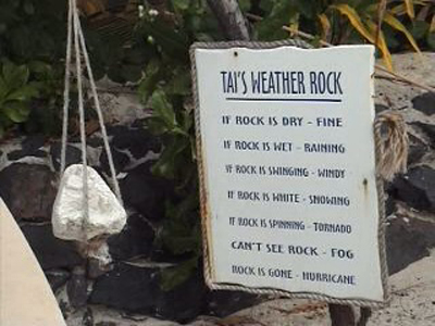
This is quite accurate, too:

Image
3 of the 5 voices in my head are telling me to "Go for it!"
User avatar
phydeux
 
Posts: 348
Joined: Sat May 13, 2006 5:32 pm
Location: Orange County, CA.

Postby bluerail » Wed Nov 30, 2011 7:29 am

You know when you call an orginization like noaa "amateur", your predictions are going to be closely watched and forever remembered.....snow to 1000' in places? Does this mean a good snowfall above 5000'?
User avatar
bluerail
 
Posts: 2108
Joined: Thu Dec 11, 2008 10:30 am
Location: La Quinta

Postby TramWeatherCenter » Wed Nov 30, 2011 8:55 am

bluerail wrote:You know when you call an orginization like noaa "amateur", your predictions are going to be closely watched and forever remembered.....snow to 1000' in places? Does this mean a good snowfall above 5000'?


Yes, snow ratios are high which means above 5,000 feet will have more snow. The systems are dynamic and another behind thu/fri's system is being watched.
TramWeatherCenter
 

Postby zippetydude » Wed Nov 30, 2011 12:32 pm

I'm afraid Phydeux's rock is still well ahead of Kevin's accuracy record. Sorry to say that Kevin, but that rock is amazing. Anyway, as they say in the South, didn't your mama teach you no manners? Amateur? Even if they're totally wrong and you happen to land a lucky guess, that's not professional on your part. Well, here's their forecast for near the peak of San Jacinto as of noon on Wednesday:

Thursday: A 30 percent chance of snow showers. Some thunder is also possible. Partly sunny, with a high near 22. Wind chill values as low as -10. Windy, with a north wind between 25 and 35 mph, with gusts as high as 70 mph. New snow accumulation of less than a half inch possible.

Thursday Night: A 30 percent chance of snow showers. Some thunder is also possible. Mostly cloudy, with a low around 12. Wind chill values as low as -10. Windy, with a north wind around 35 mph, with gusts as high as 70 mph. New snow accumulation of less than one inch possible.

Friday: A 40 percent chance of snow showers. Some thunder is also possible. Partly sunny, with a high near 28. Blustery, with a northeast wind around 25 mph, with gusts as high as 50 mph. New snow accumulation of less than a half inch possible.


So, that's less than two inches total predicted for San J, even at high elevations. Let's see if you can get a lucky shot on this one. If not, you should be willing to post: I Kevin Martin am just an amateur. Got the guts to back that up?

By the way, I watched your video. You do realize that your prediction doesn't actually cause the weather, don't you? By the way, just playin' here, don't go and get all sensitive on us.

z
User avatar
zippetydude
 
Posts: 2751
Joined: Tue May 09, 2006 5:40 am

Postby TramWeatherCenter » Wed Nov 30, 2011 1:07 pm

Way more than 2 inches. I'm for safety and that's it. If you want me to say that if it does not happen fine but this storm is one of those ones "they" will not forecast correctly to warn you guys.
TramWeatherCenter
 

Postby recordalley » Wed Nov 30, 2011 1:27 pm

The system has a pattern reminiscing November 2004

I remember that storm. Just got up 74 before they closed it. Scariest drive ever in the snow in my 4WD, almost slid into the side of the mountain. Over a foot of snow @ vista point & 2 feet at sugarloaf where the cafe was packed with people stuck waiting for the plows. Cars sliding all over the place on those curves. Don't think it snowed much at the tram though.
Get out of that damn contraption & walk!
--Edward Abbey
User avatar
recordalley
 
Posts: 156
Joined: Wed Jun 02, 2010 4:25 pm
Location: Palm Desert

Postby Funyan005 » Wed Nov 30, 2011 2:57 pm

This low looks to have no moisture attached to it, and all at the wrong levels.
Snow level to 1000 feet? Way more than 2 inches? I hope you're right but it's not likely from almost every model forecast
Funyan005
 
Posts: 11
Joined: Wed Aug 05, 2009 12:19 pm

Postby SoCalJim » Wed Nov 30, 2011 2:59 pm

I agree with KM on one point: Accuweather is unreliable and inaccurate, sometimes ridiculously so. But about his forecast for this weather pattern, all the PROFESSIONAL meteorologists (NOAA, TV meteorologists, etc.) are saying this will mainly be a cold and windy event without a lot of precipitation --- which doesn't mean the combination of strong wind plus cold temperatures is not hazardous for those unprepared in the backcountry.
SoCalJim
 
Posts: 80
Joined: Tue Feb 03, 2009 9:19 pm

PreviousNext

Return to Mt. San Jacinto & Santa Rosa Mountains

Who is online

Users browsing this forum: No registered users and 2 guests