I arrived at the picnic tables around 5:30, stopped to snap a few pics, and proceeded on. I passed a few people and I reached the 4300' marker around 7:30 am. There I decided to take a short break - eat some breakfast, apply sunscreen, etc. I hit the trail again around 7:50 and made pretty good time up to Flat Rock, arriving around 9:30. After here, the trail seemed to get quite a bit steeper. I looked at my GPS and it said I was about 100-150 ft off the trail. I didn't want to run into a dead end and have to turn around, so I set off the path to see if I could find the trail. I scouted around for about 30 minutes on some pretty sketchy hillside, but couldn't find anything. I heard a couple of hikers (Mike & Jacob) that I had passed earlier coming up the same way, so I decided to head back and meet them. Turns out, I was on the trail all along - my GPS had just gotten confused. After resetting my GPS app, everything seemed fine. But I decided to stick with Mike & Jacob for last 1500' or so, since this was Mike's 3rd trip. We reached Long Valley about noon.
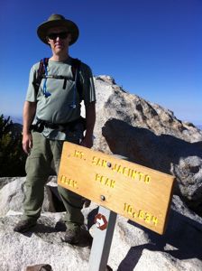
Jacob was looking a bit worn, but Mike convinced him to make the trek to the summit, so I decided to join them. After some well deserved rest, lunch, and filling out our permits, we headed out around 1:30 pm. Jacob was moving pretty slowly, but I didn't mind the relaxed pace, so I kept with them. We strayed off course a bit before we reached Wellman's Divide because of snow, but not too far. When we got there, Jacob decided he couldn't go any further, so Mike and I went on without him. The trail was mostly clear to the summit, with patches of snow here and there, until the last 50' or so, which required (at least for me) scrambling in the snow on all fours. I reached the summit at 5:00 pm, completely spent. I swear, if it had been 10' more, I might not have made it.

Mike headed back down to meet Jacob and I stayed at the summit for a little while to take some pictures and enjoy the view. But since I didn't have gloves, I couldn't stay too long - my hands were starting to go numb. On my way back down, I met up with another couple hikers I had seen earlier - a father & son (Mike & Matt) who were just making it to the summit. The trail was pretty easy to follow on the way down, but my knees were feeling it pretty good, and I was afraid of slipping in the snow, so I took it slow. Downhill always kills me. Mike & Matt (with their fancy trekking poles) passed me a little after Round Valley, and I met back up with them at the tram station around 8:15 pm. We split a cab back to the museum, and I headed to the Travelodge to get a bed.
All in all, I have to say it was a good trip. The weather was perfect. I didn't quite make the time I would have liked heading to the summit and back, but I made it, so I'm not complaining. I probably spent an hour or more futzing with my iPhone, taking tons of pictures and checking my GPS (I was live posting them to the internet so my friends could follow my progress, and so my mom would worry less about me going up solo). For my next trip, I am definitely going to try using trekking poles. Anything to make the downhill less tasking (I usually do downhills by taking big steps, leaping from rock to rock - that seems to be less stressful on my knees - but with the snow, it just didn't feel safe).
I'll also probably bring a little less water (I carried 6L of water and 1.5L of gatorade - next time I'm thinking 3 & 3). And I'll start earlier - maybe 3 am. I'd like to get a better view of Palm Springs before sunrise.
Thanks to everyone here for their expert advice. I am quite certain that without, my trip wouldn't have gone nearly as smooth, and there's a good chance I might not have made it at all.
-Chris