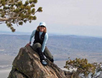
Last Saturday Dave G and i crossed our fingers that the Jenks Lake Road had been cleared of snow. We made our way up a beautiful and white Highway 38 to find our finger crossing had worked. The parking lot at the South Fork trailhead had even been plowed! With a few other hearty souls we enjoyed a day of snowshoeing. Breaking trail a lot of the day kept us from reaching our intended destination prior to our turn-around time. But my oh my, it was a perfect day of backcountry snowshoeing!
pix here: http://picasaweb.google.com/ryan.norma8 ... nGorgonio#
norma

Mt. San Jacinto Outdoor Recreation
Hiking, Climbing, Camping, Trail Running, Snowshoeing...
Snowshoe of Mount San Gorgonio 12/20/08
8 posts
• Page 1 of 1
Snowshoe of Mount San Gorgonio 12/20/08
![]() by NormaR » Wed Dec 24, 2008 12:41 am
by NormaR » Wed Dec 24, 2008 12:41 am
-
NormaR - Posts: 216
- Joined: Thu Dec 13, 2007 5:22 pm
- Location: Ventura County, CA
Snowshoe of Mt San Gorgonio 12/20/08
![]() by Cy Kaicener » Wed Dec 24, 2008 6:58 am
by Cy Kaicener » Wed Dec 24, 2008 6:58 am
Great pictures and trip report Norma. San Jacinto has the advantage of Rangers breaking trail  (as per Kathy's trip report.) Knowing Dave and yourself I bet you prefer doing the trailbreaking yourselves. That must have been quite a workout.
. Please visit my website at www.hiking4health.com for more information especially the Links.
http://cys-hiking-adventures.blogspot.com
http://cys-hiking-adventures.blogspot.com
-

Cy Kaicener - Posts: 2236
- Joined: Tue May 09, 2006 3:50 am
- Location: Rialto, California, USA
![]() by Hikin_Jim » Wed Dec 24, 2008 12:45 pm
by Hikin_Jim » Wed Dec 24, 2008 12:45 pm
Wonderful photos as usual Norma. Looks like you had a fabulous time.
Backpacking stove reviews and information: Adventures In Stoving
Personal hiking blog: Hikin' Jim's Blog
Personal hiking blog: Hikin' Jim's Blog
-

Hikin_Jim - Posts: 4958
- Joined: Mon Oct 30, 2006 9:12 pm
- Location: Orange County, CA
Pictures
![]() by lilbitmo » Thu Dec 25, 2008 12:17 pm
by lilbitmo » Thu Dec 25, 2008 12:17 pm
Great Pictures. Great TR
Love that side of the mountain, love that trail.
Since I always park at the Locked Gate (where Jenks Lk Road East meets West) have never seen the Horse Meadows Historic Buildings - can someone point me in the right direction to find them next time I'm up that way?
Lilbitmo
Love that side of the mountain, love that trail.
Since I always park at the Locked Gate (where Jenks Lk Road East meets West) have never seen the Horse Meadows Historic Buildings - can someone point me in the right direction to find them next time I'm up that way?
Lilbitmo
-

lilbitmo - Posts: 550
- Joined: Sun Feb 03, 2008 11:37 pm
![]() by Hikin_Jim » Thu Dec 25, 2008 2:06 pm
by Hikin_Jim » Thu Dec 25, 2008 2:06 pm
I think the gate you're refering to is the one that blocks the old road that lead to a parking area on Poop Out Hill. See point "A" on the map link
At approx. point "B," you'll see the remains of an old road heading left down to the old cabins at point "C." The cabins are somewhat interesting, but by the same token there's really not all that much to see.
Alternatively, if you miss the old road (at point "B"), it's no big deal. Just look for the S Fork Trail crossing the road. Turn left on this trail and walk down to the cabins.
If you come to a fairly sharp turn in the road where the road turns from E to N, then you've gone too far.
On snow shoes, it may well be eaiser to head up the old Poop Out Hill Road, but in snow/ice free conditions, I think the trail is more shaded and is a more scenic route. The trail goes fairly close to the cabins.
Backpacking stove reviews and information: Adventures In Stoving
Personal hiking blog: Hikin' Jim's Blog
Personal hiking blog: Hikin' Jim's Blog
-
Hikin_Jim - Posts: 4958
- Joined: Mon Oct 30, 2006 9:12 pm
- Location: Orange County, CA
Poopout Hill
![]() by lilbitmo » Thu Dec 25, 2008 3:51 pm
by lilbitmo » Thu Dec 25, 2008 3:51 pm
You are correct HJ it's the gate that the rangers and Forest Service guys use to get to the top of Poopout Hill. I've done San Gorgonio 5 times from this spot instead of the Trailhead parking because it was so easy for others to meet me there.
And since I've never done the lower second (below the road leading to the actual trial head) I've never come across the Cabins.
Thanks for the map and the location.
You feeling better yet?
I'm meeting some folks on Sunday for the second half of the Gabrielino Trial from Red Box down to JPL - you're welcome to join us if your feeling better?
By the way, since you live so close to that area, let me know what the snow elevation is tomorrow when all the snowing is done - want to make sure we are not bitting off to much?
The Caltrans webpage says the road is ok up to Mount Wilson road and by Sunday it should be even better?
Lilbitmo
-
lilbitmo - Posts: 550
- Joined: Sun Feb 03, 2008 11:37 pm
Re: Poopout Hill
![]() by Hikin_Jim » Fri Dec 26, 2008 1:22 am
by Hikin_Jim » Fri Dec 26, 2008 1:22 am
You're welcome of course.lilbitmo wrote:Thanks for the map and the location.
Better yes, but fully there yet. I went on a walk in the steep hills around my mom's house after Christmas supper today. My knee was really bugging me on the downhill, but it is greatly improved over where it was a couple of weeks ago. I'm encouraged.lilbitmo wrote:You feeling better yet?
Well, I haven't hiked for about a month now, and still I'm not 100% on the knee. Even if the knee were fully back, I'm pretty out of shape. Love to join you some time, but not this time.lilbitmo wrote:I'm meeting some folks on Sunday for the second half of the Gabrielino Trial from Red Box down to JPL - you're welcome to join us if your feeling better?
The clouds broke for a while earlier and I could see that the snow level was much higher than in the last storm. Also, my impression is that we got a lot less precipitation out of this storm than the last one. Those are my impressions, but I'll try to get a little better data for you tomorrow or Saturday.lilbitmo wrote:By the way, since you live so close to that area, let me know what the snow elevation is tomorrow when all the snowing is done - want to make sure we are not bitting off to much?
In terms of snow, if it's open to Mt. Wilson, I think you'd do fine from Red Box to JPL, but you still may run into ice. It's darn cold. Ice was forming on my car at 11:00 PM. Usually it happens later, in the wee hours of the morning. The section past Switzer's Trail Camp/Switzer Falls has some pretty steep drops. Ice would be bad. Keep your eye on the wx forecast.lilbitmo wrote:The Caltrans webpage says the road is ok up to Mount Wilson road and by Sunday it should be even better?
Backpacking stove reviews and information: Adventures In Stoving
Personal hiking blog: Hikin' Jim's Blog
Personal hiking blog: Hikin' Jim's Blog
-
Hikin_Jim - Posts: 4958
- Joined: Mon Oct 30, 2006 9:12 pm
- Location: Orange County, CA
![]() by Hikin_Jim » Sun Dec 28, 2008 10:08 pm
by Hikin_Jim » Sun Dec 28, 2008 10:08 pm
Check out this post on the San Gabriels forum re conditions around Mt. Wilson: http://sangabrielmnts.myfreeforum.org/sutra10864.php#10864
Backpacking stove reviews and information: Adventures In Stoving
Personal hiking blog: Hikin' Jim's Blog
Personal hiking blog: Hikin' Jim's Blog
-
Hikin_Jim - Posts: 4958
- Joined: Mon Oct 30, 2006 9:12 pm
- Location: Orange County, CA
8 posts
• Page 1 of 1
Return to Outdoors-Related Topics
Who is online
Users browsing this forum: No registered users and 0 guests