GPS

Reviews and discussion. For sale, wanted, trades, donations. Online deals.

Postby Hikin_Jim » Mon Nov 18, 2013 2:39 pm

climbant wrote:I believe all the new etrexs are able to use the Russian system and REI site says it does.

The big reason I do not care about the mapping feature on a GPS is because all I really want is that UTM reading. Documentation of the hike is nice also but that UTM is a nav savior sometimes. For my map I go paper, always.

If you do want to use a map on the GPS then the basic models are not gonna make you happy.
The UTM reading would probably be adequate, but it's faster for me to transfer points topo to topo, i.e. to see it on the topo snippet on the GPS and then transfer it directly to the paper topo map. A lot faster than doing the transfer by UTM coordinates, particularly since almost all of my printed maps do not have a UTM grid on them.

Where I might get in trouble is if I'm in an area where the topo features are either confusing or there's nothing distinctive about them. There I might need a UTM ruler and have to do plotting by coordinate.

HJ
Backpacking stove reviews and information:  Adventures In Stoving
Personal hiking blog: Hikin' Jim's Blog
User avatar
Hikin_Jim
 
Posts: 4938
Joined: Mon Oct 30, 2006 9:12 pm
Location: Orange County, CA

Postby climbant » Mon Nov 18, 2013 2:58 pm

From what I understand, the garmin maps aren't a perfect match to the USGS maps. What maps are you using that don't have a UTM grid? The UTM is very fast, I can even make a pretty close estimate just looking at the box, only using the ruler if I need to be as close as possible. On a 24K map and ruler you are looking at 10 meter accuracy.
climbant
 
Posts: 129
Joined: Fri Jul 19, 2013 10:50 am
Location: La Quinta

Postby Hikin_Jim » Mon Nov 18, 2013 3:03 pm

OtherHand wrote:I find the 1:100K maps useless. You can get subareas of the USA in the 24k series if you don't want to buy the entire country on DVD. Amazon sells a microSD card with all of California and Nevada already loaded on it for about $66. You can find the same thing on eBay for a little less.
Is it easier to use the microSD?

One thing that hasn't really been mentioned is the ability to export tracks and points from visual mapping products such as Google Earth. Many times I have come across interesting spots while perusing places in the middle of nowhere and can export them as KML files. There's a freeware/shareware program called GPS Babel that allows you to convert all sorts of waypoints and tracks between different mapping programs. This allows me to convert the GE kml files to Garmin's gdb file format. Once loaded into a GPS unit, finding it in the field is easy. This includes old mining roads that are visible on the air, but standing in the middle of it, on the ground, it's almost invisible.
Yeah, I dearly love the ability to toggle back and forth between satellite and topo views. I see that there's a Garmin package that comes with sat photos. That would be pretty nice.

There's a number of old trails, logging roads, and such that I'd like to follow that way.

HJ
Backpacking stove reviews and information:  Adventures In Stoving
Personal hiking blog: Hikin' Jim's Blog
User avatar
Hikin_Jim
 
Posts: 4938
Joined: Mon Oct 30, 2006 9:12 pm
Location: Orange County, CA

Postby Hikin_Jim » Mon Nov 18, 2013 3:07 pm

climbant wrote:What maps are you using that don't have a UTM grid?
Standard USGS quads. 7.5' series. 1:24,000.

climbant wrote:The UTM is very fast, I can even make a pretty close estimate just looking at the box, only using the ruler if I need to be as close as possible. On a 24K map and ruler you are looking at 10 meter accuracy.
Yep. Very familiar with the process. Was an Army guy in decades long past. Even taught map reading. I still have a 1:50,000 UTM "protractor" somewhere.

HJ
Backpacking stove reviews and information:  Adventures In Stoving
Personal hiking blog: Hikin' Jim's Blog
User avatar
Hikin_Jim
 
Posts: 4938
Joined: Mon Oct 30, 2006 9:12 pm
Location: Orange County, CA

Postby climbant » Mon Nov 18, 2013 5:06 pm

Wow, I have never bought a Quad that doesn't have the UTM grid, I even have a San Jac one that I bought in the early 90's that has it with a revised date of 81. I had no idea what a UTM was until a few years ago but all my topos have them. Thanks for your service also, hope you had a good Veterans Day.
climbant
 
Posts: 129
Joined: Fri Jul 19, 2013 10:50 am
Location: La Quinta

Postby OtherHand » Mon Nov 18, 2013 7:01 pm

Hikin_Jim wrote:
OtherHand wrote:I find the 1:100K maps useless. You can get subareas of the USA in the 24k series if you don't want to buy the entire country on DVD. Amazon sells a microSD card with all of California and Nevada already loaded on it for about $66. You can find the same thing on eBay for a little less.
Is it easier to use the microSD?


No matter what you need a memory card to load the maps on. If you buy a DVD of topo maps for the entire US you would still need a blank microSD card in the Garmin to put the maps on. Of course if you went that route you could get a large capacity card and put a lot more areas on it. But in addition to their DVDs Garmin also sells pre-loaded microSD cards for various parts of the country. So I suppose it's easier but not cost effective if you have interests in other states.
OtherHand
 
Posts: 290
Joined: Mon Dec 28, 2009 2:07 pm

Postby Hikin_Jim » Mon Nov 18, 2013 9:53 pm

climbant wrote:Wow, I have never bought a Quad that doesn't have the UTM grid, I even have a San Jac one that I bought in the early 90's that has it with a revised date of 81. I had no idea what a UTM was until a few years ago but all my topos have them. Thanks for your service also, hope you had a good Veterans Day.
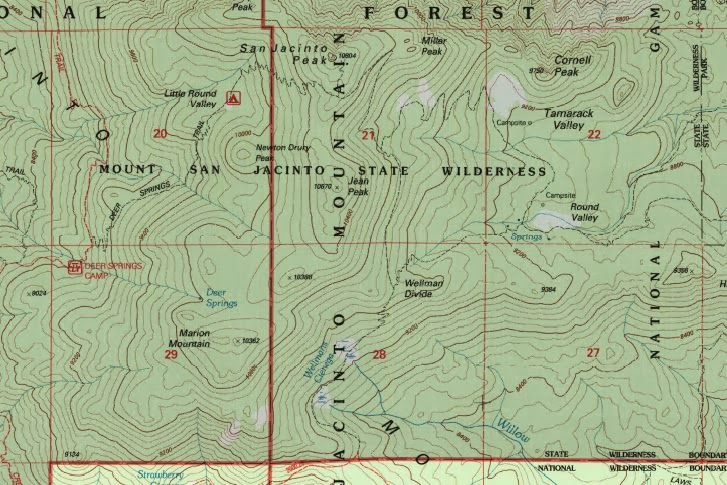
Does the grid on your map look like grid on the snippet below?
Image

HJ
Backpacking stove reviews and information:  Adventures In Stoving
Personal hiking blog: Hikin' Jim's Blog
User avatar
Hikin_Jim
 
Posts: 4938
Joined: Mon Oct 30, 2006 9:12 pm
Location: Orange County, CA

Postby OtherHand » Mon Nov 18, 2013 11:19 pm

Those are the Sections in the Township/Range legal description scheme. The UTM markers are on the edges of the maps, usually small black tick marks every 1,000 meters, and a very long number, the number being a coordinate. It's sort of like an X-Y coordinate system in meters. It's fairly handy if you're in the field and need to measure something. Because it's so useful with paper maps, it's historically been used heavily in SAR operations. That's starting to change a bit now due to the widespread saturation of GPS units.

Personally I find UTMs a bit of a pain in the butt. I'd rather deal with decimal lat/long coordinates. If you absolutely, gotta have UTM, most GPS units can be set to display them and even Google Earth can be set to provide UTM coordinates.
OtherHand
 
Posts: 290
Joined: Mon Dec 28, 2009 2:07 pm

Postby Hikin_Jim » Tue Nov 19, 2013 7:44 am

OtherHand wrote:Those are the Sections in the Township/Range legal description scheme.
Yes, exactly. I'm trying to establish exactly what grid he's seeing. I've seen a few USGS topos with the UTM grids printed on them, but very few. Usually, the grid you see on a USGS topo is the one mile square Township and Range sections. In the above snippet, I displayed sections 20 - 22 and 27 - 29 of the San Jacinto Peak 7.5' quadrangle.

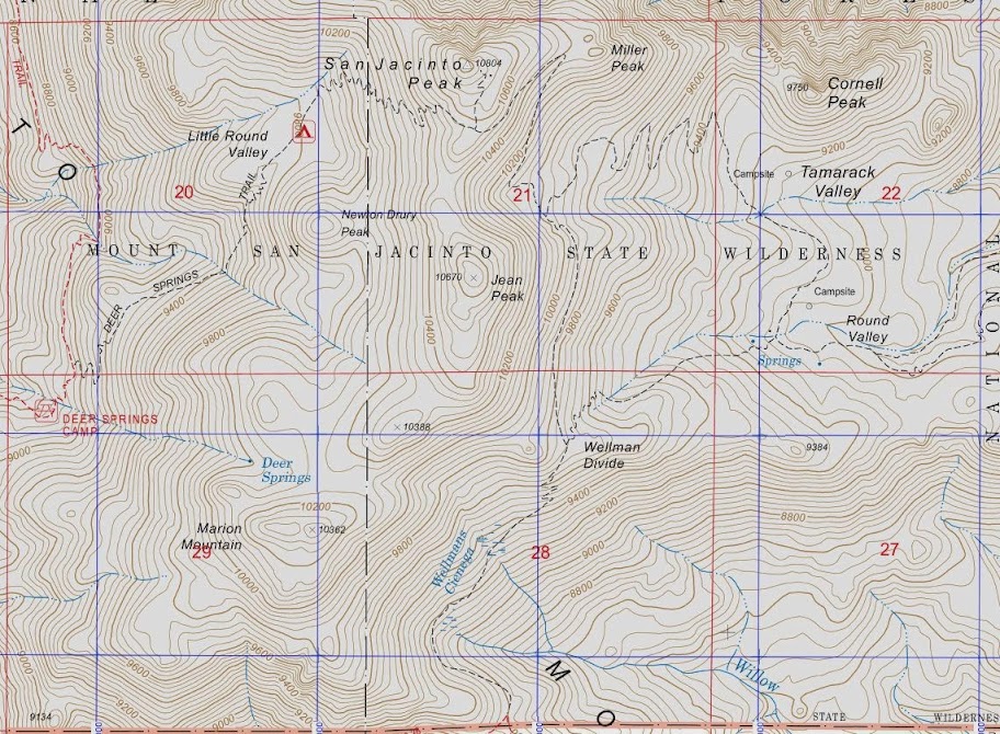
Below is a snippet with those same sections with the UTM grid on them, typically shown in blue on USGS maps.
Image

Again, I have seen some, but relatively few, maps from the USGS with the UTM grid pre-printed on the map. Nearly all, if not all, USGS topos have the UTM tick marks along the side, but those are pretty tough to do UTM coordinates from. You can also hand plot lat/lon, but that's a dicey proposition. You'll get in the ball park, but it's hardly precise.

Note on the immediately above map snippet that things get a little "busy" with both grids (UTM and survey sections). I think that's why most USGS maps don't show them.

Military maps on the other hand only show UTM. The military doesn't give a hang who's land it is. "I'm driving a main battle tank with a 120mm main gun. Your boundary matters to me, why?" :lol:

Personally, I'd rather have UTM grids on my maps than survey sections, but since the primary purpose of the US Survey was to produce survey sections for legal reasons, the section grids predominate. If you order printed maps from mytopo.com, I believe you can get civilian maps with UTM but without survey sections.

HJ
Backpacking stove reviews and information:  Adventures In Stoving
Personal hiking blog: Hikin' Jim's Blog
User avatar
Hikin_Jim
 
Posts: 4938
Joined: Mon Oct 30, 2006 9:12 pm
Location: Orange County, CA

Postby climbant » Tue Nov 19, 2013 10:56 am

Jim, I sent you an email with some pics from my phone. I really like getting my maps from mytopo because I can choose to only have a UTM grid on it and selecting the area you need no matter what quad its in is awesome. I rechecked all my USGS quads (not mytopo prints) and they all indeed have UTM grids.
climbant
 
Posts: 129
Joined: Fri Jul 19, 2013 10:50 am
Location: La Quinta

PreviousNext

Return to Outdoor Gear & Apparel, Food, Books

Who is online

Users browsing this forum: No registered users and 58 guests