Bill Ewasko found?

Southern California and far-away places. Hiking, wildlife, cycling etc.

Re: Bill Ewasko found?

Postby OtherHand » Tue Feb 15, 2022 10:36 pm

Hikin_Jim wrote:Personally, I'm starting to think that he really did descend Smith Water Canyon. He was still mobile on Sunday and in good enough shape to ascend to the ridges between Pts 4282 and 3976. He wasn't injured. It's about 16 to 17 miles from the Juniper Flats Backcountry Board to where Bill was located. A strong hiker could do that in a day, even with some cross country thrown in. Even if it took him two days to get there, he doesn't show up until the morning of the fourth day. Where's he been all this time? And why didn't he just back track as soon as he realized he was in trouble?
HJ


I've been pondering this for a while now, and I'm inclined to agree with HJ. A traverse from the Quail Ridge to Smithwater seems so off the wall as to be fantastical. But it's the only one of the three routes that really fits the circumstances.

If he was running low on water when he reached Quail or the ridge crest, and knew of the presence of water at Smithwater, he may have been tempted to proceed northerly, not knowing how bad that terrain is (It looks benign until you get into it). This is the sort of (bad) decision that could have been made on the fly.

If his cell phone was off, which is likely since he wasn't pinging towers all the way in to JTNP, there would be no need in his mind for him to make any emergency calls because he felt he knew what he was doing. So his phone stayed off. However, unless you know of the rather small area in Smithwater Canyon where the water actually is (And I'm fairly confident he didn't) it would be easy to make the descent into the canyon and miss it. By the time he realized there was no water, and not knowing where it was, it was too late. No cell coverage to call for help and a tremendous amount of energy and water expended to get there. It's clearly now a survival situation (it was earlier, he just didn't know it). The only reasonable option is to head easterly (downhill) to its junction with Quail Wash.

His decision tree from the Smithwater/Quail Wash junction get a bit murkier. If he had a map, and he presumably did and a sense of positional awareness, he should have known it was an easy run easterly across a flat, slightly uphill plain to Park Road a bit over 2 miles distant. Instead it appears he turned left, and proceeded downhill (northerly) in Quail Wash. This course would have eventually saved his butt since in around 3 miles he'd come to the park's boundary and there were homes. But this isn't visible until you get there and the area appears extremely remote.

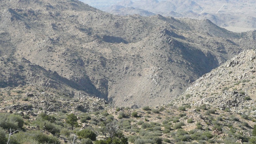
Unfortunately he didn't hold this course. For reasons I can't really fathom, after a short time in Quail Wash he made a right turn and started easterly up a broad canyon. This is the region where he would have pinged the Serin tower, his first cell phone connection. This canyon has a small use trail in it, but I don't think there is signage he'd see. I've been along this same course several times traveling just as he did. There's a point where the trail veers right and tops out of the right edge of the now narrower canyon. From here it's another straight shot across easterly the previously mentioned plain for 1.5 miles to Park Road.

But he didn't know to veer right, and stayed in the narrowing canyon bottom which curved left (northerly) and ran into high terrain to the north. He finally had an assfull of that and climbed the southerly side of the canyon to the saddle where he succumbed. I'm not sure why he kept climbing with so little energy unless he was trying to get a cell signal or he had no idea where he was.

As much as I don't really want to go back out to JT, I'm thinking I should, and recreate his route from the Quail Wash/Smithwater junction. I've travelled that route at least twice, but at those times I was in a preplanned search mode and not thinking about what would draw me in certain directions. It may have simply been dehydration, fatigue and stress that caused him to miss the required exit from the canyon he was travelling in. I recall it as being easy to miss, so maybe that's it. Dunno.

I must say that Bill's behavior as a "lost" hiker was one of the biggest outliers I've ever seen. He FAR exceeded any expectations of the people running the SAR operation. And that's not a good thing if you're trying to get yourself rescued. And by no means am I saying this as a hit to the SAR people. They did a great job, they just didn't know who they were dealing with. When the "this can't possibly be right" 10.6 mile ping surfaced, they reacted quickly and checked it out.

As for me, the only thing I've been right about is saying that if/when he's found, it will be someplace no one has thought of. Boy, is that not the truth...
OtherHand
 
Posts: 290
Joined: Mon Dec 28, 2009 2:07 pm

Re: Bill Ewasko found?

Postby jdclifford » Tue Feb 15, 2022 11:03 pm

That is Jim, thank you. I wouldn't imagine they'd turn my posts away because I'm not looking for a live person, but at least they might have suggestions for where I should post if so. I won't begin my searches until next fall, however, because I'm still healing from a triple ankle fracture in October. I've already started hiking, but not quite at searching mileage just yet.
jdclifford
 
Posts: 58
Joined: Sun Jan 19, 2020 11:48 pm

Re: Bill Ewasko found?

Postby Rumpled » Tue Feb 15, 2022 11:44 pm

I've never hiked on JT at all, but just looking at HJ's maps I gotta agree with HJ and Other hand.
So many nonsensical things though.
My dumb thoughts
He must not have crossed any roads or good trails or he would have taken them, right?
So how does he get from his car to where he was found? Veering off Quail My over to Smith Water seems to fit this.
Then, instead taking seemingly easier ways out of his predicament he heads up either for signal or thinking that would get him out.
Why does it take 3 + days to get there? Either he's got an injury that slows him but he can still push through slowly. Or, he hunkers down for a day or so because of dehydration etc and then makes that last effort.
I've read all these volunteer efforts over the years to solve this mystery and we still have almost as many questions.
We might get a few more answers, but probably not near enough.
User avatar
Rumpled
 
Posts: 122
Joined: Fri Jul 11, 2008 1:15 am

Re: Bill Ewasko found?

Postby Ed » Wed Feb 16, 2022 9:49 am

jdclifford wrote:I wasn't anticipating me and my friend basically spooning each other that night, but you gotta do what you gotta do to survive, right?


A technique also employed by Clarence King and Dick Cotter in 1864. They had identified Whitney as the highest mountain in the Sierras from the summit of Brewer, and were crossing the Sierras from west to east to climb it. Ended up on the summit of Tyndall, to the north of Whitney. In Mountaineering in the Sierra Nevada, King described climbing Tyndall from the west as a hair-raising vertical ascent, which it clearly is not. Later King tried to climb Whitney from the east, and ended up on the summit of Langley to the south. His Yale degree in geology did not make him a great cross-country navigator. Later he was the first director of the USGS, so perhaps he was better at cartography.

Sorry for the digression from Bill Ewasko. I do find the personal survival stories of contributors to be interesting, clearly the discussion of Bill is more than an intellectual exercise.
Ed
 
Posts: 824
Joined: Wed Oct 27, 2010 2:04 pm
Location: San Diego Area

Re: Bill Ewasko found?

Postby Hikin_Jim » Wed Feb 16, 2022 11:23 am

OtherHand wrote: A traverse from the Quail Ridge to Smithwater seems so off the wall as to be fantastical. But it's the only one of the three routes that really fits the circumstances.

Yes, and I'm equally guilty of mentally X'ing out Smith Water. After having done said traverse, I thought, "no way way would anyone normally do this with a late start, on a hot day, etc., etc." But of course Bill had not the advantage that I did of having previously done the traverse. The poor guy didn't know what he was getting into. Shooting off on a rugged cross country hike on the fly did not give Bill the opportunity that I had of careful map analysis with particular attention to the descent route.

Why all this blather about the descent route? Perhaps a picture is worth a thousand words. The below photo is from my approach to Smith Water Canyon. Note that you cannot see the bottom from from what is basically the lip of the canyon. It's freaking steep. I was a bit taken aback when I saw this -- even though I knew it was going to be steep. However, my nav was spot on, I stuck with my planned route, and I got down without incident. But of course I knew beforehand that hitting the right line was critical, and believe you me I was paying attention. I had detailed maps and a sighting compass. Heck yes I was shooting bearings down various gullies and comparing them to the angle of the gullies shown on the map. I realized from my map analysis that this would be a fairly committing route -- once down, even part way, there would be a HUGE disincentive to going back up. If nothing else, it would be exhausting. The real snare of Smith Water is that it starts out gentle enough, but once you're in, it gets steeper and steeper as you get close to the bottom. There are plenty of places where one could get basically "cliffed out," unable to descend and unwilling to backtrack. I can see it taking a long time to negotiate some approaches.

I've looked at that map many times since then. I'm convinced that my approach is the only good consistently class 1 descent route in the mid to upper section of Smith Water Canyon. I chose this route partly in hopes that Bill would also spot this "natural" approach. I now suspect that he did not take this approach (of course we still don't know for absolute sure that he even did the Smith Water traverse, but it sure is looking like he did). I suspect he "chose" something far harder. I put "chose" in quotes because, if going on the spur of the moment, he may have just taken a general westerly course. It's not like you can miss Smith Water Canyon. He more or less contoured across, probably going with the terrain.

I also did something "weird" in my route selection. I backtracked along the ridge that leads to Quail Mtn. On the high ground between the Quail Mtn ridge and Smith Water Canyon, the further north one goes, the rougher it gets. I saw this and wanted to traverse above the heads of each of the gullies leading north. Most hikers are not willing to back track. I suspect that Bill took a more northerly route for his traverse. The further north you go, not only is the terrain rougher, you're actually selecting a longer route. Think about it. As you cross each gully, you're either countouring back up gully to keep your elevation or you're dropping down and climbing back up. All this adds miles, difficulty, and time required. Bill could be quite spent, and it could be quite late when he finally reaches the edge of this:
Image

HJ
Backpacking stove reviews and information:  Adventures In Stoving
Personal hiking blog: Hikin' Jim's Blog
User avatar
Hikin_Jim
 
Posts: 4938
Joined: Mon Oct 30, 2006 9:12 pm
Location: Orange County, CA

Re: Bill Ewasko found?

Postby jdclifford » Wed Feb 16, 2022 2:37 pm

Ed wrote:A technique also employed by Clarence King and Dick Cotter in 1864.


Very cool, I always find that kind of history fascinating. Coincidentally, I have a great-uncle Dick (Richard) Cotter who lives in Calgary. No relation to the Dick Cotter you speak of, however, at least beyond distantly.
jdclifford
 
Posts: 58
Joined: Sun Jan 19, 2020 11:48 pm

Re: Bill Ewasko found?

Postby Ed » Wed Feb 16, 2022 3:26 pm

They were all members of the California Geological Survey. Whitney was the boss, Brewer was the chief of the field party, Clarence King and James Gardiner were members of the field party, Cotter was the mule skinner. They were into naming mountains after themselves.
Ed
 
Posts: 824
Joined: Wed Oct 27, 2010 2:04 pm
Location: San Diego Area

Re: Bill Ewasko found?

Postby jdclifford » Wed Feb 16, 2022 11:02 pm

I'm a pretty skeptical guy, but I've always been fascinated by the 1st session of the remote viewer notes on otherhand.org. How close do you guys believe this remote viewer got? If Bill was facing a certain way where he ended up, SWC would be a mile to his left. In that position, Twentynine Palms would be about 5 miles to his right. With his back facing the mountain, Samuelson Spur could be the rolling hills. You could fit a number of places within the previous search area to match up with the description in some shape or another, but it's interesting. Links to the 1st session of the remote viewer notes from Tom's website linked:

https://www.otherhand.org/wp-content/up ... Page_1.jpg
https://www.otherhand.org/wp-content/up ... Page_2.jpg
jdclifford
 
Posts: 58
Joined: Sun Jan 19, 2020 11:48 pm

Re: Bill Ewasko found?

Postby bretpct » Thu Feb 17, 2022 12:43 pm

How close they were just depends on how strictly you want to interpret their vague descriptions. Much like Nostradamus quatrains, these "viewings" don't have much predictive value but are easy to retroactively find things that they sorta describe. Sorry if I sound a bit harsh, but I really hope the family did not pay for these "viewings", or that SAR diverted any resources based on them. The part where it says the viewer "established contact" with Bill kind of disgusts me to be honest.
bretpct
 
Posts: 65
Joined: Mon Feb 13, 2017 2:40 pm

Re: Bill Ewasko found?

Postby OtherHand » Thu Feb 17, 2022 2:01 pm

I'm more than just a bit familiar with remote viewing, as well as notes derived from typical sessions. As a result, I've never put much weight in the stuff presented for Bill. Now that his location is known, it's clear this stuff wasn't even close, other than the "rocky hill" descriptions, but hey, it IS a desert, and the viewers likely knew that. Also, describing things to the right or left of a target is meaningless since it's dependent upon where one is facing. They had provided lat/long coords that were over toward Cap Rock or Ryan Campground, which I dutifully checked out, but again, not even close.

I also recall the report of some sort of psychic (separate from the remote viewers) who said Bill was no longer in Joshua Tree. Bzzzzt, wrong!

This stuff CAN work when performed by someone who is trained properly (and it's a lot of work!) and has some talent. But there are a great many wingnuts and/or wannabes in the field.
OtherHand
 
Posts: 290
Joined: Mon Dec 28, 2009 2:07 pm

PreviousNext

Return to Outdoors-Related Topics

Who is online

Users browsing this forum: No registered users and 9 guests