We will be having cooler temperatures as a result of a trough coming in. No moisture to support rain at all, and it will be generally clear on that mountain.
Saturday will be a nice day, with few high clouds around from the Southwest flow aloft and associate jet dynamics however even those are weak and cirrus will be widely scattered as lack of moisture in that level happens.
Sunday looks to be clearer however more Southwest flow in the upper/mid levels can bring a down a bit stronger winds from the Southwest across the mountain side 20mph gusts, with 30 mph being the top during the Afternoon/Evening. Weakening winds as jet dynamics weaken and move East of the area overnight.
Long range shows an amplification pattern which could mean colder air diving from the North. This would bring a storm system possible between September 19-22 stay tuned.
Kevin

Mt. San Jacinto Outdoor Recreation
Hiking, Climbing, Camping, Trail Running, Snowshoeing...
Hiking this weekend forecast 9/15 - 9/16
15 posts
• Page 1 of 2 • 1, 2
Hiking this weekend forecast 9/15 - 9/16
![]() by OntarioWeatherService » Thu Sep 13, 2007 4:23 pm
by OntarioWeatherService » Thu Sep 13, 2007 4:23 pm
www.ontarioweatherservice.com
Admin note: This is a private weather forecasting service and is not associated with National Weather Service or Ontario International Airport.
Admin note: This is a private weather forecasting service and is not associated with National Weather Service or Ontario International Airport.
-
OntarioWeatherService - Posts: 83
- Joined: Tue Sep 11, 2007 2:01 am
![]() by AlanK » Thu Sep 13, 2007 4:48 pm
by AlanK » Thu Sep 13, 2007 4:48 pm
Alternative local favorite Michael Mojarro says:
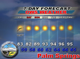
9/12/07: Temps today through Friday should be in the 70s below 8k and 60s above with lows overall in the 30s and 40s. Keeping a weary on on some monsoon moisture for the weekend but winds seem to be too strong out of the west in the upper levels to support much convection and temps too cool. Temps overall in the lower 60s on the peaks this weekend to around 70 below 8k. A strong trough of low pressure will bring a strong burst of fall next week with 40s and 50s likely for highs by Tuesday or Wednesday, right now snow or rain doesn't seem to occur but will be watching as a trough this strong this early could bring some surprises.
Sep 13, 2007: Look for a pretty warm day today with some inland valleys hitting or exceeding 100. Drastic cool down should begin its affects tomorrow into the weekend, and by next week we will have a taste of fall. Forecast will be delayed til this evening.
-

AlanK - Posts: 855
- Joined: Tue May 09, 2006 7:31 am
- Location: Glendale, CA
![]() by OntarioWeatherService » Thu Sep 13, 2007 4:51 pm
by OntarioWeatherService » Thu Sep 13, 2007 4:51 pm
I'd take what he says for a grain of salt. I had this in my forecast 1 week ago, 2 weeks before the storm would have showed.
"Upcoming events after today : Marine layer looks to return, and a cooling trend till the Weekend looks good.
Also, Long range OWS analysis shows a possible upper level low hitting the Western forecast area mainly. This will be a named storm if it continues on our progs by Mid September. "
I read would you would call a Rossby Wave. That to the effect he does not even know physics in weather forecasting. JUST MODELS.
A common mistake to anyone wishing to forecast.
Also, LMAO, he said warm day 100's in some Inland Valley locations!? That's not going to happen, and even I said no. Lets look at the real stats for his forecast.
www.ontarioweatherservice.com
Admin note: This is a private weather forecasting service and is not associated with National Weather Service or Ontario International Airport.
Admin note: This is a private weather forecasting service and is not associated with National Weather Service or Ontario International Airport.
-
OntarioWeatherService - Posts: 83
- Joined: Tue Sep 11, 2007 2:01 am
![]() by OntarioWeatherService » Thu Sep 13, 2007 5:09 pm
by OntarioWeatherService » Thu Sep 13, 2007 5:09 pm
Hottest valley location was 98, HEMET.
Corona 89
OWS forecast:
TEMPERATURES - Temperatures will be down a few degrees from yesterday.
Inland Empire will be in the 80's, with 90's in the hotter locations.
Corona 89
OWS forecast:
TEMPERATURES - Temperatures will be down a few degrees from yesterday.
Inland Empire will be in the 80's, with 90's in the hotter locations.
www.ontarioweatherservice.com
Admin note: This is a private weather forecasting service and is not associated with National Weather Service or Ontario International Airport.
Admin note: This is a private weather forecasting service and is not associated with National Weather Service or Ontario International Airport.
-
OntarioWeatherService - Posts: 83
- Joined: Tue Sep 11, 2007 2:01 am
![]() by OntarioWeatherService » Thu Sep 13, 2007 5:24 pm
by OntarioWeatherService » Thu Sep 13, 2007 5:24 pm
I didnt post it all.
Temperatures will be down a few degrees from yesterday.
Inland Empire will be in the 80's, with 90's in the hotter locations.
The Deserts will range from 90's in the High Desert areas to 105+ in the Coachella Valley, Brawley Desert zone, Colorado River Valley cities, and Baker zones. In fact most of the Lower desert will be 110+ or higher. Heat warnings are posted.
Mountain areas will be ranging from Upper 70's in Tehachapi to Big Bear area with isolated 80's.
Coastal areas will be ranging from 60's along Vandenberg's coast, and lower 70's along the rest of the coastal areas with low to mid 80's several miles inland.
Night time temps look mild with 50's along Vandenberg, 60's in the Valleys, Coasts, and High Deserts. 70's in the Low Deserts, with isolated 80's. 40's in the Tehachapi and Big Bear areas.
I cover the coachella valley on it's own mesoscale.
www.ontarioweatherservice.com
Admin note: This is a private weather forecasting service and is not associated with National Weather Service or Ontario International Airport.
Admin note: This is a private weather forecasting service and is not associated with National Weather Service or Ontario International Airport.
-
OntarioWeatherService - Posts: 83
- Joined: Tue Sep 11, 2007 2:01 am
![]() by HikeUp » Thu Sep 13, 2007 5:48 pm
by HikeUp » Thu Sep 13, 2007 5:48 pm
OntarioWeatherService wrote:I'd take what he says for a grain of salt...
...I read would you would call a Rossby Wave. That to the effect he does not even know physics in weather forecasting. JUST MODELS.
I really wish you would use English.
- HikeUp
- Posts: 203
- Joined: Sun Jul 01, 2007 8:17 pm
- Location: Pasadena, CA
![]() by OntarioWeatherService » Thu Sep 13, 2007 6:56 pm
by OntarioWeatherService » Thu Sep 13, 2007 6:56 pm
Rossby Wave is like cold air moving South, Warm air moving North. This creates ridges and troughs in the storm season for us.
The jet stream is zonal which is straight West to East. Then cold air North of its comes South, it makes a trough. Reversal warm air south of it comes Northward it makes a ridge by bending that stream.
Good enough?
The jet stream is zonal which is straight West to East. Then cold air North of its comes South, it makes a trough. Reversal warm air south of it comes Northward it makes a ridge by bending that stream.
Good enough?
www.ontarioweatherservice.com
Admin note: This is a private weather forecasting service and is not associated with National Weather Service or Ontario International Airport.
Admin note: This is a private weather forecasting service and is not associated with National Weather Service or Ontario International Airport.
-
OntarioWeatherService - Posts: 83
- Joined: Tue Sep 11, 2007 2:01 am
15 posts
• Page 1 of 2 • 1, 2
Return to Outdoors-Related Topics
Who is online
Users browsing this forum: No registered users and 99 guests