Page 1 of 2

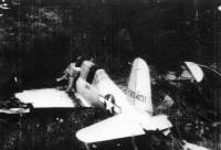
Anyone up for seaching for this?

PostPosted: Thu Sep 27, 2012 8:50 am
by Pitownpi
Image
PM me if you are interested

Peace&Luv,
Pi

http://www.aircraftwrecks.com/pages/bt-13b.htm

PostPosted: Thu Sep 27, 2012 4:11 pm
by KathyW
For those who like finding aircraft crash sites, here are some nice photos take by Joe Idoni:

http://joeidoni.smugmug.com/Aircraft-Crash-Sites

PostPosted: Thu Sep 27, 2012 6:05 pm
by zippetydude
Interesting post Pi!
Interesting reply Kathy!

It brings to mind a silly question.

Seems like most crashes are in the mountains. I would think that pilots would figure, "Just in case of downdraft or the if my bearings are just a little off, I'm going to fly high enough that even if I'm off a little bit I won't slam into a mountain." Pilots are well trained and intelligent, I'm mystified that they hit mountains. I can understand crashing due to engine failure, etc. as there's no avoiding that. But, like the crash on the east face of San G at about 10,000 feet...did they think they were at 12,000 feet or did they think they were flying through the pass? By the way, I intend no disrespect towards any of those who lost their lives, I'm rather a chicken when I fly and I wonder how this happens.

z

PostPosted: Thu Sep 27, 2012 6:58 pm
by Hikin_Jim
Zip,

In the case of the C47 that crashed on San G, they were flying in a snow storm. They didn't have GPS back then, so they wouldn't have known their exact position. They would fly by time, speed, and direction. The problem was that winds could blow them off course, and without visibility, they would have no idea that they were off course.

HJ

PostPosted: Thu Sep 27, 2012 10:28 pm
by lilbitmo
Hikin_Jim wrote:Zip,

In the case of the C47 that crashed on San G, they were flying in a snow storm. They didn't have GPS back then, so they wouldn't have known their exact position. They would fly by time, speed, and direction. The problem was that winds could blow them off course, and without visibility, they would have no idea that they were off course.

HJ


And I think they thought they were in the Cajon Pass, not 5 miles east of it, I think I read that somewhere. But like Zip said, I'd be way above the mountains unless I was out of gas or lost an engine, head to a spot out of the storm if have gas?

PostPosted: Fri Sep 28, 2012 6:09 am
by HH8
lilbitmo wrote:I'd be way above the mountains unless I was out of gas or lost an engine, head to a spot out of the storm if have gas?


For sea-level folk, a sudden (plane speed) ascent to 12,000 ft can be debilitating without special equipment.

PostPosted: Fri Sep 28, 2012 8:03 am
by Pitownpi
It's actually a challenge to take-off in PS and get up and over those peaks!
many older & newer aircraft simply don't have the performance to just 'climb on up' quickly as one might think.
Many of the sites I've visited show they almost cleared the ridge,
petal to the metal/mach-chicken giving it the best shot only to end up splattering in the trees.

Driving in our cars...oopss missed the turn.
in a plane it's oopss, oh s...t, we are gonna hit the mountain,
communication errors, weather, pilot error.:oops: :?

consider 10,000 flights or more went down just training for WWII and then add young pilots, old technology, bad weather, and I'm surprised more planes don't crash.
Planes can't have simple fender benders once airborn.

You really have to give credit to the pilots in general!
I think they do a great job keeping their aircraft in the air!

If ever taking off/landing in Palm Springs in the wind, one might feel the same. pi's a queeze-miester....cars, planes, trains..you name it I've puked on it!:oops:

In the flight videos I've posted, there is always some moments trying to gain altitude.. to clear Zahniser....had to 'switchback' in air several times to build speed and elevation
circling over Big Tree.

The story with this BT-13B is interesting because the pilot hiked out to Palm Springs!!!

It took him 2 days, ,but he survived and was healthy enough to hike!

I really want someone who knows the area to lead on this.
I have GPS and 'know' where it is, but want someone to get me close.
I've never been in that area.

If you want to find it.
PM me.......please!
P,L, &S,
pi
:wink:

PostPosted: Fri Sep 28, 2012 8:04 am
by Hikin_Jim
We forget sometimes what the earlier days of aviation were like. A lot of these planes were unpressurized and did not have temperature controlled cabins. Ever wonder why pilots wore those big heavy "bomber" jackets? Because their planes were freaking freezing inside.

In the case of the C47, the crew compartment was not pressurized IIRC. Fly too high and your passengers are going to be in trouble (the pilots typically had oxygen, but not the passengers). C47's also had only limited climbing capacity, and if they were en route to local base (which I believe they were), then they wouldn't want to be too high.

HJ

PostPosted: Fri Sep 28, 2012 9:13 am
by HikeUp
zippetydude wrote:Seems like most crashes are in the mountains.

I'd postulate that most crash sites in the mountains still have evidence/debris. Crash sites elsewhere have probably been cleaned up.

That actually makes sense. In remote areas things can stay untouched for decades, especially in rugged terrain where access is limited and vegetation slowly hides what's left. Sometimes hikers stumble upon fragments years later just by exploring less-traveled routes.

It’s interesting how people who spend a lot of time outdoors or traveling in remote places end up developing a very independent lifestyle too. I was reading about that mindset recently through Stateless, which gathers a lot of articles about living internationally and outside typical constraints.

Coordinates

PostPosted: Fri Sep 28, 2012 9:43 pm
by halhiker
Is there some list somewhere of coordinates for plane crashes around? I talked to a guy in my old shop one time who had FAA info on crashes and I wrote down a few but that piece of paper is long gone. I'm particularly interested in the Santa Rosas.