This last Monday, 06-18-2012, My friend, Payne, and I, Stockwell, left San Diego to go climb San Gorgonio Mountain via the South Fork and Dry Lake Trails. Having hiked around San Diego for the past 2 years I have wanted to do this peak for a very long time. Payne has just recently began hiking with me and has picked it up with stellar attitude. San Gorgonio was our 10th consecutive hike in 10 consecutive weeks. Last Friday we had hiked up the 3.5 mile trail to the top of San Diego's 2nd tallest peak, Cuyamaca Peak, in 59min. That day was so clear we could see straight out to San Jacinto and San Gorgonio, our goal was in sight!

We left Monday afternoon planning on getting up to the Mill Creek Range Station to get our permits by 8pm. We then went straight up the 38 to Big Bear where we had rented a Motel 6 room for a good nights rest. We woke up at 3:30am Tuesday June 19th 2012 to head to the trail head.
We arrived at the South Fork Trailhead and started our hike by 4:35am, It was still dark. I whipped out my flashlight and we began to march up the trail. Soon enough we had passed Horseshoe meadows and had made it to Manzanita Flats where we enjoyed the cool morning air and a peaking sunrise.

Sugarloaf Peak and a Sunrise from Manzanita Flats
In not too much time after that we had reached Poopout Hill. We took a seat next to the wilderness boundary sign and debated taking the extra 1/4mile to Poopout Hill. I'm sure glad we did as we were blessed with a faint Alpenglow, although it was still the brightest I have ever seen one.


One thing I absolutely loved about this trail was all the sights to see along the way. It seemed like almost every mile was something worthy of a break to look at. Next on our list was the avalanche debris field. I had seen this in so many pictures but it's size really makes you appreciate it so much more in person. I'm skinnier than most of those uprooted trees

We kept moving, the sun was higher in the sky now but blasting on the eastern slopes to our right. As we crossed a small creek we began switchbacking up the trail still in the morning shade all the way to Dry Lake.


We made it to Dry Lake by 8am. Only 3.5 hours and only 2 hours of total moving time. 7 miles in and at 9000' Payne and I were extremely happy. Having been the only people on the trail all morning we had the lake to ourselves, so we stopped and had a bite to eat. We even made some little friends at the lake!


Payne packing up after our break at Dry Lake.

The Trail Past Dry Lake is gorgeous!
Next we came out onto Trail Flats. This was one of my favorite areas, I absolutely loved the sub-alpine views and the close proximity to the mountains. I couldn't help but stare down those chutes on Gorgonio, I can't wait to have a winter attempt here!

Jepson Peak

Our Final Destination : Ol Greyback

Feeling good at Trail Flats
In not too long we made it to Trail Flats Camp. We sadly lost the trail here, (it was to the left of the sign that pointed right to Trail Flats Camp). So we looked around for 10 minuets but ended up just climbing a gully that we could tell led straight to Mineshaft Saddle. Eventually we found trail again and were led straight to the Fish Creek Junction. We stopped here before our push up to the SouthEast Slopes of the mountain.

Trail Flats Camp


This is what we have left to climb
As the trail switchbacked up it also began to narrow. The exposure became astounding and fun! We couldn't wait to get our first real views south towards San Jacinto.


Our First Views South, no San Jacinto yet.

The exposure became increasingly fun!
The sun was getting hotter and we could tell we were climbing higher and getting closer. We slogged up the trail at good pace taking quick stops at every other switchback. At one point Payne yells ahead to me, "Hey shouldn't that plane wreckage be coming up soon." I looked over my shoulder to him and then back up the trail, I saw a bright glint in the now fully risen sun, "Yep, there it is I see the wing!" We stopped at the wreckage briefly checking it out.


We continued along up towards the south side of the mountain. Views of the Tarn and Dragonhead came into view. I was so mesmerized by the views I forgot to take pictures on the way up.

Upper Slopes above The Tarn

Yes! Finally San Jacinto!!! Seems to be a few clicks of Snow left in the Snow Creek Route.

Getting Close

Studs taking a short stop at 11,000!!!
Okay so sadly this is the only picture of Dragonhead that I got. But we believe we found the spot on the trail that makes the mountain look identical to a dragons head laying down into the valley below. Does anyone have a good shot of this?

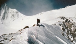
As soon as we had rounded to the southern side of the mountain the winds kicked in. I would guess 20mph with 30mph gusts until we got to the Final Trail Junction. That is also where we ran into our first sighting of other hikers. We quickly passed them and kept moving for the summit.


San Jacinto from the summit of San Gorgonio, I love views like this...
At the top the winds had picked up even more. 50mph gusts by now were becoming more and more frequent. It was awesome
We had made the top by 10:45am. Only a total of 6:15 with a moving time of 3:45. We were so stoked to be up here that early we decided to make our way to the summit shelters and kick back for a bit. We hung out on top for 2 whole hours. We even took a nap! and may I say that the chipmunks on top are just the friendliest little guys.


Our chosen shelter, it was the best one


Me

Payne
We sat up top soaking in the views, hydrating, eating, and resting. Our victory beers were still warm from the hike so we set them on top of the summit shelters and let them chill in the wind. It worked!!!

As you can see we ate like gods!

Soon enough our chipmunk friends joined us. We named this one Marco as he hung out with us for a full hour. They were not afraid.


At about 1pm we decided to start heading down. I personally thought the way down was x4 worse than going up.

Last view of San Jacinto

Last view of San Gorgonios summit

Last view of Mount Baldy

And I just love this view!
We made it back to the car at exactly 5:30pm. Our GPS App that Payne had on his android said that we had hiked 30 miles and 7000 total elevation gain. I don't think soo, I guess our total being at around 26 miles and 5,500 feet total gain. If anyone knows the exact measurements of this trail I'd like to know. We did it in 13 hours and it was a fantastic trip. My favorite hike to date! All I can say is I cannot wait for winter so I can head back up there!!!!!
We sat in the parking lot pouring water all over our feet for a little while. At this point fairly exhausted. We jumped in the car raced down the mountain to the nearest Jack in the Box where we grubbed out! On the way home while driving down the 215 we had our last great view of San Gorgonio...

Me: "Bye Ol Greyback, we'll miss you!"
Payne: "See ya later b****"