Story of missing hiker in Joshua Tree NP

Southern California and far-away places. Hiking, wildlife, cycling etc.

Postby OtherHand » Tue May 08, 2012 5:12 pm

Hikin_Jim wrote:The narrative mentions something interesting.
SATURDAY 6/26/10
At approximately 14:30 hours, Deputy Rinkert informed me that he found several itineraries and maps in the condo that EWASKO was using. (emphasis mine)
Do we know what kind of maps those were? Topo maps? If there were topo maps, maybe Bill had more maps with him than I initially assumed. That could be very important. If he had a quad with Smith Water on it, that would make it more likely that he'd cut XC trying to get to it. Hard to imagine cutting XC to get a canyon that only vaguely know is a couple of miles north of me, although I suppose desperate thirst could have impelled him.

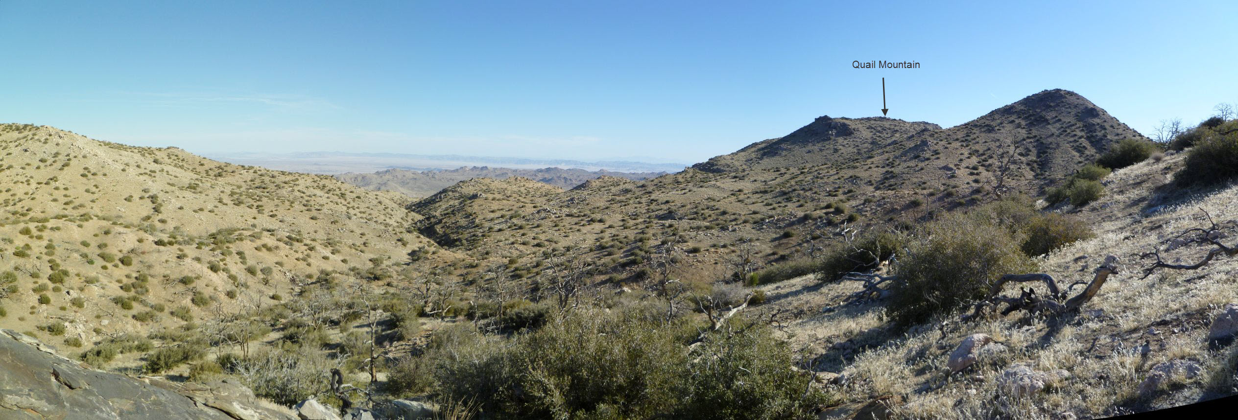
I'm back looking at the topography again. There are a number of (more or less) north-south canyons that intervene between Quail Mountain Ridge and Smith Water Canyon. Those intervening canyons would take you towards Quail Springs/Samuelsons Rock. You'd have to stay fairly far to the west I would think to skirt those drainages and hit the saddle that leads you over the major ridge between Smith Water and Quail. If you stay west, you'd tend to gravitate toward the saddle we've talked about previously which in turn would feed you into the distinctive drainage that goes down to Smith Water, the drainage where the "suspicious" smell was detected.


QUESTION: Based on your first hand observation, which of those saddles is the obvious passage from the SE to get to Smith Water? "M" or "N?"


I don't know exactly what sort of maps Bill had, but I was told by RSO that they found "lots of maps" at his place in Rancho Mirage. That's the extent of my info.

Here's my take on it from the viewpoint of having seen the terrain between Quail and Smith Water: The only reason to go north of the Quail Ridge is if there's a medical issue. You can't get lost and end up heading that way. You can see everywhere. It's like a giant friggin' topo map.

If you decide on a "clever" course of action (clever like the DV Germans!) you head to Smith Water for water. That's a much nastier trip than it visually appears, because you can't see the nightmare descent you have to deal with into the canyon, when you're at your lowest energy.

The other, more conventional exit is to follow the drainages which all lead out to the flat area near Samuelson. You can see the area, and if you have a map, you know the road is there. And it looks close, real close. When I messed up my leg on the north face of Quail, I was sitting there looking at it, thinking how near it seemed, but I knew how hard it would be to get back.

If someone wanted to get to Smith Water from the Quail Mt area, the saddle you've marked N is the obvious choice when viewed from Quail. N appears to be the lowest way across, other than going quite a bit easterly. I'll look around and see if I can find a picture of it. M is pretty much invisible. I think I passed through M on my JT34 trip

I don't know what that email referring to a "blue backpack" means. When I was on the search, we weren't given any info as to clothing or pack, and it's not in any of the FOIA'ed records. I asked Mary if she knew what color Bill's pack was, she said she thought it was black, but wasn't sure. Oh, a couple of other things not in the records.... I asked Mary if Bill used trekking poles and she said no. She also said Bill was of the personality to keep pushing on until he dropped. So factor that into your theorizing.
OtherHand
 
Posts: 290
Joined: Mon Dec 28, 2009 2:07 pm

Postby OtherHand » Tue May 08, 2012 5:19 pm

drndr wrote:i probably didn't read something close but if we're trying to think out of the box , can there be anything more to the rangers and individuals not seeing the car and seemingly pointed in different directions when they do see it? Could it have been moved or strictly human error?

When you come across this sort of thing it's almost always human error. If you've ever had to deal with recollections of people you come across it a lot. Note that Bill's credit cards were never accessed, nor was anything apparently missing from his vehicle. Also two different hikers stated they saw his vehicle during the time period the ranger blew by it. You have to average out the weirdness. Like, for instance, there was no record of his Senior Pass, found in his vehicle, being scanned at any of the entrance stations that day (it's in the narrative). But I seriously doubt it's anything ulterior.
OtherHand
 
Posts: 290
Joined: Mon Dec 28, 2009 2:07 pm

Postby OtherHand » Tue May 08, 2012 5:55 pm

OtherHand wrote: I'll look around and see if I can find a picture of it. M is pretty much invisible. I think I passed through M on my JT34 trip


OK, I've updated myJT34 trip report to include a link to a panorama I took of the area between Quail and Smith Water. If you click on it and spin the little view indicator on the left until you're looking due North, saddle N is in the center of the view.
OtherHand
 
Posts: 290
Joined: Mon Dec 28, 2009 2:07 pm

Postby Hikin_Jim » Wed May 09, 2012 6:19 am

OtherHand wrote:OK, I've updated myJT34 trip report to include a link to a panorama I took of the area between Quail and Smith Water. If you click on it and spin the little view indicator on the left until you're looking due North, saddle N is in the center of the view.
When I go to JT34, I see a wide angle photo that wasn't there before, but I don't see the 360 pano.

HJ
Backpacking stove reviews and information:  Adventures In Stoving
Personal hiking blog: Hikin' Jim's Blog
User avatar
Hikin_Jim
 
Posts: 4938
Joined: Mon Oct 30, 2006 9:12 pm
Location: Orange County, CA

Postby Hikin_Jim » Wed May 09, 2012 8:00 am

OtherHand wrote:I don't know exactly what sort of maps Bill had, but I was told by RSO that they found "lots of maps" at his place in Rancho Mirage. That's the extent of my info.
Any chance of getting a dump of what maps and/or guide books there might have been? Might tell us something.

With what we do have, we can tell we have a man who likes maps and is clearly not shy about spending money to get maps for a place he's interested in. So, if he's a map afficianado, perhaps he had the necessary topo to get to Smith Water. If he's got a topo, how might that change his route selection?

OtherHand wrote:Here's my take on it from the viewpoint of having seen the terrain between Quail and Smith Water: The only reason to go north of the Quail Ridge is if there's a medical issue.
Agreed.

OtherHand wrote:If you decide on a "clever" course of action (clever like the DV Germans!) you head to Smith Water for water. That's a much nastier trip than it visually appears, because you can't see the nightmare descent you have to deal with into the canyon, when you're at your lowest energy.
This is the internet age. There are references to Smith Water aplenty, many with photos of running water.

Image

Just a few minutes Google searching led me to dozens of references to Smith Water including some that describe it as one of the highlights of Joshua Tree NP. I think Bill had more than enough knowledge to try a DV German "clever" course of action.

OtherHand wrote:The other, more conventional exit is to follow the drainages which all lead out to the flat area near Samuelson. You can see the area, and if you have a map, you know the road is there. And it looks close, real close. When I messed up my leg on the north face of Quail, I was sitting there looking at it, thinking how near it seemed, but I knew how hard it would be to get back.

Yeah, but if he was just looking for an exit, why not go back the way he came? Smith Water makes a lot more sense when you consider a man who's been out in the heat for multiple days. He's desperately thirsty.

HJ
Last edited by Hikin_Jim on Wed May 09, 2012 3:11 pm, edited 3 times in total.
Backpacking stove reviews and information:  Adventures In Stoving
Personal hiking blog: Hikin' Jim's Blog
User avatar
Hikin_Jim
 
Posts: 4938
Joined: Mon Oct 30, 2006 9:12 pm
Location: Orange County, CA

Postby drndr » Wed May 09, 2012 2:28 pm

ok, i'm still thinking way out of the box. Who is Ken and Helen? Someone 3000 miles away knows he was going to call them, even has their number, then ken says he never heard of Ewasko. This, mixed in with questions if cars were moved, seems interesting. I know Jtree is huge but odd none of his stuff has ever been seen of. Just completely vanished after 2 years. An experienced hiker, careful enough to call people and leave itineraries, seemingly map knowledgeable, just seems he could have gotten out of there or had left lots of evidence as to where he may be.

Oh, and I'm not a mystery nut or conspiracy theorist
:D
"Everywhere is walking distance if you have the time"
drndr
 
Posts: 233
Joined: Mon Oct 15, 2007 11:10 am
Location: Riverside

Postby Hikin_Jim » Wed May 09, 2012 2:53 pm

drndr wrote:Who is Ken and Helen? Someone 3000 miles away knows he was going to call them, even has their number, then ken says he never heard of Ewasko.
Yeah, that's a fair question. It could be that a friend of Bill's just said "Oh, you're going hiking in Joshua Tree? You should call my friends Ken and Helen. They hike there all the time and can tell you all about it." I guess we really don't know.

Then there's that 10.6 mile-from-the-tower cell phone ping. To me that says that he's out there and that this SAR incident should be taken at face value. I could be wrong about that though.

HJ
Backpacking stove reviews and information:  Adventures In Stoving
Personal hiking blog: Hikin' Jim's Blog
User avatar
Hikin_Jim
 
Posts: 4938
Joined: Mon Oct 30, 2006 9:12 pm
Location: Orange County, CA

Postby Hikin_Jim » Wed May 09, 2012 3:13 pm

If he's got a topo, how might that change his route selection?
Well, if he's got a topo, the ridge on this map marked by points "F", "G", "H", and "I" stands out. Everything else has some pretty closely crowded topo lines (i.e. steep). Particularly if he's injured he may have thought long and hard about an easy way down to Smith Water Canyon. Note on the map that I've drawn a route from the SE to Smith Water. The saddle just SW of pt. 5652 (point "C") makes more sense to use if you've got a topo and want to use the ridge as your route of travel. Just a thought.

Interesting as well is that Smith Water Canyon is roughly 10.6 miles from the cell phone tower. There is a patch of cell phone coverage from the tower at point "C".

HJ
Backpacking stove reviews and information:  Adventures In Stoving
Personal hiking blog: Hikin' Jim's Blog
User avatar
Hikin_Jim
 
Posts: 4938
Joined: Mon Oct 30, 2006 9:12 pm
Location: Orange County, CA

Postby drndr » Wed May 09, 2012 3:25 pm

Damn you and your good answers!

If I was him, here's what i'd done.

I decide to do Jtree in June. It's hot but I'm going anyways becuase I just came from Georgia. I get there and it is hot so I skip Quail Peak altogether because I don't want the hard up hill. I'm thinking I heard of this place called Smith canyon. Pics show trees and water. Rather flat to get there and an established trail. Perfect.

I get to the canyon and something tragic happens. Snakebite or Hard getting down some of those rocks with water and i break my leg bad, or something. I know I'm in trouble because i haven't had cell phone service at all on my hike. So I wait it out, theres water and a bit of protection from the elements. Someone will come. 2 days and no one. I gotta get out where there may be phone service. Straight up out of the canyon. I'm thinking the northeast side because cell strength might be stronger there closer to Yucca Valley. On my way up the wall on the 27th just as I get my "ping" off I have my 2nd tragedy and die. From what I can tell the northeast side of Smithwater has been the least searched according to the maps

I don't try to go back the way I came because it is far and I know there has been no cell phone service.
"Everywhere is walking distance if you have the time"
drndr
 
Posts: 233
Joined: Mon Oct 15, 2007 11:10 am
Location: Riverside

The ping

Postby halhiker » Wed May 09, 2012 3:40 pm

The cell phone ping seems to be the big issue that everyone's concentrating on but I have to wonder how reliable that is. I live less than two miles from a cellphone tower and yet I sometimes don't get calls and voicemails appear hours—or longer—later. I wonder if the info could have finally been cobbled together enough to represent a ping but could have been from days earlier and perhaps from further away than the suggested 10 odd miles. I am not a phone tech but I know radio waves can be screwy. I mean, I get AM radio waves from Utah sometimes at night.

I guess my question is: Is that ping absolutely reliable or could it have been delayed until the server processed the info?
User avatar
halhiker
 
Posts: 1260
Joined: Mon Oct 16, 2006 12:00 pm
Location: La Quinta, CA

PreviousNext

Return to Outdoors-Related Topics

Who is online

Users browsing this forum: No registered users and 49 guests