Below are some photos of my hike from Sunday, April 10. In total I covered 16 miles RT with a 4300 foot elevation gain. Here are the photos:
https://picasaweb.google.com/1175322595 ... Apr102011#
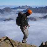
I've wanted to summit the west Ridge of Palomar Mountain for years. By checking out Google earth I determined that it was the only location on the entire mountain where you could observe unrestricted views to the south towards San Diego County, and to the north towards Riverside County from one location. I knew that Dripping Springs trail on the north side of the mountain could access this ridge, but the route was really long, and I didn't see much information on where how & where it joined with Palomar Ridge Truck Trail. I had read about the "Palomar Epic Loop" on Mt. Bike Bill's website years ago, and saw that there was a direct route up the south side of the mountain. On further research I determined that it was called "Gomez Trail. See Bill's report here:
http://www.mountainbikebill.com/PalomarEpicLoop.htm
I knew the weather would be getting hot soon and wanted to check out the last snow of the season on the mountain. I hit the trail at 6:30Am and summited by 10:00AM. The views were as spectacular as I imagined both to the north and to the south. My camera does not do it justice.
On a side note, this trail traverses Pauma Indian land so next time I would need to get permission before hiking it. Another option would be to go in through Palomar State Park, up Doane Valley Road then over through Palomar Divide Road.
All in all it was a good primer for San Jacinto in May.

Mt. San Jacinto Outdoor Recreation
Hiking, Climbing, Camping, Trail Running, Snowshoeing...
Palomar- Agua Tibia Hike: 4/10/2011
6 posts
• Page 1 of 1
Palomar- Agua Tibia Hike: 4/10/2011
![]() by Lermo » Mon Apr 11, 2011 4:03 pm
by Lermo » Mon Apr 11, 2011 4:03 pm
-
Lermo - Posts: 128
- Joined: Thu Mar 03, 2011 7:43 pm
- Location: Fallbrook, CA
![]() by lilbitmo » Mon Apr 11, 2011 4:43 pm
by lilbitmo » Mon Apr 11, 2011 4:43 pm
Nice TR and route, looks like you scoped it out carefully before heading out - the flowers in the spring after a good wet winter are always a nice pleasant array of beauty. Thanks for posting this Lermo, I've always wanted to get up to the top of that side of Palomar, I'll have to push it up my list 
-

lilbitmo - Posts: 550
- Joined: Sun Feb 03, 2008 11:37 pm
![]() by Sally » Mon Apr 11, 2011 7:37 pm
by Sally » Mon Apr 11, 2011 7:37 pm
Hi Lermo, thanks for a great TR. The Agua Tibia Wilderness is practically in my neighborhood (I can get to the Dripping Springs trailhead in less than 15 minutes). I have always wanted to go to the top of the ridge and then jus keep going until I reach Palomar.
The bush with the bluish flowers is lilac.
The bush with the bluish flowers is lilac.
-

Sally - Posts: 1125
- Joined: Thu Sep 17, 2009 8:27 pm
- Location: Temecula
Palomar- Agua Tibia Hike: 4/10/2011
![]() by Lermo » Tue Apr 12, 2011 8:09 am
by Lermo » Tue Apr 12, 2011 8:09 am
Hi Lilbitmo- That part of the mountain sees little or no hiking or Mt. Bike traffic. Since I was going alone, I wanted to make sure what I was getting myself into. I'll have to get one of those Spot locators so my wife can rest assured a little when I take off on these solo adventures.
Hey Sally- Thanks for the heads up on that blooming Lilac! I've always wondered what those bushes were called when they all cover the hillsides during the springtime. Yea, I'm only 15 minutes from this trail myself. With the respectable elevation gain, it's a good training hike (or mt. bike) close to home.
I will be contacting the tribal office for a definitive answer on traversing their land. I believe there is only a couple mile section that is actually on their land so maybe they will be accommodating
-
Lermo - Posts: 128
- Joined: Thu Mar 03, 2011 7:43 pm
- Location: Fallbrook, CA
![]() by Andy » Wed Apr 13, 2011 1:26 pm
by Andy » Wed Apr 13, 2011 1:26 pm
Lermo,
I've spent a good amount of time in the area around west Palomar and Agua Tibia over the years. The last time I was on the divide was about two years ago when I hiked from Doanes Pond to Eagle Craig. It did include a fair amount of trespassing though, as the old Palomar truck trail now crosses several tracts of Private and/or Indian land. I didn't encounter any people other than a logging crew near the cell tower farm (that I snuck around) but there was plenty of tire tracks along the route showing heavy traffic. I also saw some of the biggest Mt lion prints I've ever seen and quite a few sizable deer. All of that said, I can't recommend this route, even though it is a wonderful 17 mile round trip.
On the Gomez route from Adams Dr in Pauma Valley. Years ago I rode my Mt Bike up this route and ran into an Indian Ranger about half way up. He politely informed me that I was trespassing and that no permission was ever granted to non-official (logging / Telecom / USFS) persons due to insurance reasons. Being that I'd already been up there numerous times over the years, I happily turned around and rode back down the road.
So...as far I know there is no legal access to that western ridge line except from Agua Tibia / Wildhorse or Cucta Valley / Highpoint Rd. Once you head east from Eagle Craig you're an outlaw
I'd be happy to share any other area info with you...just let me know.
- Andy
- Posts: 350
- Joined: Mon Feb 04, 2008 4:21 pm
- Location: Temecula
![]() by Lermo » Wed Apr 13, 2011 2:11 pm
by Lermo » Wed Apr 13, 2011 2:11 pm
Thanks for the feedback Andy. I entered via Adams Dr. too. I kind of figured that the access might be an issue because there wasn't any information out there on this side of the mountain except for as you mentioned, Dripping Springs trail to Eagle Crag, but nothing further east. It's a real shame because this is a beautiful area. I'll probably ping you next time I head out that way for more legal alternatives like dripping springs to Eagle Crag.
-
Lermo - Posts: 128
- Joined: Thu Mar 03, 2011 7:43 pm
- Location: Fallbrook, CA
6 posts
• Page 1 of 1
Return to Outdoors-Related Topics
Who is online
Users browsing this forum: No registered users and 2 guests