Page 1 of 2

Mt.San Gorgonio (via South Fork Trail - Dry Lake)

PostPosted: Wed Oct 13, 2010 1:40 pm
by hydromeo
Hi,

I am planning to backpack and hike the South Fork Trail on 10/23-10/24(overnighting at Dry Lake). I would like to know the status of running water along the trail. The information on sgwa.org website seems outdated and I couldn't reach Mentone ranger station for this information. Any information or additional tips is appreciated.

Thanks in advance.

-Raj

PostPosted: Wed Oct 13, 2010 9:15 pm
by SoCalJim
Lodgepole Spring is reliable and flowing well according to recent posts. I overnighted at Lodgepole last week. In the smaller section of Lodgepole Camp where I stayed (the draw just north of the main section where Lodgepole Spring is located and the trail from Fish Creek runs), there's also a small spring on the left when you walk four minutes back in there. It was flowing at over a gallon a minute.

PostPosted: Wed Oct 13, 2010 11:11 pm
by Hikin_Jim
Raj,

There's always good water where the trail forks. Fork to the right goes to Dollar Lake and the fork to the left goes to Dry Lake. If you take the fork to the left (to Dry Lake), you'll have to cross not one but two creeks. I can't imagine either of these two creeks going dry, ever. This is a good spot to get some water.

There are also several places where water runs over the trail as you hike to Dry Lake from S. Fork meadows, at least one of which has enough flow where you could collect some water.

There's some water still in Dry Lake although it's mostly a marsh right now.

Lodgepole Spring is flowing very well.

HJ

PostPosted: Wed Oct 13, 2010 11:12 pm
by Hikin_Jim
SoCalJim wrote:Lodgepole Spring is reliable and flowing well according to recent posts. I overnighted at Lodgepole last week. In the smaller section of Lodgepole Camp where I stayed (the draw just north of the main section where Lodgepole Spring is located and the trail from Fish Creek runs), there's also a small spring on the left when you walk four minutes back in there. It was flowing at over a gallon a minute.
Hey, Jim,

Is that spring you're talking about in this draw?

HJ

PostPosted: Thu Oct 14, 2010 7:40 am
by hydromeo
Thanks for the information. I'll file for permit right away.

-Raj

PostPosted: Thu Oct 14, 2010 11:05 pm
by SoCalJim
HJ, actually, it's just north of and parallel to the drainage where Lodgepole Spring is located, if I have my bearings correct. I've never actually eyeballed Lodgepole Spring, but my understanding is it's located on the south side of that drainage. The spring I'm referring to is on the north side of the draw and there were no other springs or water flows in the vicinity. Also, no obvious trail leading further east past the spring.

PostPosted: Fri Oct 15, 2010 7:50 am
by Hikin_Jim
Hmm. Do you mean that he spring you're talking about is above what's considered Dry Lake Camp? In other words somewhere in the draw marked by "B"?

HJ

PostPosted: Fri Oct 15, 2010 10:29 pm
by SoCalJim
HJ, yeah, that looks right to me. Like I said, from the edge of Dry Lake, walk in there past camp sites for about four minutes, dodging fallen trees. Spring's flowing from the wall of the draw on the left as you walk east. Grass is fairly trampled around the spring, so others clearly know where it is. According to the funky wooden sign at the edge of Dry Lake that shows the camping areas, that is the left or more northerly arm of Trail Fork Camp. The main one, as I interpret the sign, is just to the right and is in the mouth of the larger part of Trail Fork Camp where the trail to Fish Creek Saddle runs. Or maybe the place I'm describing is Dry Lake Camp and it just isn't clear to me.

PostPosted: Sat Oct 16, 2010 4:28 pm
by Hikin_Jim
SoCalJim wrote:HJ, yeah, that looks right to me. Like I said, from the edge of Dry Lake, walk in there past camp sites for about four minutes, dodging fallen trees. Spring's flowing from the wall of the draw on the left as you walk east. Grass is fairly trampled around the spring, so others clearly know where it is. According to the funky wooden sign at the edge of Dry Lake that shows the camping areas, that is the left or more northerly arm of Trail Fork Camp. The main one, as I interpret the sign, is just to the right and is in the mouth of the larger part of Trail Fork Camp where the trail to Fish Creek Saddle runs. Or maybe the place I'm describing is Dry Lake Camp and it just isn't clear to me.
Hi, Jim,

I think I've got it now. The camps (plural) that you're describing are not Trail Fork Camp. Trail Fork Springs Camp is on the Forsee Creek Trail. The camps that you're describing are Dry Lake Camp (the northernmost) and Lodgepole Camp (the southernmost). They're considered separate camps even though they're so close together.

If you take a look at this map of the area, point "A" marks Trail Fork Springs Camp, point "B" marks Dry Lake Camp, and point "C" marks Lodgepole Camp.

The first signs that you come to are pretty specific that there are two camps.
Image

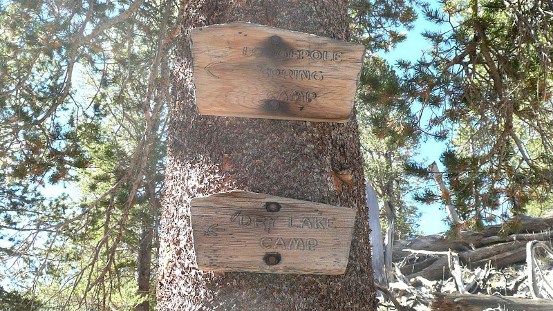
The now second sign (it's been recently moved) says "Dry Lake/Lodgepole Camp," the slash implies that there are two camps, but not really saying which is which. Dry Lake Camp is the smaller camping area, and Lodgepole Camp is the larger. The trail to Fish Creek Saddle runs through the Lodgepole Camp area as you mentioned.
Image

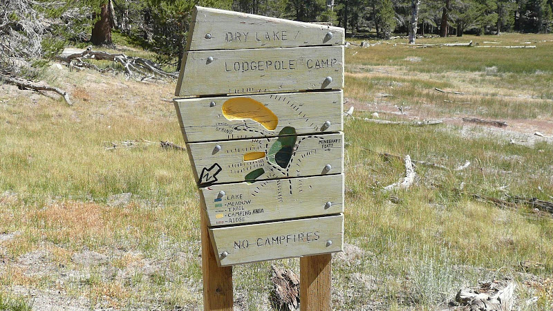
I notice on the map that the Dry Lake Camp area splits into two ravines. Is the spring in the main ravine or the smaller ravine that points almost north?

HJ

PostPosted: Sat Oct 16, 2010 4:40 pm
by SoCalJim
I think I got distracted looking at another thread in naming Trail Fork. I DID mean Lodgepole. And the spring I'm talking about is right where you marked with a "B".