that was tough
http://socalhikes.com/2009/08/galena-little-san-gorgonio-traverse/

Mt. San Jacinto Outdoor Recreation
Hiking, Climbing, Camping, Trail Running, Snowshoeing...
Galena - Little San Gorgonio Traverse
11 posts
• Page 1 of 2 • 1, 2
Galena - Little San Gorgonio Traverse
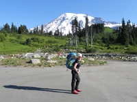
![]() by Zé » Sun Aug 30, 2009 8:59 pm
by Zé » Sun Aug 30, 2009 8:59 pm
- Zé
- Posts: 552
- Joined: Mon Jun 09, 2008 8:41 pm
![]() by tinaballina » Mon Aug 31, 2009 11:31 am
by tinaballina » Mon Aug 31, 2009 11:31 am
Nice TR, glad you and winston made it safe and sound.
So, if no yuciapa ridge on the 19th does that mean iron baldy traverse?
So, if no yuciapa ridge on the 19th does that mean iron baldy traverse?
-
tinaballina - Posts: 1107
- Joined: Tue Jan 08, 2008 11:21 am
- Location: Riverside
![]() by zippetydude » Mon Aug 31, 2009 1:08 pm
by zippetydude » Mon Aug 31, 2009 1:08 pm
Great job. Cool pics. I thought you'd be up there pretty soon.
How was the path coming down? Was it pure xc or is there a use trail of some sort?
z
How was the path coming down? Was it pure xc or is there a use trail of some sort?
z
-

zippetydude - Posts: 2751
- Joined: Tue May 09, 2006 5:40 am
![]() by Hikin_Jim » Mon Aug 31, 2009 2:34 pm
by Hikin_Jim » Mon Aug 31, 2009 2:34 pm
Hey, Zip, so I guess you're all right?
Those fire maps in the media are never accurate, but this one does show you as being pretty close. No evac's for you?
My mom was evac'd on Saturday and still can't go back. The flames got within a few hundred yards of her house. Most intense thing I've ever seen. House still standing as of this morning. They're lighting a back fire (a "controlled" burn in the vicinity of a fire to eliminate fuel before the fire gets there) near Deukmejian Wilderness Park which is near her. I sure hope the back fire doesn't backfire, if you'll pardon the pun.
Michiko and I are not under mandatory evac (yet). The mandatory evac line is one block north of us, about a 5 minute walk up Commerce Street. If you look at a map of the Tujunga Evac Zone, the SW corner of the of the evac zone is on the corner of Commerce and Apperson. If you go south on Commerce one block, you'll see Little Landers Park which is on the corner of Valmont and Commerce. We live right near that intersection.
No immediate danger for us right now, but this is a little too close for comfort.
Hope you guys are OK out there.
I think AlanK should be OK. He's on the opposite side of the Crescenta/Cañada Valley.
Anyone else we know affected by this big mess?
HJ
P.S. Dang good job, Zé. Sorry to hijack the thread but I had been thinking about Zip and the fires which are big on my mind because of my situation.
Last edited by Hikin_Jim on Mon Aug 31, 2009 4:11 pm, edited 1 time in total.
Backpacking stove reviews and information: Adventures In Stoving
Personal hiking blog: Hikin' Jim's Blog
Personal hiking blog: Hikin' Jim's Blog
-

Hikin_Jim - Posts: 4958
- Joined: Mon Oct 30, 2006 9:12 pm
- Location: Orange County, CA
![]() by AlanK » Mon Aug 31, 2009 2:54 pm
by AlanK » Mon Aug 31, 2009 2:54 pm
Hikin_Jim wrote:I think AlanK should be OK. He's on the opposite side of the Crescenta/Cañada Valley.
We are on the opposite side of the valley and have been watching the smoke during the day and the flames at night. We have had quite a few friends and acquaintances evacuated. Meanwhile, I am pretty down about all the damage to our beautiful forest.
We had some La Canada friends staying with us for three nights. They headed to San Diego yesterday to stay with one of their kids. The fire made it to the top of their short street on Friday, but their place is ok.
We had what I hope is our only direct experience with fire in early August. Some contractors doing some work on our house had a fire that scared the heck out of us but ended up doing relatively minor damage to one room. Of course "relatively" is important here. Repairs cost money and time and insurance companies threaten not to renew people who actually make claims. It's all very educational.
-

AlanK - Posts: 855
- Joined: Tue May 09, 2006 7:31 am
- Location: Glendale, CA
![]() by zippetydude » Mon Aug 31, 2009 3:53 pm
by zippetydude » Mon Aug 31, 2009 3:53 pm
Alan, sorry to hear about your fire. "Educational" is a very optimistic term!
Jim, no we're not facing evacuation, and I hope you're not either. Here's a better map:
http://rimoftheworld.net/4033
We're in the neighborhood at the bottom left. The fire has not been moving towards us - almost entirely east (to the right in the map) so we're very close but seemingly quite safe. If there's a change in the wind, that could place us in the path of the fire, but if things hold as they are, we're fine.
z
-
zippetydude - Posts: 2751
- Joined: Tue May 09, 2006 5:40 am
![]() by bluerail » Mon Aug 31, 2009 4:06 pm
by bluerail » Mon Aug 31, 2009 4:06 pm
My prayers and thoughts are with you all that might be affected by the fire. Hope the winds don't shift and all is well at your house Zip.
Sounds like a good trip Ze.
Sounds like a good trip Ze.
Last edited by bluerail on Mon Aug 31, 2009 4:09 pm, edited 1 time in total.
-

bluerail - Posts: 2108
- Joined: Thu Dec 11, 2008 10:30 am
- Location: La Quinta
![]() by Hikin_Jim » Mon Aug 31, 2009 4:08 pm
by Hikin_Jim » Mon Aug 31, 2009 4:08 pm
Ah, OK, that's a much better map. The LA Times map shows it practically in you backyard.zippetydude wrote:Alan, sorry to hear about your fire. "Educational" is a very optimistic term!
Jim, no we're not facing evacuation, and I hope you're not either. Here's a better map:
http://rimoftheworld.net/4033
We're in the neighborhood at the bottom left. The fire has not been moving towards us - almost entirely east (to the right in the map) so we're very close but seemingly quite safe. If there's a change in the wind, that could place us in the path of the fire, but if things hold as they are, we're fine.
z
I noticed the Tujunga evac zone near me and Michiko has been moved further east on the Times map; they probably just got a more exact deliniation of the fire from the authorities. That's at least some relief now that it's about four blocks away instead of one.
Glad to hear you're OK. Say hello to Ivette and the girls for me. Please tell Ivette that Michiko is coming along fine. She's due in less than three weeks.
Backpacking stove reviews and information: Adventures In Stoving
Personal hiking blog: Hikin' Jim's Blog
Personal hiking blog: Hikin' Jim's Blog
-
Hikin_Jim - Posts: 4958
- Joined: Mon Oct 30, 2006 9:12 pm
- Location: Orange County, CA
![]() by Zé » Tue Sep 01, 2009 11:11 am
by Zé » Tue Sep 01, 2009 11:11 am
tinaballina wrote:Nice TR, glad you and winston made it safe and sound.
So, if no yuciapa ridge on the 19th does that mean iron baldy traverse?
oh trust me there is plenty of yucaipa ridge left. this was just the part most people don't go. to try to do the entire thing with a big group as a dayhike would be a looooong day.
I got an idea for something brutal for that day.
zippetydude wrote:Great job. Cool pics. I thought you'd be up there pretty soon.
How was the path coming down? Was it pure xc or is there a use trail of some sort?
z
at some points there was a use trail coming down, but I wouldn't trust my tracks as I went even more cross-country, making my own path for most of it. going up would probably be easier, but still without any nagivation tools it would be tough to follow
- Zé
- Posts: 552
- Joined: Mon Jun 09, 2008 8:41 pm
11 posts
• Page 1 of 2 • 1, 2
Return to Outdoors-Related Topics
Who is online
Users browsing this forum: No registered users and 4 guests