This thread has so many posts I hadn't seen the map links. Wow. That's a ton of exploring. I had no idea. Great job, I hope it leads to a discovery!
z

Mt. San Jacinto Outdoor Recreation
Hiking, Climbing, Camping, Trail Running, Snowshoeing...
Story of missing hiker in Joshua Tree NP

![]() by Myth » Sun Feb 03, 2013 8:19 pm
by Myth » Sun Feb 03, 2013 8:19 pm
Wow, I just made the world's ugliest screen shot. I am so proud.
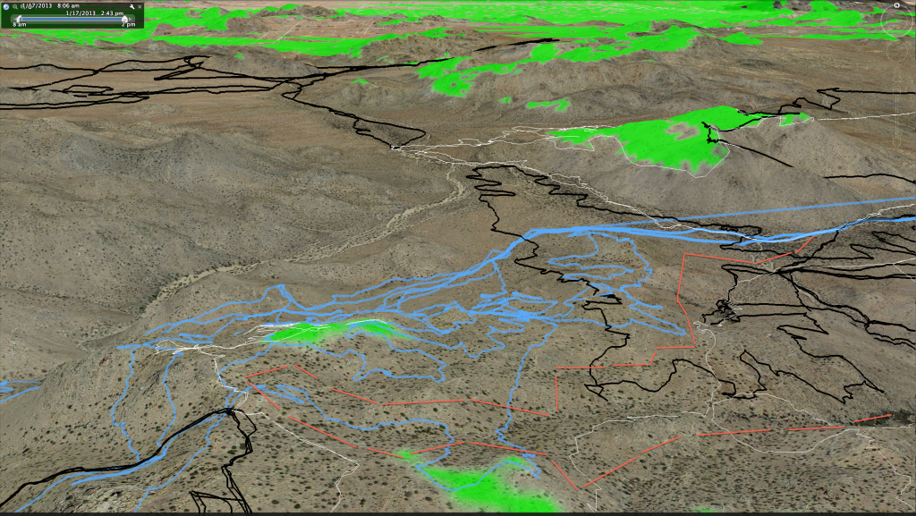
I just switched to a new computer since my old one crapped out and now nothing is where I like it, so bear with me. But here's a tentative idea of the kind of thing I have in mind. I've pretty much decided to go in from the NE and try and fill in some gaps in the area. I will probably also range much further west towards the odor location, following another "fill in" type contour along the rim of Smith Water.
This screen grab gives a rough idea of my thoughts. This might be the way we approach. There's nothing pretty or pleasant about it - will be a lot of on-a-slope walking. That's what adjustable hiking poles, mid-length boots and a careful step are for.
This screen grab is from Google Earth. I laid in one of OtherHand's cell coverage views, the one that is "clearest", to give an idea of where we're looking. Smith Water runs down the screen from left middle towards the top center. Quail Wash comes down where the black tracks are. The baby blue is the search tracks from JT45. The little red squiggle is the kind of thing we might do. You'll notice how we're going up, and then down. I may save investigating that green gully where we suspect water might be for the return trip instead - in fact, I probably will. I just want to give a rough idea of what's floating around in my head right now. I'm considering a dip or two towards Smith Water, but - having been out in Joshua Tree recently, I have looked hard at the terrain. If you're injured to the point where you cannot easily walk, distance is hard to come by. An experiment if you wonder how hard: sit down on your lawn. Scoot along backwards on your butt, dragging a leg. See how tiring it is. I tried it. I've forgotten how tough it is to drag yourself over the ground. Walking with my bruised leg, I was reminded of how mentally taxing it is to force yourself into pain with every step. Imagine having real, debilitating pain from a joint injury. So I wonder if you're going to want to give up altitude when you've made it all the way to this spot. Bill sent out a cell ping. He was hoping to call in help. He may have been hoping to be seen from the air. Maybe he was up in this cell coverage area on Sunday. Would he have lost altitude in a last ditch effort? Would he have stayed in the area? I don't know, obviously. I hope by filling in a few gaps and by descending toward that vegetation spot, I might answer some of these questions for us by a process of elimination.
I'll take the GPS tracks with me and try to cover mostly new ground. I have to balance searching on this trip with make sure my spouse will ever go on another trip with me but I am hopeful of adding to the body of knowledge we have. I have a very patient, detail-oriented personality. I can spend days covering every inch of ground in a detailed search pattern for you. My spouse, on the other hand, has an "entertain me now" personality. We'll see how this pans out.
Hikin_Jim - your idea of a steep north face is a great thought! A north face would make cell coverage for that ping that much more likely. I am going to spend some time looking for north-facing boulders on Google satellite view, and also keep it in mind during my search.
Thank you, also, for the recommendation on some binoculars. I will try to head down to a store and see if I can find something. I kind of live in a backwater, so it is hard to find good stuff in regular stores, but we'll see.
Any thoughts, advice, etc, still appreciated.
I just switched to a new computer since my old one crapped out and now nothing is where I like it, so bear with me. But here's a tentative idea of the kind of thing I have in mind. I've pretty much decided to go in from the NE and try and fill in some gaps in the area. I will probably also range much further west towards the odor location, following another "fill in" type contour along the rim of Smith Water.
This screen grab gives a rough idea of my thoughts. This might be the way we approach. There's nothing pretty or pleasant about it - will be a lot of on-a-slope walking. That's what adjustable hiking poles, mid-length boots and a careful step are for.
This screen grab is from Google Earth. I laid in one of OtherHand's cell coverage views, the one that is "clearest", to give an idea of where we're looking. Smith Water runs down the screen from left middle towards the top center. Quail Wash comes down where the black tracks are. The baby blue is the search tracks from JT45. The little red squiggle is the kind of thing we might do. You'll notice how we're going up, and then down. I may save investigating that green gully where we suspect water might be for the return trip instead - in fact, I probably will. I just want to give a rough idea of what's floating around in my head right now. I'm considering a dip or two towards Smith Water, but - having been out in Joshua Tree recently, I have looked hard at the terrain. If you're injured to the point where you cannot easily walk, distance is hard to come by. An experiment if you wonder how hard: sit down on your lawn. Scoot along backwards on your butt, dragging a leg. See how tiring it is. I tried it. I've forgotten how tough it is to drag yourself over the ground. Walking with my bruised leg, I was reminded of how mentally taxing it is to force yourself into pain with every step. Imagine having real, debilitating pain from a joint injury. So I wonder if you're going to want to give up altitude when you've made it all the way to this spot. Bill sent out a cell ping. He was hoping to call in help. He may have been hoping to be seen from the air. Maybe he was up in this cell coverage area on Sunday. Would he have lost altitude in a last ditch effort? Would he have stayed in the area? I don't know, obviously. I hope by filling in a few gaps and by descending toward that vegetation spot, I might answer some of these questions for us by a process of elimination.
I'll take the GPS tracks with me and try to cover mostly new ground. I have to balance searching on this trip with make sure my spouse will ever go on another trip with me
Hikin_Jim - your idea of a steep north face is a great thought! A north face would make cell coverage for that ping that much more likely. I am going to spend some time looking for north-facing boulders on Google satellite view, and also keep it in mind during my search.
Thank you, also, for the recommendation on some binoculars. I will try to head down to a store and see if I can find something. I kind of live in a backwater, so it is hard to find good stuff in regular stores, but we'll see.
Any thoughts, advice, etc, still appreciated.
- Myth
- Posts: 149
- Joined: Thu Dec 27, 2012 12:05 pm
![]() by OtherHand » Sun Feb 03, 2013 9:20 pm
by OtherHand » Sun Feb 03, 2013 9:20 pm
That's actually a pretty good plan, one I'd consider doing as a solo trip. Wait...Uh, I guess that's not a ringing endorsement. But it is a good, "fill in the gaps" route. The terrain you're routing through isn't really bad, once you get above Quail Spring. The first part of that climb can be steep.
You might want to check out Quail Springs as there are some old foundations there. If you do,read this before you go. It's some writing by Earle Stanley Garner (The Perry Mason guy) who used to camp there and wrote about Samuelson. This piece was from when he was camping there in 1928. Quite different there then.
I won't try and discourage you from checking out the vegetated area. That black line on the north side and the white line on the southerly side was me, looking down into it thinking, "Nope, don't' wanna to go down there". I thought I got a clear view of the bottom. Your mileage may vary. If you're planning on just taking that canyon back down I should warn you there's a reason I stayed out of it on the descent. There is a lot of rock and brush in the bottom which would make for very slow going. And the large canyon it dumps into (which flows past Quail Springs) is also a pain. Hence my path tends to stay on the open ridgeline to the north. Would Bill have done it? I don't know, but I'm pretty lazy and on the return for these trips I tend to take the easiest, obvious route.
You might want to have some sort of plan in the back of your mind to appease the wife after this.....She will likely hate you.
BTW, I will PM you with an information item regarding your route.
- OtherHand
- Posts: 291
- Joined: Mon Dec 28, 2009 2:07 pm
![]() by OtherHand » Sun Feb 03, 2013 9:40 pm
by OtherHand » Sun Feb 03, 2013 9:40 pm
One more thing on your path. I see you just did a bunch of line segments in Google Earth. What I usually use is the "Add Path" command. It lets you draw whatever route you want. Each time you click the mouse it adds a new segment to the path.
You can also edit the path after you've drawn it by right clicking on it and bringing up "Properties". You can then grab and move any of the path's nodes. Again under "Properties" you can see the elevation profile of the path and it's length. Very handy, if sometimes depressing.
When you get a route you're happy with you can select the path and do a "Save Place As" to someplace on your computer as a .kml file (not kmz). The final step is to useGPsBabel (freeware) to convert your kml file to a gpx or gdb file to import to your GPS. Thus you can easily follow your preplanned route in the field.
- OtherHand
- Posts: 291
- Joined: Mon Dec 28, 2009 2:07 pm
![]() by Myth » Mon Feb 04, 2013 9:19 am
by Myth » Mon Feb 04, 2013 9:19 am
OtherHand - there you go again, encouraging me about my plans!
That's only a small bit of a possible route, of course. I have to sit down and work out a good one that will range over 8-10 miles for the first day and 6-8 for the next day - neither day too long in order to leave time for detailed exploring in any interesting areas. And all of it likely to be scuttled whole or in part once I see the terrain.
I am going up there to try to fill in some gaps in the searching and add my own small set of tracks and impression of the area to the huge amount of searching already done. I will also see about trying to camp in the general vicinity of an area of interest, perhaps, and spending an hour or so poking around in a smallish area in detail, sans pack, at the end of the day. In order to make the trip home the next day manageable, such a spot would probably be anywhere from 6-8 miles away from the trail head, so we can be back at the vehicle with daylight left to drive in, and still have time to dally a bit on the way out if we see any interesting spots to look at. I tend to get up pretty early on hiking days, a sleeping pad is not comfortable enough to linger on ...
I'll check out that vegetated area and I may well come away with the same impression you did, especially if those bushes are the hungry kind. If I don't have binoculars with me, I might drop down to take a look. If it looks too hairy, it would be doubtful Bill would have went in, because it would have been too hard for him to get out.
As far as my screen grab goes, that was just messing around in a silly drawing program. I tried doing the line segments in Google Earth, but my stupid Mac would *not* let me draw a path. The Mac probably involves some sort of weird click to get started on a path, so I just said "Aww, I'll deal with it tomorrow" and opened a screenshot in Preview to doodle on. I'll need to sit down tonight or tomorrow night at the latest and get it figured out so I can set up my path and maybe a few waypoints for possible areas of interest.
Thank you for explaining how to get that information into my GPS! That saves me the "fun" of figuring it out myself - I have only done it the other way around.
- Myth
- Posts: 149
- Joined: Thu Dec 27, 2012 12:05 pm
![]() by drndr » Mon Feb 04, 2013 10:17 am
by drndr » Mon Feb 04, 2013 10:17 am
Earle Stanley Garner story is great. Been out to Samuelsons a few times and now know the rest of the story. Do you know if there is still a functioning Quail Spring water pump hut out there? I have seen an old abandoned platform and photos of a supposed existing one.
"Everywhere is walking distance if you have the time"
- drndr
- Posts: 236
- Joined: Mon Oct 15, 2007 11:10 am
- Location: Riverside
![]() by neverwashasbeen » Mon Feb 04, 2013 10:39 am
by neverwashasbeen » Mon Feb 04, 2013 10:39 am
The water pump was still working on my last visit, but that was about a year ago.
Happy Trails!
-
neverwashasbeen - Posts: 437
- Joined: Tue May 19, 2009 6:34 am
- Location: Palm Springs
![]() by OtherHand » Mon Feb 04, 2013 11:23 am
by OtherHand » Mon Feb 04, 2013 11:23 am
neverwashasbeen wrote:The water pump was still working on my last visit, but that was about a year ago.
Are you confusing Quail Springs with the mouth of Johnny Lang Canyon? There isn't a pump at Quail, although there is an old stone tank and some other stone works.
- OtherHand
- Posts: 291
- Joined: Mon Dec 28, 2009 2:07 pm
![]() by Perry » Mon Feb 04, 2013 11:56 am
by Perry » Mon Feb 04, 2013 11:56 am
I realized another factor is that probably only those directly involved with the search were included in the time cards, so there's still the possibility for human error of not including Ranger Grayson. Only a FOIA request to NPS headquarters to get his time card would determine whether he exists.
"And he knows those computers better than anybody, all those computers, those vote-counting computers. And we ended up winning Pennsylvania like in a landslide, so, it was pretty good, it was pretty good, so thank you to Elon!"
-Donald Trump
-Donald Trump
-

Perry - Site Admin
- Posts: 1525
- Joined: Mon May 08, 2006 6:01 pm
- Location: Palm Springs, CA
![]() by neverwashasbeen » Mon Feb 04, 2013 4:58 pm
by neverwashasbeen » Mon Feb 04, 2013 4:58 pm
I'm certainly not as familiar with the area as Otherhand, but when drndr mentioned Samuelson's Rocks, I suspected he meant the pump south of that location.
Happy Trails!
-
neverwashasbeen - Posts: 437
- Joined: Tue May 19, 2009 6:34 am
- Location: Palm Springs
Return to Outdoors-Related Topics
Who is online
Users browsing this forum: No registered users and 3 guests