Story of missing hiker in Joshua Tree NP

Southern California and far-away places. Hiking, wildlife, cycling etc.

Postby Hikin_Jim » Tue Jan 15, 2013 9:15 pm

OtherHand wrote:OK, you fans of the "Smith Water scenario" might find the following new additions to my stuff on Bill of interest.
Interesting indeed.

So, you did go and glass the SE side of Smith Water from the NW side? You guys must really be grasping for straws if you're doing things I've thought of. :wink: From my May 7th post:
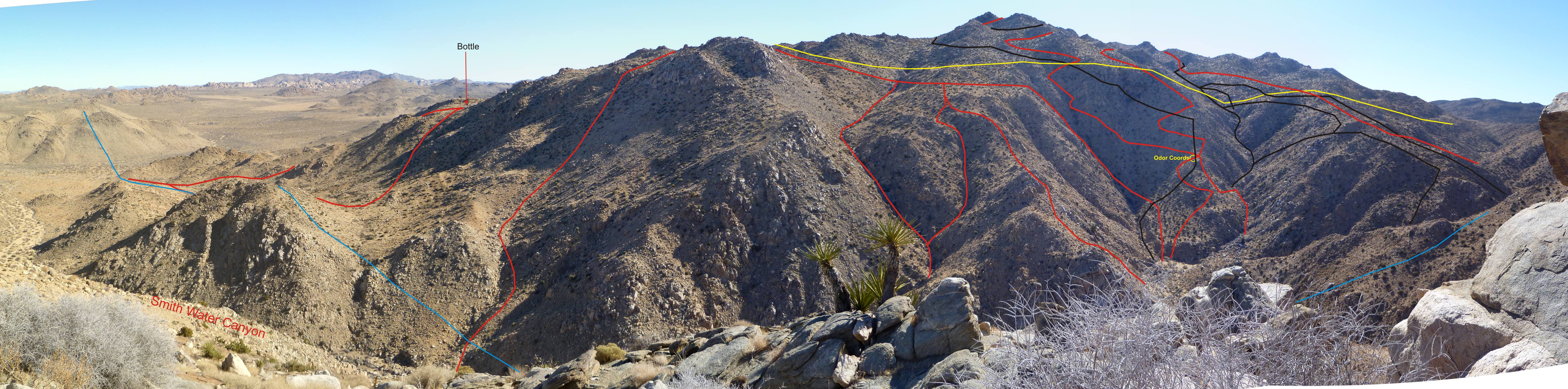
Hikin_Jim wrote:I wonder if a trip to the opposite (northerly) side of Smith Water would be in order? Tough probably to see down in to the bottom of the canyon, but a guy with a good pair of binocs might be able to scan the walls of the canyon where Bill might have tried to descend and gotten cliffed out or something. Just a thought.


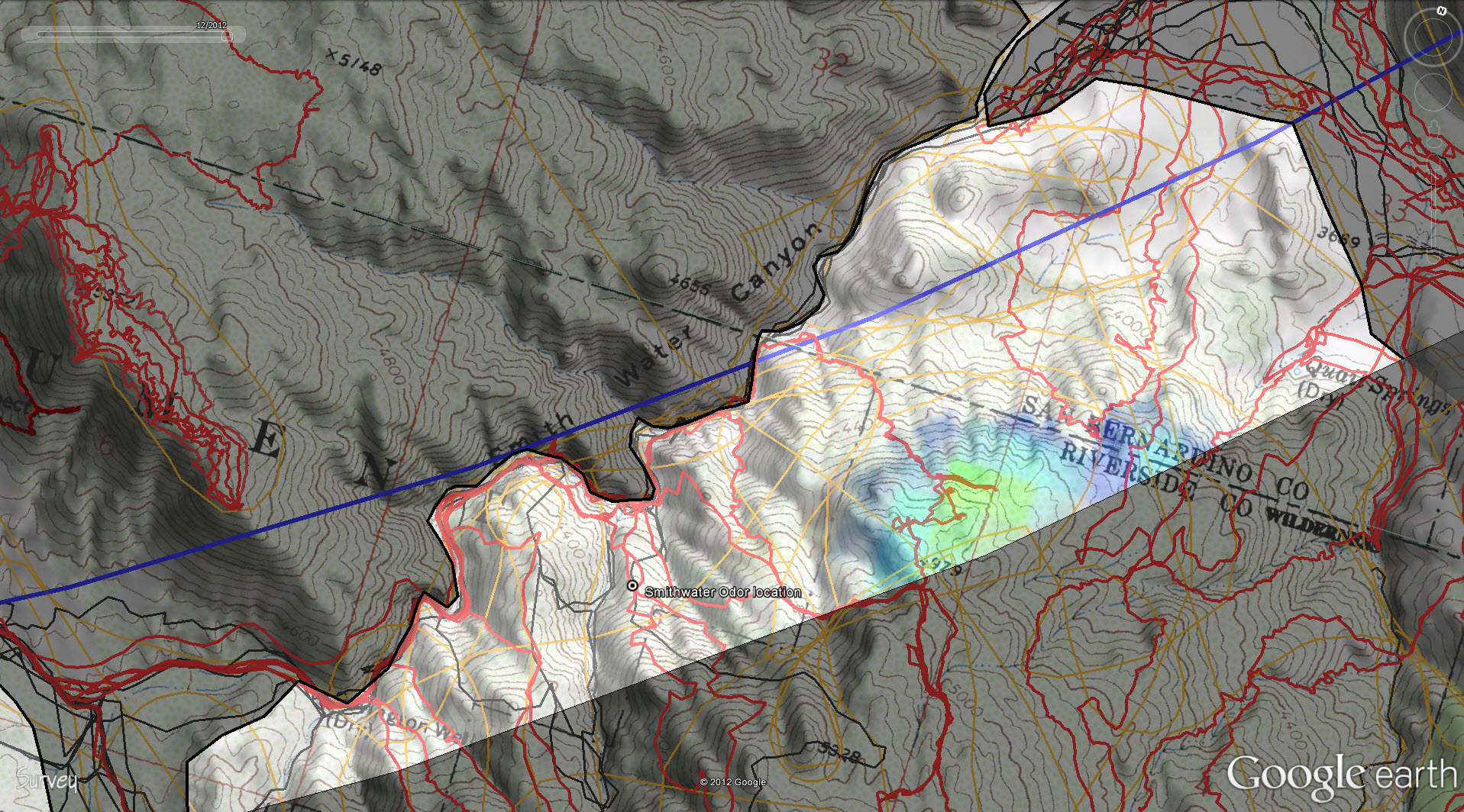
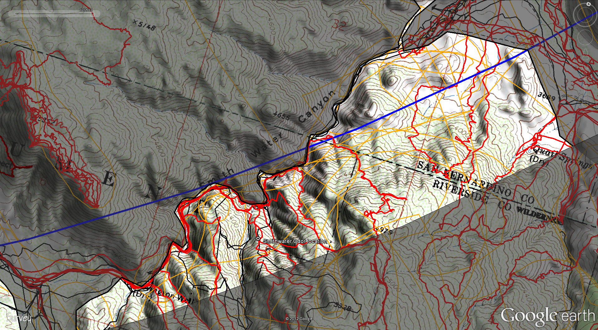
OtherHand wrote:I think Bill is going to be eventually found on the southerly slopes of Smith Water Canyon, or just above them, towards the easterly portion of the canyon. It will be in rocky terrain probably with visibility towards the sky limited.
Image

Wow, that far east? I had not considered that he might be that far east.

So, he heads for Smith Water, decides to bail out in the direction of Quail Springs Road (i.e. North), gets injured/can't continue, and tries for Smith Water again, but this time further north and east. A bit of a stretch, but it fits with the cell ping, and Bill clearly did something unusual, something that made sense at the time to a man with a good general knowledge of Joshua Tree -- but perhaps not specific knowledge of the descent routes into Smth Water. In other words, Bill knew just enough to get him into serious trouble. With more complete knowledge, I doubt anyone in his shoes would try to enter Smith Water via that area.

HJ
Backpacking stove reviews and information:  Adventures In Stoving
Personal hiking blog: Hikin' Jim's Blog
User avatar
Hikin_Jim
 
Posts: 4958
Joined: Mon Oct 30, 2006 9:12 pm
Location: Orange County, CA

Postby OtherHand » Tue Jan 15, 2013 10:05 pm

Hikin_Jim wrote:Wow, that far east? I had not considered that he might be that far east.


We hadn't either, which is why we had only done a few trips in there. But with the new cell data it makes sense. It had to be an area as close as possible to the 10.6 mile line, which is the east end of the canyon, not the west. There needs to be actual cell coverage close and there should be at least a semi-plausible reason for Bill to be there. No other area fits that hasn't already been searched or can be otherwise excluded.
OtherHand
 
Posts: 291
Joined: Mon Dec 28, 2009 2:07 pm

Postby Hikin_Jim » Tue Jan 15, 2013 11:07 pm

Yeah, it does seem like a pretty good fit, particularly with the now greatly heightened confidence in the cell phone ping.

Pretty tough area to search though, based on what I've seen and the topo lines.

Speaking of the terrain, we've previously discussed the "obvious" saddle at point "A." Points "B" through "E" describe what I thought was the best route into Smith Water from the Quail Mountain area, but Bill's not there, and our focus has moved to the northeast of that ridge (marked by "B" through "E"). If Bill is further to the NE, where does the terrain tend to channel him? Perhaps something along the lines of "I" through "M". Note that the line of travel described by "I" through "M" avoids some of the steeper terrain that drops off to the even further NE. The commanding terrain feature is still that ridge that separates Smith Water from the terrain to the NE, the ridge described by points "A" and "M." Is there another "obvious" passage over that ridge for someone headed to Smith Water? Perhaps nothing as obvious as the saddle at "A," but there is a saddle at "M." Interestingly, there is a small, easily climbed knob (judging by the topo) just north of "M," point 4979, that would have a fairly good view of the area. Were I trying to get a cell phone call out, I might climb that knob. I might also try to climb that knob just to get a look at the surroundings and get my bearings. Incidentally, the cell phone coverage here looks pretty strong.
Image

I don't know what Bill could see from the vicinity of point "M"/point 4979, but I do notice that there is a patch of verdant green (point "G") that the terrain west of "M" would funnel someone towards. I'm speculating of course, but the gully that generally leads from "M" to Smith Water might be worth looking at.

If Bill had a detailed map and were in the vicinity of "M," he might notice that things get rather steep as one approaches the bottom of Smith Water. I think the fairly obvious gully leading to Smith Water is the more likely choice, but if Bill had a map, he might have picked out a better route, perhaps something like this somewhat doglegged route. Again, though, I think just heading down the gully that proceeds to Smith Water from "M" is more likely, particularly if he caught a glimpse of that greenery that I pointed out earlier (point "G" in the first map link).

HJ
Backpacking stove reviews and information:  Adventures In Stoving
Personal hiking blog: Hikin' Jim's Blog
User avatar
Hikin_Jim
 
Posts: 4958
Joined: Mon Oct 30, 2006 9:12 pm
Location: Orange County, CA

Postby Hikin_Jim » Wed Jan 16, 2013 9:45 pm

Another thought on the above:

Am I reading this map properly? It appears that no one has searched down the gully that leads from the saddle just south of point 4979 to Smith Water. The very lowest section has a red track which I presume means it's been covered, but much of that gully from the saddle down has not been covered. Have I got that right?

HJ
Backpacking stove reviews and information:  Adventures In Stoving
Personal hiking blog: Hikin' Jim's Blog
User avatar
Hikin_Jim
 
Posts: 4958
Joined: Mon Oct 30, 2006 9:12 pm
Location: Orange County, CA

Postby OtherHand » Wed Jan 16, 2013 11:38 pm

Hikin_Jim wrote:Another thought on the above:

Am I reading this map properly? It appears that no one has searched down the gully that leads from the saddle just south of point 4979 to Smith Water. The very lowest section has a red track which I presume means it's been covered, but much of that gully from the saddle down has not been covered. Have I got that right?

HJ


You are reading it right, but it's not correct. There were four of us on that outing and we sent Pete down that ravine as it looked bad and he deserved it (he described it as "fun"). He also wasn't carrying a GPS at the time. We now know better and collar him with a spare one like a mountain lion. The panorama of the southerly slopes taken on JT44 does show a red track down that ravine as I drew them in by hand.

A more interesting omission is the ravine just above the word "Odor". I missed that one completely. That's my track passing by it just above its start and then to the west, at which point I descended down to the bottom and recall I kissed the ground when I made it down. That missed ravine is still a possibility and we spent some time looking at it from the north side of the canyon on JT44. Unfortunately we only had a side view from our vantage point and couldn't quite see its bottom. That's not especially a spot I'd want to hike in and try and climb up (or down!). It looks like a very hairy chute to check out but remains a possibility.
OtherHand
 
Posts: 291
Joined: Mon Dec 28, 2009 2:07 pm

Postby Hikin_Jim » Thu Jan 17, 2013 12:16 am

Ah. I should have just gone straight to your photo with the hand drawn routes. It really gives a better sense of the terrain as well as what has been covered and what has not.

Looking at the photo, my "dog legged" route might actually make some sense, particularly if Bill had a map -- which my gut feeling is that he did. I see a search track going down the gully I picked out as a possible route, the gully marked by points "E" and "F". However, there's another gully over there that might be worth checking out, the gully that more or less goes straight from "C" to "F." I'm sure you'll check everything over there out, but that one gully strikes me as having potential.

The gully below the odor could also be interesting to check out, although that's not very far to the east and doesn't seem to have good coverage from the Serin Drive cell tower.

Another idea that might put Bill to the east is that he may have been aware of the dry falls in Smith Water. If his plan, based on a late start was to go to Quail, get water in Smith Water, and the exit to Quail Springs Road and walk the road after dark (I've planned several outings that way -- get to something relatively easily to negotiate in the dark before sun down), he might have deliberately gone to the NE from the Quail Mtn area, making sure he'd miss the falls AND placing him relatively closer to the exit of the canyon so that he'd be able to get to the road sooner. Who knows? In any event, the cell ping and his conspicuous absence elsewhere make the NE slopes of Smith Water we've been discussing seem like a logical place to look.

HJ
Backpacking stove reviews and information:  Adventures In Stoving
Personal hiking blog: Hikin' Jim's Blog
User avatar
Hikin_Jim
 
Posts: 4958
Joined: Mon Oct 30, 2006 9:12 pm
Location: Orange County, CA

Postby drndr » Thu Jan 17, 2013 11:26 am

Paranoid conspiracy theory first.

Still find it odd that a trained park ranger looking for a white car and a missing person drives right by Juniper Flats parking lot 4 times (coming and going to Keys view) and doesn't see the car. We know it was there Thur night and Fri morn. Then gone fri afternoon and Sat morn. Then seen again 1pm Sat. and confirmed at 5. And that parking lot is in plain view right along the road. All odd.

His fiance has a correct number and names of "Ken and Helen". Ken is called by Rangers and Sheriffs but he claims to have never heard of Bill. I would be curious if Bill's phone records were checked. Did he only make that one call thurs morning and then nothing else til that solitary ping on Sunday morning. Was that number ever called even back home in Geogia?

How well did he really know JTree? There were directions in the car how to get to the Juniper Flats Trailhead from West Entrance. Had he done much hiking out there?

These seem to be the only real facts we have. And that ping from what I think to understand could be anywhere in that 10 mile radius, even the opposite direction out past Landers.

Lost hiker theory second.

He's gone Thurs, Fri, and Sat and is some kind of condition that he can't get anywhere to get a ping out. Then all of a sudden Sunday morning, at assuming his weakest condition, he can get somewhere and get a ping out. I can't even picture this scenario. Maybe thursday he goes straight to SWC, hurts himself, sits there for 3 days, realizes no ones coming for him and climbs out. The whole area has been covered and pretty well by helicopters too. I don't get it. And if sunday he is strong enough to get somewhere new to get a ping out, why not keep going. I still like the idea of of the North Western hills out of SWC. Less searching done there and less helicopters too.

Otherhands new area to search is at least easy to get to but like it's been said before, Bill is probably no where near where people have been looking.

Just my thoughts
"Everywhere is walking distance if you have the time"
drndr
 
Posts: 236
Joined: Mon Oct 15, 2007 11:10 am
Location: Riverside

Postby OtherHand » Thu Jan 17, 2013 8:50 pm

There were four of us out there today with no luck. Pretty hellacious terrain and I'd guess a probability of detection level of no more than 50%. Way more chutes and ravines that either the topo maps or aerials suggest. Not that we didn't find stuff as each of us found our very own Big Horn sheep skeleton, which is the most we've ever seen out there. Weird, must be where they go to die.

Hikin_Jim wrote:
Looking at the photo, my "dog legged" route might actually make some sense, particularly if Bill had a map -- which my gut feeling is that he did. I see a search track going down the gully I picked out as a possible route, the gully marked by points "E" and "F". However, there's another gully over there that might be worth checking out, the gully that more or less goes straight from "C" to "F." I'm sure you'll check everything over there out, but that one gully strikes me as having potential.
HJ


I know more than I care to about your dog legged route. But if you're going from A to C, why bother with B? Why not go straight to C? You get to experience the fantastic cliffs just east of C! Another one of those "kiss the ground when finally reaching the bottom" moments.

More on all this after I crunch the data, look at our GPS tracks and see where the hell we actually were. I hurt.....
OtherHand
 
Posts: 291
Joined: Mon Dec 28, 2009 2:07 pm

Postby Hikin_Jim » Thu Jan 17, 2013 11:15 pm

OtherHand wrote:I know more than I care to about your dog legged route. But if you're going from A to C, why bother with B? Why not go straight to C? You get to experience the fantastic cliffs just east of C! Another one of those "kiss the ground when finally reaching the bottom" moments.
Ah. This must be one of those routes Pete describes as "fun." :shock:

OtherHand wrote: I hurt.....
Take care of yourself.

OK, so (when you've recovered a bit) reason with me here for a minute. We know Bill's vehicle location. That's a solid data point. We've got a ping from the Serin Drive cell tower on Sunday at about 10.6 mi. That's a solid data point. We know there's fairly good cell coverage from the Serin tower in and around Pt. 4979. That's a pretty solid data point too. For a guy coming from the Juniper Flats Trailhead, the NE slopes of Smith Water toward Quail Springs is the only place that makes sense for him to ping that tower.

I can't help but think that this graphic (click to enlarge) might be the key to the whole thing:
Image
On Sunday, Bill was in the area shown with cell coverage in and around Pt. 4979 within the 11.1 mile radius.

The question then becomes where did he go from there? Did Bill try to make it down to Smith Water even though he was injured? Did Bill divert more to the east towards Quail Springs looking for an easier way down? I'm not Bill, but if it were me and I were injured, I'd balk at the sight of the descent into Smith Water. I'd turn to the NE and try to descend, something the along lines of the two routes shown on this map. Shoot, by the time Sunday rolled around, he may have been in such bad shape that he, unable to get down to Smith Water, crawled into this vegetation to take shelter -- and never came out again. Unfortuntely, I can't do more than speculate as to what exactly happened, but it really does fit that Bill is in the NE Smith Water region somewhere.

Good luck.

HJ
Backpacking stove reviews and information:  Adventures In Stoving
Personal hiking blog: Hikin' Jim's Blog
User avatar
Hikin_Jim
 
Posts: 4958
Joined: Mon Oct 30, 2006 9:12 pm
Location: Orange County, CA

Postby Perry » Fri Jan 18, 2013 2:51 am

OtherHand wrote:And Bill will likely be found in a place where no one's been (Cabo San Lucas has been suggested to me).

What about Cancun?
http://www.theprofitdrivers.com/about-ams/bill-ewasko/
http://www.theprofitdrivers.com/
Bottom of main page:
"Want 2010 to be more profitable than 2009?"
"And he knows those computers better than anybody, all those computers, those vote-counting computers. And we ended up winning Pennsylvania like in a landslide, so, it was pretty good, it was pretty good, so thank you to Elon!"
-Donald Trump
User avatar
Perry
Site Admin
 
Posts: 1525
Joined: Mon May 08, 2006 6:01 pm
Location: Palm Springs, CA

PreviousNext

Return to Outdoors-Related Topics

Who is online

Users browsing this forum: No registered users and 7 guests