
Five Fingers 12/19/2014

Southern California and far-away places. Hiking, wildlife, cycling etc.

Five Fingers 12/19/2014

Postby tekewin » Tue Dec 30, 2014 4:30 pm

I was intrigued by Five Fingers (5174') coming back from Mt. Whitney in 2013. It is clearly visible from highway 395 as the southern Sierra melts into the high desert. It turns out to be a popular HPS destination, but I was alone on the mountain when I went. The standard route from the south starts at a turnout on Indian Wells Canyon Road. It is a dirt road that a low clearance vehicle can navigate with some caution. From the turnout, I headed for the saddle between finger #4 and #5 on the far left. About half way up, I ran into a use trail that was not obvious at the start. The slope was very steep sand and gravel, and gained about 1500' in 0.8 miles. My hiking pole was sinking 6-12" deep every time I put it down. It was slow going up to the saddle.

Image
Five Fingers from the turnout, the high point is on the summit of finger #5 on left

Image
Looking back, about half way up, the turnout is visible and the black dot is my 4Runner

Once at the saddle, I proceeded to the north side and down to the spiny ridge, then back up. I soon reached two class 3 chutes and chose the one on the left. It was a fun climb to the top, where I turned right and scrambled about 100' to the summit. There I found an ammo box with a couple of registers. The newest one was placed in 2013 and had hundreds of names. Coming down, I was able to plunge step as if in deep snow, making it down from the saddle in about 1/3 of the time it took to go up. The hike was short, sweet, and big fun.

Image
Two class 3 chutes up, I took the blue route

Image
Almost to the top of the chute

Image
The other fingers from finger #5

Image
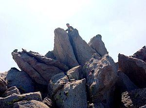
Summit block

Image
On the summit

Image
Registers

Image
Last look back

Image
Part of the California Aqueduct system taking water from central CA to LA
User avatar
tekewin
 
Posts: 95
Joined: Mon Apr 01, 2013 5:19 pm
Location: United States

Re: Five Fingers 12/19/2014

Postby Myth » Wed Dec 31, 2014 11:31 am

Neat! I haven't been up the Five Fingers yet, but I did do some walking in Indian Wells Canyon not too long ago. The first part of the dirt road is indeed fine. It does get more gnarly up higher in the canyon, to the point where high clearance was pretty much needed. ( No 4x needed, not that my truck even has it! )

At some point I took a wrong turn onto a now disused BLM road, couldn't get up a slope, and hung my tiny little truck up on a big rock right under the armpit while backing down. Gravity helped scrape me off that rock and I ended up defeated at the bottom of the slope with a worrisome burning smell in the air ( turned out it was some vegetation I backed over, nothing serious ). Not my finest moment. I beat a careful, many-pointed turn-retreat and hiked up the rest of the way ( my destination was at the top of the canyon ).

I did eye the Five Fingers on the way down. The view from the top of the canyon was great, I'm sure it would be even better from up there. The whole area is beautiful to me. I'll try it out when I get the chance, though 1,500 feet in 0.8 miles, up a sandy hillside sounds like ... um, fun! The kind of slope you basially climb twice going up ;) I had a little taste of it churning up the hillside higher in the canyon.

Myth
 
Posts: 149
Joined: Thu Dec 27, 2012 12:05 pm

Re: Five Fingers 12/19/2014

Postby zippetydude » Thu Jan 01, 2015 11:31 am

Great TR. I never would have expected that sand/gravel slope to be that deep and loose. Reminds me of Cinder Cone on Mt. Lassen. Hard on the way up but fun on the way down. Looks like a fun side trip on the way up the 395! I just might give it a try next time I head up that direction. How long did the whole adventure take you? Thanks for the post!

z
User avatar
zippetydude
 
Posts: 2751
Joined: Tue May 09, 2006 5:40 am

Re: Five Fingers 12/19/2014

Postby zippetydude » Thu Jan 01, 2015 11:51 am

Great TR. I never would have expected that sand/gravel slope to be that deep and loose. Reminds me of Cinder Cone on Mt. Lassen. Hard on the way up but fun on the way down! Looks like a fun side trip on the way up the 395 - I just might give it a try next time I head up that direction. How long did the whole adventure take you? Thanks for the post!

z
User avatar
zippetydude
 
Posts: 2751
Joined: Tue May 09, 2006 5:40 am

Re: Five Fingers 12/19/2014

Postby tekewin » Thu Jan 01, 2015 12:09 pm

Zippetydude,

The round trip was just under 2.5 hours, including a short diversion around the north side of finger #4. With 4WD, there are dirt roads that can get you much closer on the north side if you prefer to spend more time scrambling on the rocks.
User avatar
tekewin
 
Posts: 95
Joined: Mon Apr 01, 2013 5:19 pm
Location: United States


Return to Outdoors-Related Topics

Who is online

Users browsing this forum: No registered users and 6 guests