
Mt. San Jacinto Outdoor Recreation
Hiking, Climbing, Camping, Trail Running, Snowshoeing...
Skyline on Saturday, June 4
12 posts
• Page 1 of 2 • 1, 2
Skyline on Saturday, June 4
![]() by Wildhorse » Thu Jun 02, 2016 6:05 am
by Wildhorse » Thu Jun 02, 2016 6:05 am
Anyone planning to do Skyline this Saturday?
- Wildhorse
- Posts: 548
- Joined: Tue Oct 19, 2010 1:11 pm
Re: Skyline on Saturday, June 4
![]() by mattytreks » Thu Jun 02, 2016 6:47 am
by mattytreks » Thu Jun 02, 2016 6:47 am
I'll either be at SanG or Baldy this weekend, but the weather forecast is calling for some pretty high temps!
Whoever is doing Skyline, be safe and start early.
Whoever is doing Skyline, be safe and start early.
-
mattytreks - Posts: 104
- Joined: Sun Apr 01, 2007 12:25 pm
- Location: San Diego, CA
Re: Skyline on Saturday, June 4
![]() by Hikin_Jim » Thu Jun 02, 2016 10:28 am
by Hikin_Jim » Thu Jun 02, 2016 10:28 am
Hey 2600, what watch is that? I lost my Suunto and need a new one. I'm wanting an altimeter function but not GPS.
HJ
HJ
Backpacking stove reviews and information: Adventures In Stoving
Personal hiking blog: Hikin' Jim's Blog
Personal hiking blog: Hikin' Jim's Blog
-

Hikin_Jim - Posts: 4958
- Joined: Mon Oct 30, 2006 9:12 pm
- Location: Orange County, CA
Re: Skyline on Saturday, June 4
![]() by Hikin_Jim » Thu Jun 02, 2016 11:30 am
by Hikin_Jim » Thu Jun 02, 2016 11:30 am
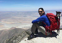
Yeah, that's my experience too with my old Suunto Vector. I had to reset it every few hours whenever I'd hit a known point in order to keep it accurate. Air pressure does vary throughout the day, so I think this is normal.2600fromatari wrote:It is the Suunto Core. This exact one:
http://www.amazon.com/Suunto-Core-Altim ... ge_o07_s00
http://www.suunto.com/en-US/Sports-Watc ... ollection/
The altimeter was okay, but not as precise as I'd hope for it to be. When that picture was taken, I know I was about 300 ft higher than the state elevation. Sometimes the elevation is within 10 ft and at other times it was several hundred feet off. Not a complete deal breaker, but I wish it was more precise.
Thanks for confirming which watch that is. The Core is the one I've been looking at. I would prefer all black, but it's $70 more for some reason.
HJ
Backpacking stove reviews and information: Adventures In Stoving
Personal hiking blog: Hikin' Jim's Blog
Personal hiking blog: Hikin' Jim's Blog
-
Hikin_Jim - Posts: 4958
- Joined: Mon Oct 30, 2006 9:12 pm
- Location: Orange County, CA
Re: Skyline on Saturday, June 4
![]() by zippetydude » Thu Jun 02, 2016 2:51 pm
by zippetydude » Thu Jun 02, 2016 2:51 pm
Forecast: Low of 81, high of 114. Um, Cynthia, what is your opinion on this matter?
z
z
-

zippetydude - Posts: 2751
- Joined: Tue May 09, 2006 5:40 am
Re: Skyline on Saturday, June 4
![]() by Hikin_Jim » Thu Jun 02, 2016 3:24 pm
by Hikin_Jim » Thu Jun 02, 2016 3:24 pm
114? No problem. I was tired of life anyway. 
HJ
HJ
Backpacking stove reviews and information: Adventures In Stoving
Personal hiking blog: Hikin' Jim's Blog
Personal hiking blog: Hikin' Jim's Blog
-
Hikin_Jim - Posts: 4958
- Joined: Mon Oct 30, 2006 9:12 pm
- Location: Orange County, CA
Re: Skyline on Saturday, June 4
![]() by Ed » Thu Jun 02, 2016 4:40 pm
by Ed » Thu Jun 02, 2016 4:40 pm
I think it is time for Cynthia's seasonal message.
- Ed
- Posts: 843
- Joined: Wed Oct 27, 2010 2:04 pm
- Location: San Diego Area
Re: Skyline on Saturday, June 4
![]() by cynthia23 » Thu Jun 02, 2016 8:44 pm
by cynthia23 » Thu Jun 02, 2016 8:44 pm
Sorry dudes, I have been amiss on my 'rant' duty. Wildhorse, I have to believe you're messing with me a little bit. 
Or, perhaps trying to get a conversation going on the subject? I'm fairly sure you aren't seriously going to go up Skyline this Saturday!! I sure hope not cause we need your lively commentary on this board, and if you aren't alive anymore, that's the end of that!
Ok. gonna post my rant now.
Or, perhaps trying to get a conversation going on the subject? I'm fairly sure you aren't seriously going to go up Skyline this Saturday!! I sure hope not cause we need your lively commentary on this board, and if you aren't alive anymore, that's the end of that!
Ok. gonna post my rant now.
Q: How many therapists does it take to screw in a light bulb? A: Only one, but the light bulb has to want to change ...
- cynthia23
- Posts: 1289
- Joined: Tue Nov 07, 2006 3:33 pm
- Location: Rancho Mirage
Re: Skyline on Saturday, June 4
![]() by cynthia23 » Thu Jun 02, 2016 8:44 pm
by cynthia23 » Thu Jun 02, 2016 8:44 pm
Sorry dudes, I have been amiss on my 'rant' duty. Wildhorse, I have to believe you're messing with me a little bit.
Or, perhaps trying to get a conversation going on the subject? I'm fairly sure you aren't seriously going to go up Skyline this Saturday!! I sure hope not cause we need your lively commentary on this board, and if you aren't alive anymore, that's the end of that!
Ok. gonna post my rant now.
Or, perhaps trying to get a conversation going on the subject? I'm fairly sure you aren't seriously going to go up Skyline this Saturday!! I sure hope not cause we need your lively commentary on this board, and if you aren't alive anymore, that's the end of that!
Ok. gonna post my rant now.
Q: How many therapists does it take to screw in a light bulb? A: Only one, but the light bulb has to want to change ...
- cynthia23
- Posts: 1289
- Joined: Tue Nov 07, 2006 3:33 pm
- Location: Rancho Mirage
Re: Skyline on Saturday, June 4
![]() by Wildhorse » Thu Jun 02, 2016 9:29 pm
by Wildhorse » Thu Jun 02, 2016 9:29 pm
Would love to climb Skyline this Saturday, but at last minute change in plans has me in Pacific Grove Saturday where it will be about 50 degrees cooler. Burrrr.
Skyline could be crowded. The folks who hike on such days are a marvel to me. The summer Skyline risk is too high for me. I would surely wilt in such heat. I have taken other risks that have made a big positive difference to my life.
Cynthia's warnings are worth heeding by almost everyone.
I posted this question just to see what we might find out.
- Wildhorse
- Posts: 548
- Joined: Tue Oct 19, 2010 1:11 pm
12 posts
• Page 1 of 2 • 1, 2
Return to Mt. San Jacinto & Santa Rosa Mountains
Who is online
Users browsing this forum: No registered users and 8 guests