Pine Mountain via the Devil's Backbone
Every year I like to do something that is impossible. Today's choice was the trail to Pine Mountain.
Misery loving company, I fished around for some (fool) person to go with me. XXX agreed to go, since she'd never seen this trail before, and didn't know that it should only be attempted by non-acrophobic primates who carry their own oxygen.
Not having (crawled) hiked this trail in a number years, I led the way and nearly immediately had us walking up a sheep trail. (If the sheep can do it, I can do it!) Noticing another party walking along comfortably on the other side of the ridge, we were able to rejoin the trail shortly.
After this first taste of this exciting trail, a third member of our party opted to sit on a rock and wait for us. (The phrase "Bye, suckers," comes to mind.)
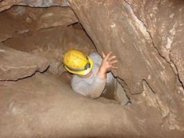
The trail may be narrow, but it's exposed and slippery. And a couple of steep spots make you really grateful that you have opposable thumbs.
The trail is in pretty good shape for a scenic death march. Although going up can be a little scary, coming back down can make you want to sit down and wait for a helicopter. And sliding on your butt a highly common form of locomotion in the steepest spots.
And apparently someone has removed all of the oxygen from the air as you climb higher. Stopping to rest is occasionally interrupted by walking.

Mt. San Jacinto Outdoor Recreation
Hiking, Climbing, Camping, Trail Running, Snowshoeing...
As seen on another forum...
10 posts
• Page 1 of 1
As seen on another forum...
![]() by Hikin_Jim » Thu Aug 16, 2007 9:23 pm
by Hikin_Jim » Thu Aug 16, 2007 9:23 pm
We need this guy to do a write up for Skyline. 
Backpacking stove reviews and information: Adventures In Stoving
Personal hiking blog: Hikin' Jim's Blog
Personal hiking blog: Hikin' Jim's Blog
-

Hikin_Jim - Posts: 4958
- Joined: Mon Oct 30, 2006 9:12 pm
- Location: Orange County, CA
![]() by TRumble24 » Sat Aug 18, 2007 11:00 am
by TRumble24 » Sat Aug 18, 2007 11:00 am
Hilarious!
"You may be a little cold some nights, on mountain tops above the timber-line, but you will see the stars, and by and by you can sleep enough in your town bed, or at least in your grave." - John Muir
-
TRumble24 - Posts: 41
- Joined: Sun Jun 11, 2006 12:15 pm
- Location: Morongo Valley, CA

![]() by Hikin_Jim » Mon Aug 20, 2007 2:57 pm
by Hikin_Jim » Mon Aug 20, 2007 2:57 pm
Walt:
This hike is one of the four primary routes to Mt. Baldy (official name: Mt. San Antonio).
The primary routes are (in order of difficulty):
1. Baldy Notch to Mt. Baldy.
2. Ski Hut Trail to Mt. Baldy.
3. Pine Mtn. to Dawson Pk to Mt. Baldy.
4. Baldy Village to Mt. Baldy (Bear Canyon route)
This route, via Pine Mtn., is the least used route. This route starts from the North on Blue Ridge which is above Wrightwood, CA. If you decide to do this route, be aware that Hwy 138 is closed and that you must use Lone Pine Canyon Rd. to access Wrightwood. See driving directions, here: http://maps.google.com/maps?f=d&hl=en&g ... &z=10&om=1
This route is in remote, relatively untravelled country. You'll see a lot of sheep trails. I have seen more Big Horn Sheep in this area than in any other in Southern California.
As I mentioned, you start on Blue Ridge, here: http://www.topozone.com/map.asp?lat=34. ... &layer=DRG
Then it ascends Pine Mtn, here: http://www.topozone.com/map.asp?lat=34. ... &layer=DRG (you have to do a short bit of off trail to gain the summit).
Then it descends and reascends the next peak, Dawson Pk, here: http://www.topozone.com/map.asp?lat=34. ... &layer=DRG
Now, you're going to really lose some elevation, descending to the saddle between Dawson and Baldy, here: http://www.topozone.com/map.asp?lat=34. ... &layer=DRG The topo shows the trail going slightly East of the saddle. I don't recall that being true. You want to go to the geographic saddle.
From the Dawson-Baldy saddle, you then ascend Mt Baldy, here: http://www.topozone.com/map.asp?lat=34. ... &layer=DRG a Southern Californa 10k+ summit, one of only about 25 total peaks above 10k in S. Cal. The stretch from Dawson-Baldy saddle is quite steep.
This route is "only" 10 miles RT, BUT one has to hike all the way back. Overall, I'd say this is one tough trip although probably not of Skyline's difficulty. One is rewarded with great desert, mountain, and urban views and lots of solitude, particularly mid-week. No water anywhere en route; bring what you'll need.
John Robinson's book, Trails of the Angeles has an excellent write up of the trip.
This hike is one of the four primary routes to Mt. Baldy (official name: Mt. San Antonio).
The primary routes are (in order of difficulty):
1. Baldy Notch to Mt. Baldy.
2. Ski Hut Trail to Mt. Baldy.
3. Pine Mtn. to Dawson Pk to Mt. Baldy.
4. Baldy Village to Mt. Baldy (Bear Canyon route)
This route, via Pine Mtn., is the least used route. This route starts from the North on Blue Ridge which is above Wrightwood, CA. If you decide to do this route, be aware that Hwy 138 is closed and that you must use Lone Pine Canyon Rd. to access Wrightwood. See driving directions, here: http://maps.google.com/maps?f=d&hl=en&g ... &z=10&om=1
This route is in remote, relatively untravelled country. You'll see a lot of sheep trails. I have seen more Big Horn Sheep in this area than in any other in Southern California.
As I mentioned, you start on Blue Ridge, here: http://www.topozone.com/map.asp?lat=34. ... &layer=DRG
Then it ascends Pine Mtn, here: http://www.topozone.com/map.asp?lat=34. ... &layer=DRG (you have to do a short bit of off trail to gain the summit).
Then it descends
Now, you're going to really lose some elevation, descending to the saddle between Dawson and Baldy, here: http://www.topozone.com/map.asp?lat=34. ... &layer=DRG The topo shows the trail going slightly East of the saddle. I don't recall that being true. You want to go to the geographic saddle.
From the Dawson-Baldy saddle, you then ascend Mt Baldy, here: http://www.topozone.com/map.asp?lat=34. ... &layer=DRG a Southern Californa 10k+ summit, one of only about 25 total peaks above 10k in S. Cal. The stretch from Dawson-Baldy saddle is quite steep.
This route is "only" 10 miles RT, BUT one has to hike all the way back. Overall, I'd say this is one tough trip although probably not of Skyline's difficulty. One is rewarded with great desert, mountain, and urban views and lots of solitude, particularly mid-week. No water anywhere en route; bring what you'll need.
John Robinson's book, Trails of the Angeles has an excellent write up of the trip.
Backpacking stove reviews and information: Adventures In Stoving
Personal hiking blog: Hikin' Jim's Blog
Personal hiking blog: Hikin' Jim's Blog
-
Hikin_Jim - Posts: 4958
- Joined: Mon Oct 30, 2006 9:12 pm
- Location: Orange County, CA

![]() by Hikin_Jim » Mon Aug 20, 2007 4:09 pm
by Hikin_Jim » Mon Aug 20, 2007 4:09 pm
Very true. The Acorn trail section is actually a very nice section. It adds about 2 miles each way. There are some nice views en route and a lot of nice, shady areas with beautiful old trees. It also cuts out some mountain driving on dirt roads. Starting at Acorn Canyon saves you about 45 minutes drive time according to Google Maps.
Be aware that the top of Acorn Drive (above approx. the intersection with Finch) is a private road and that parking is for residents only. I don't know that they would tow, but it's probably the right thing to do to respect their wishes. There's a pretty big "no parking" sign, so there must have been a problem (problems) at one point.
There is some water in Acorn Canyon (very very little) as of yesterday afternoon but it's near town, so you might as well just get water in town if you need it.
Jensens Market on the main road in town has an excellent BBQ counter (well, not as good as Walt's, obviously) on the weekends. The little hardware store has a nice but small hiking/sporting goods section.
Backpacking stove reviews and information: Adventures In Stoving
Personal hiking blog: Hikin' Jim's Blog
Personal hiking blog: Hikin' Jim's Blog
-
Hikin_Jim - Posts: 4958
- Joined: Mon Oct 30, 2006 9:12 pm
- Location: Orange County, CA
![]() by Hikin_Jim » Tue Aug 21, 2007 7:47 am
by Hikin_Jim » Tue Aug 21, 2007 7:47 am
Cool. Let us know if you see any sheep.
Backpacking stove reviews and information: Adventures In Stoving
Personal hiking blog: Hikin' Jim's Blog
Personal hiking blog: Hikin' Jim's Blog
-
Hikin_Jim - Posts: 4958
- Joined: Mon Oct 30, 2006 9:12 pm
- Location: Orange County, CA
10 posts
• Page 1 of 1
Return to Mt. San Jacinto & Santa Rosa Mountains
Who is online
Users browsing this forum: Baidu [Spider] and 4 guests