I would appreciate if some of the veteran runners on this site could tell me what are the best trail options in the area. I may be spending some time there in early spring.
Thanks, Chuck

Mt. San Jacinto Outdoor Recreation
Hiking, Climbing, Camping, Trail Running, Snowshoeing...
Trail Running Options in Palm Springs Area
14 posts
• Page 1 of 2 • 1, 2
Trail Running Options in Palm Springs Area
![]() by chuckr » Mon Jan 07, 2013 5:51 pm
by chuckr » Mon Jan 07, 2013 5:51 pm
- chuckr
- Posts: 1
- Joined: Mon Jan 07, 2013 5:49 pm
![]() by cynthia23 » Mon Jan 07, 2013 6:49 pm
by cynthia23 » Mon Jan 07, 2013 6:49 pm
It depends on how much you want to run uphill  Most of the local trails are very vertical. Some amazing people on this board run up trails like Skyline, but that's beyond my imagination.
  However, if your idea of trailrunning means gently rolling terrain with moderate total gain (i.e. 1-3k), I recommend the Art Smith trail. I generally just hike it, but from time to time I shuffle along in something resembling a run. I forget exactly how long it is but I think it's eight to ten miles. It's very pretty and you don't have to deal with snow, either. The trailhead is on Highway 74 in Palm Desert and it goes all the way to either Cathedral City or Palm Springs, where you can either turn around and run back (if you're really energetic) or leave a second car/get picked up. If you want a shorter and more moderate run, I would recommend the South Lykken trail (not the North Lykken) which is about four miles (one way.) There are trailheads at either South Palm Canyon at Murray Canyon Road, or at the end of Mesquite Road. Hope this helps.
Q: How many therapists does it take to screw in a light bulb? A: Only one, but the light bulb has to want to change ...
- cynthia23
- Posts: 1289
- Joined: Tue Nov 07, 2006 3:33 pm
- Location: Rancho Mirage
![]() by Florian » Tue Jan 08, 2013 9:45 am
by Florian » Tue Jan 08, 2013 9:45 am
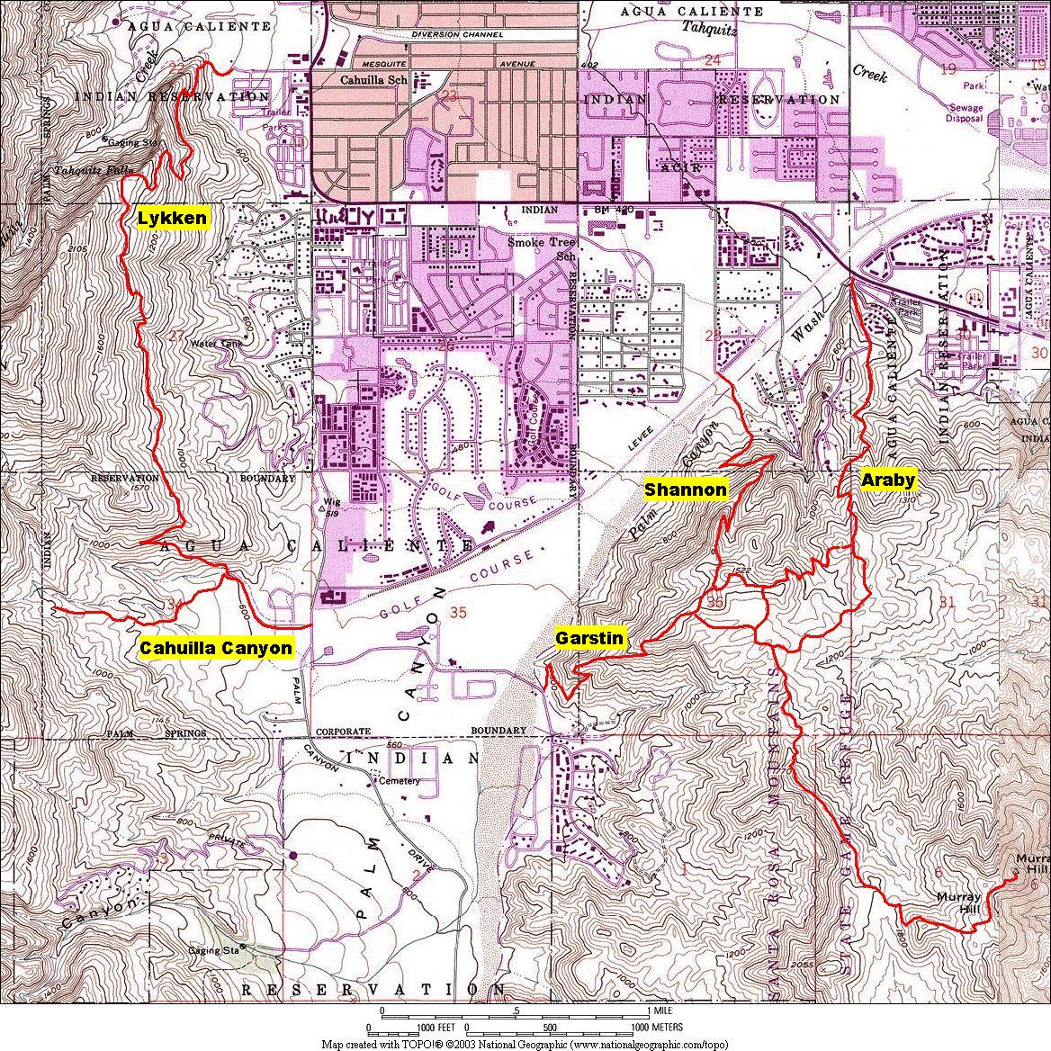
I have a map that shows some of the trails around Palm Springs here ...
http://stargazing.com/trails.jpg
-Florian
http://stargazing.com/trails.jpg
-Florian
-

Florian - Posts: 1441
- Joined: Sat May 16, 2009 4:49 pm
- Location: Palm Springs
![]() by zippetydude » Tue Jan 08, 2013 12:56 pm
by zippetydude » Tue Jan 08, 2013 12:56 pm
Great answers so far. I always recommend, especially in spring, going north out of the Cottonwood trailhead on the PCT. It's about 10 minutes from downtown Palm Springs, so it's not a long drive. It's a beautiful trail and about 4 miles or so in you have a good shot at seeing broad, open meadows covered with green grass and millions of wild flowers.
Another nice route would be to go out Whitewater, again just a few minutes from PS, and go north on the PCT. There is some interesting terrain and some nice wildflowers there as well, although the wildflowers are fewer.
By early spring you might even be able to do some nice loops up top if you take the tram up and cruise around a bit. You'd probably need microspikes as there will be remnant snow, but if there haven't been any recent storms when you come that would probably be sufficient.
If you don't mind driving an hour or so, Joshua Tree has some wonderful places to see also. Hope you have fun!
z
-

zippetydude - Posts: 2751
- Joined: Tue May 09, 2006 5:40 am
![]() by Florian » Tue Jan 08, 2013 6:21 pm
by Florian » Tue Jan 08, 2013 6:21 pm
zippetydude wrote:Great answers so far. I always recommend, especially in spring, going north out of the Cottonwood trailhead on the PCT. It's about 10 minutes from downtown Palm Springs, so it's not a long drive.
Hi Zip. I can't place what trailhead you're referring to here?
-Florian
-
Florian - Posts: 1441
- Joined: Sat May 16, 2009 4:49 pm
- Location: Palm Springs
![]() by zippetydude » Tue Jan 08, 2013 9:57 pm
by zippetydude » Tue Jan 08, 2013 9:57 pm
Hi Florian. I'm still trying to find that contrail pic for you...
Here's a map (if I did it right) that should make it pretty easy to find.
http://maps.google.com/maps?saddr=Hauge ... 6&t=m&z=16
Zoom it a bit and you'll be able to see all the street names easily. I think you're familiar enough with the area for it to be no problem. LMK if you have trouble finding it.
Once you come to the saddle, about 4 miles in, you come across some interesting switchbacks that will lead you down to the flowers. I think March and April are the best times. With all these early storms we've been having, it may be a banner year. I'll start scouting it soon and I'll post if it's coming along nicely.
z
-
zippetydude - Posts: 2751
- Joined: Tue May 09, 2006 5:40 am
![]() by Hikin_Jim » Wed Jan 09, 2013 1:29 am
by Hikin_Jim » Wed Jan 09, 2013 1:29 am
And you're recommending that one proceed east from the Cottonwood PCT trailhead? Or South?
HJ
HJ
Backpacking stove reviews and information: Adventures In Stoving
Personal hiking blog: Hikin' Jim's Blog
Personal hiking blog: Hikin' Jim's Blog
-

Hikin_Jim - Posts: 4958
- Joined: Mon Oct 30, 2006 9:12 pm
- Location: Orange County, CA
![]() by zippetydude » Wed Jan 09, 2013 9:24 pm
by zippetydude » Wed Jan 09, 2013 9:24 pm
Hikin_Jim wrote:And you're recommending that one proceed east from the Cottonwood PCT trailhead? Or South?
HJ
East. It only goes east for about 1/2 mile and then turns mostly north. If you go during a really rainy year, there is a seasonal creek just a few yards from the PCT parking lot that is flowing rather incongrously right through the middle of the desert - it looks totally out of place. You can get to the same wildflower area by going south out of Whitewater, and in truth the distance is probably about the same or maybe even a little less. I was just trying to recommend something where the starting point was close to Palm Springs.
z
-
zippetydude - Posts: 2751
- Joined: Tue May 09, 2006 5:40 am
14 posts
• Page 1 of 2 • 1, 2
Return to Mt. San Jacinto & Santa Rosa Mountains
Who is online
Users browsing this forum: No registered users and 4 guests