Objective: find the last campsite of John Donovan, the PCT hiker who became lost in May 2005 in a once-in-a-lifetime blizzard that struck the mountain, and whose body was found by happenstance one year later by two lost tram-tourists from Texas. The story is fascinating and tragic.
How was he trapped? Was there no way out? His trail, his trials and his ultimate demise is an intense curiosity that cannot be shaken. I want to find that last "impassable area", and then drop this subject all together.
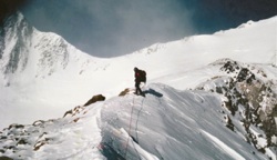
First plan: park near Ramon Street in Palm Springs, enter the mouth of Tahquitz Canyon before sunrise to evade the rangers. On second thought, bad idea. Next plan, park at Humber Park, ascend the Devil Slide Trail, cross the flats to Caramba Camp and make my way down the Tahquitz Creek drainage to the intersection of the Long Valley drainage, then ascend 600 feet up Long Valley and search for the campsite. After studying the Palm Springs and San Jacinto Quadrangle maps, plotting a course on Google Earth, searching the local hiking chat rooms and web sites, I concluded that this was the most effective approach. Packed up the gear: ULA Conduit backpack, free standing tent, fleece and wool layers, long-johns, beanie, two-days food, capacity for 4 liters of water, 20-degree down bag, thermo rest air mattress and z-fold, toiletries, pharmacy/med stuff, maps, compass & whistle, cooking utensils and cell phone. About 25 pounds w/out water. Parked in Humber Park on Wednesday evening and slept in back. Began hiking at 7:00 am Thursday morning and arrived at Caramba Camp around 10:00 am. Sunny and clear with temps in the mid 30s. Breezy with occasional gusts. In other words, perfect.
From Caramba Camp, I descended the Tahquitz drainage for approximately 3.5 miles until the terrain became impassable. The descent down the drainage began on 11/12/2010 at 10:00am. Progress was painfully slow - the canyon proving to be far more difficult than expected, and camp was made at around 4,100 feet at 3:30pm. The sun was heading down and I found a flat rock above creek bed suitable for camping, quite possible the only flat spot available in the entire canyon. My wrists became swollen and sore from leveraging body w/ pack down the boulder-strewn, steep terrain. On numerous occasions my pack had top be removed and lowered by nylon cordage to the landing below, then retrieved after finding a route down. This hike was becoming far more difficult than expected, but returning back up the drainage struck me as a poor option because of the difficulty in ascending the steep drop offs, especially with a pack on. Additionally, the seduction to continue the descent was overwhelming supported by an accompanying rational that an exit would be found below. On two occasions I came upon steep drop offs which, at first, seemed to be insurmountable. At the firs drop off I lowered the backpack, then found a heart-pounding technical climb down. At the second drop off, defeat and surrender seemed inevitable until a rocky outcropping on the south canyon wall caught my attention. Ascending up the way and atop the outcropping, a steep, terra-firma route was found enabling a 'hail Mary' skirting of the falls. But the third drop off, at around 2600 feet, was as remarkable as it is treacherous. The canyon narrowed significantly at this point. On the Agua Caliente quadrangle map, one can observe the horseshoe shaped course way, curving to the north then back again. The steep, granite walls were only 70 feet or so apart, and no safe route down could be found; it was truly impassable. Centuries of cascading water had carved out a resort-like granite slide of approximately 40 or 50 feet, which dropped perhaps 15 feet into a residential-sized pool. The first pool then drained into another shorter slide, which then dropped into to a second, larger pool of water. One option considered was tossing the pack into the water and entering the pool via the slide, but being alone, this seemed far too risky. Additionally, based on what had already been encountered in this treacherous canyon, one could only imagine what else lay below. Thus commenced the option of exiting the canyon via a scramble up the northern wall, ascending 800 feet of terrain of as close to vertical as one might risk climbing without rope and gear, and finding another way to Palm Springs. Once out of the immediate drainage, the intuitive course of action was to take a northerly route, climbing to the upper ridge and then attempt discern an exit route to Palm Springs from the higher vantage point. It was now 3:00 pm and I was out of water. The ridge I was skirting gave way to a south facing slope that was steep and required numerous switchbacks. Fortunately, the sun was already below the ridgeline to the west and the temperature was in the low 70s. After reaching the apex of the slope now being climbed, I was hoping to find a ridgeline that ran east/west and that could be hiked down to Palm Springs, but these ridgelines run north/south and it became evident that no such route existed. What to do? The mountain terrain in this area is steep and riddled with large outcroppings of granite rocks. And the deep drainages all became as treacherous in my imagination as I had encountered in Tahquitz Creek Canyon. It then occurred to me that the Skyline Trail, which runs parallel to Tahquitz Canyon (as well as the other two major drainages, Hidden Fork and Long Valley) is only around 2 to 3 miles from the Tahquitz drainage, and if I stayed on a northerly heading, I would intersect the trail. Around 30 minutes later, I intersected the trail at around 4500 feet. I cannot recall being so relieved to find a trail. Civil twilight was fading by this time and I powered up the headlamp and descended the 6 to 8 or so miles to the intersection of Ramon and La Mirada in Palm Springs, arriving at 8:45pm and waiting for just 15 or so minutes before my wonderful bride of 25 years picked me up. She had 96 ounces of Gatorade with her. The first drink I poured onto the ground, just to say "thank you" to God.
Attempting the Tahquitz drainage was a mistake. I will not do this again. It is far too treacherous and is ultimately impassable unless climbing gear and ropes are taken. Of course, the Indians at the Reservation will not be thrilled with the visit, but an expensive citation is the least of the worries. The canyon is completely choked with debris. In the upper canyon, it is mostly treacherous terrain and steep falls, but at around 4000 feet and below, one encounters hundreds of dead alters, mountain ash, scrub oak and sycamore. It took me 13.5 hours to cover 3.5 miles. (I have been running 80 miles per month on average for the past year). Scratched, bruised and beaten up is most of what the hiker takes away from this verboten hike. From one idiot to another, take a pass on the drainages descending the eastern slopes of the San Jacinto Wilderness. They are dangerous and frustrating, and the wilderness offers far too many superior treks. Skyline Trail, for one, or the loop around the flats for another.
Tahquitz Drainage, Tahquitz Creek, Tahquitz Canyon, Tahquitz Canyon Creek, Tahquitz Canyon Creek Drainage

Mt. San Jacinto Outdoor Recreation
Hiking, Climbing, Camping, Trail Running, Snowshoeing...
Tahquitz Drainage - mission failed
50 posts
• Page 1 of 5 • 1, 2, 3, 4, 5
Tahquitz Drainage - mission failed
![]() by wb » Sun Nov 14, 2010 3:48 am
by wb » Sun Nov 14, 2010 3:48 am
- wb
- Posts: 81
- Joined: Sun Nov 14, 2010 3:41 am
- Location: Orange, CA
![]() by magikwalt » Sun Nov 14, 2010 8:56 am
by magikwalt » Sun Nov 14, 2010 8:56 am
Great trail report on an area I have look at several times. I hiked down from Caramba a ways and found it completely choked. I believe a ridge would be the safer way down but of course you don't get the water supply.
In watching the TV program I Shouldn't Be Alive of the couple from Texas I had difficulty matching pictures and actors behavior with what I know from sectional looks into the area. Using Skyline Trail as a path to probe the drainage I found pretty much what you describe. Staying with the creek becomes impossibly hard unless you have ropes and tape belays.
Any chance you have a gps track of your route?
-

magikwalt - Posts: 766
- Joined: Tue Nov 14, 2006 3:18 pm
- Location: Palm Springs
Tahquitz Drainage - mission failed
![]() by Cy Kaicener » Sun Nov 14, 2010 9:00 am
by Cy Kaicener » Sun Nov 14, 2010 9:00 am
Here are two links by the RMRU describing the terrain that they had go through and some background to the story.
http://www.rmru.org/missions/2006/2006-06-04.html
http://www.rmru.org/missions/2005/2005-017.html
http://www.rmru.org/missions/2006/2006-06-04.html
http://www.rmru.org/missions/2005/2005-017.html
. Please visit my website at www.hiking4health.com for more information especially the Links.
http://cys-hiking-adventures.blogspot.com
http://cys-hiking-adventures.blogspot.com
-

Cy Kaicener - Posts: 2236
- Joined: Tue May 09, 2006 3:50 am
- Location: Rialto, California, USA
![]() by Ulysses » Sun Nov 14, 2010 9:14 am
by Ulysses » Sun Nov 14, 2010 9:14 am
Wow!!! Incredible trip report. Thank you for sharing. Any pictures?
I too have been fascinated by the John Donovan story. I did not, however know that he had decended Tahquitz Canyon via Caramba. I thought he ventured further to the west.
About 30 years ago I was hiking out to Caramba in late spring and encountered 2 beat-up and worn out looking hiker/climbers who claimed they had ascended Tahquitz Canyon. They talked endlessly about the difficulties of the climb. The falls, the pools, the steep walls, and the impassable brush. The beauty of the canyon. I've been intrigued by that canyon every year since, but have never been brave enough to venture below the falls at Carmaba. After reading your account I doubt I ever will.
Interestingly in my older version of John Robinson's guide book he references Snow Creek, Chino Canyon, Tahquitz Canyon, and Andreas Canyon as the "possible" routes up the north face of SJ. Hard to imagine anyone ascending Andreas Canyon.
- Ulysses
- Posts: 279
- Joined: Mon May 03, 2010 6:16 pm
- Location: Idyllwild

![]() by wb » Sun Nov 14, 2010 10:15 am
by wb » Sun Nov 14, 2010 10:15 am
Thank you for the comments. I have been a learner and observer on this web site for some time now, enjoying the reports and information. My treks up Skyline and through the flats were successful, in large part, due to the info found from this group and on this site. The primary motivation for posting the report is to sound the warning to any other hiker who considered exploring the drainages.
Re: John Donovan. Nobody truly knows which drainage he descended. I am reasonably certain, especially now, that he came down Hidden Fork or Long Valley drainages. Once committed, you cannot extract yourself from one and into another, simply because the terrain is impossibly steep and treacherous between them. He probably came down Hidden Fork, which totally blows my mind, really, just because it is *so* steep. However, this was a man who could obviously see the lights of Palm Springs, was stuck in a blizzard and was without cell phone or adequate gear. He was found in Long Valley approximately 600 feet above the Tahquitz Creek merge, and he described being in an "impassable canyon". I have links to all the RSAR reports and a few dozen more, including very informative posts from the PCT-L (which is where I learned of Donovan) and Whiteblaze. Donovan is a text book example of an individual making a series of bad choices while descending into an ominous set of insurmountable topological and environmental factors that ultimately cost him his life. His death just irritates me to no end. The man was less than two miles from the tram, roughly, when making the fateful decision to descend the drainage.
Anyway, I chose to descend down Tahquitz because it appeared to be the least difficult of the three.
I have photos, but have reservations to posting them because this canyon is truly remarkable. The pools, granite falls and water-polished shoots are absolutely beautiful. One views the photos and cannot possibly understand the gravity of the undertaking, and it will be reckless and irresponsible on my part to encourage such a decision. There were three or four occasions where I over my head, and that RSAR entered into the realm of possibilities, but each time, thank God, plan A worked.
My idiocy, however, remains. I still want to find that camp. I understand the treachery of the drainages, and believe that I have located a safe route originating from Skyline. I want to post the route trace (kmz file) of my hike, as well as a potential incursion route to Donovan's last campsite, some time over the next couple of days for comment, suggestion and input.
- wb
- Posts: 81
- Joined: Sun Nov 14, 2010 3:41 am
- Location: Orange, CA
Tahquitz Drainage - mission failed
![]() by neverwashasbeen » Sun Nov 14, 2010 2:34 pm
by neverwashasbeen » Sun Nov 14, 2010 2:34 pm
Thanks for posting such an interesting TR. I have heard tales of the difficulty involved in descending Tahquitz. RMRU used to do it from time to time for training purposes. They said ropes and related gear were required.
The lights of Palm Springs always look so much closer than they really are.
The lights of Palm Springs always look so much closer than they really are.
Happy Trails!
-
neverwashasbeen - Posts: 437
- Joined: Tue May 19, 2009 6:34 am
- Location: Palm Springs
Donovan
![]() by halhiker » Sun Nov 14, 2010 5:14 pm
by halhiker » Sun Nov 14, 2010 5:14 pm
I always figured Donovan went down Long Canyon because the tourists were at the Tram and that the only canyon someone could really access from there. There is a very large waterfall beyond Long View Dome so I figure that's where they got stuck and found the body. Nothing else really makes sense to me.
-

halhiker - Posts: 1260
- Joined: Mon Oct 16, 2006 12:00 pm
- Location: La Quinta, CA
![]() by skunkboy » Mon Nov 15, 2010 1:06 am
by skunkboy » Mon Nov 15, 2010 1:06 am
WB, strong damn work dude! That was one amazing effort, and to do it solo is testament to the stern stuff that you are made of. I know how hard it was cause back in the mid 70's my climbing buddies Mike and Keith and I hiked up Tahquitz canyon to Idyllwild. It is one of those "march or die" kind of experiences that I look back on in wonder now. In high school we had always heard of the seven falls of Tahquitz, and they took on a kind of Shangri-La type mystique in our adolescent minds. My friends and I had been going up there since jr. high and were familar with the first and second falls. In late spring we decided to go explore. We got above the first falls and encountered the naked hippie guys and girls hanging out... literally. (Hey it was the 70's) After talking with them for awhile, we pushed on. Above the 3rd or 4th falls we ran into an old hippie village that was left over from the 60's when the hippies took over Palm Springs in 68 or 69. There was one poor addled soul who was so stoned, he probably thought we were space aliens. We pushed on and spent the night camped out next to the creek. The next morning we continued on and each succeding waterfall became harder and harder to get around. Finally at about 3800 feet, we came to a point where the canyon split. From Acme maps...
http://mapper.acme.com/
it is where Hidden Fork Creek and Tahquitz Creek come together. We realized that we could spend days in those canyons trying to get out, and that there wasn't seven falls in Tahquitz canyon, but rather dozens. Rather than turn around, (which would have been the smart thing) we went straight up the ridge between the two creeks. We spent the next six to eight hours doing the nastiest bushwacking that I have ever done in my life. We ran out of water and spent hours going over, under, and through that nasty shit. We topped out over the ridgeline and found a muddy little trickle that we litteraly stuck our lips into and sucked dry. Shortly after we found the trail to Carumba in the last light of the day, and made our way down to Idylwild in the dark. It is something that I haven't thought about in a long time, and your TR has jogged my Alzheimers encrusted synapses. Thank you for that, and congrats.
Sincerely
Skunk
PS. The largest rattler that I ever saw, was in that canyon. We could hear him from a hundred yards away. I caught a glimpse of him between the bushes and a rock wall. Couldn't tell how long he was, but he looked as thick as my leg.
-

skunkboy - Posts: 108
- Joined: Mon Mar 29, 2010 11:05 am
- Location: Yucca Valley

50 posts
• Page 1 of 5 • 1, 2, 3, 4, 5
Return to Mt. San Jacinto & Santa Rosa Mountains
Who is online
Users browsing this forum: No registered users and 6 guests