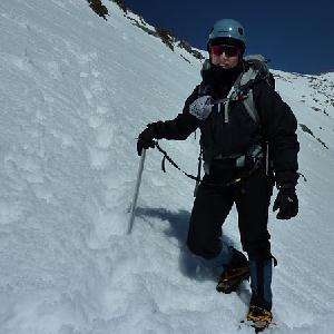
From this point on, it became a little bit of a physical struggle with the altitude and elevation gain. The trail was getting steeper and steeper.
We continued up slowly. The steep sections were a little tricky for us snowshoe rookies. The hard pack wasn’t too bad. Our Denali Evo Ascents worked great, especially with the elevators, but the slushy & icey stuff got a little slick. We were pretty much exhausted and were stopping to catch our breath about every 40-50 feet. The temperature was in the high 50’s-low 60’s and we were dressed for cooler weather. Needless to say, I was sweating like a pig…as usual! During one of these stops, we met up with Stan aka zippetydude. Nice to meet you Stan and thanks for the invite this summer. He told us that the worst part was almost over and we only had a little over 100 yards of elevation and about half a mile or so to the summit. This was good news for us weary travelers! We continued up to Miller Peak where we stopped to take a rest and eat our PB & J sandwiches which tasted pretty darn good above 10K!!!!
After lunch and a scramble to the top of Miller for pictures, we hit the trail again…up up up with me leading the final push, well not leading, just walking in front of Curt..lol!
We were both having some minor problems with the altitude, which is pretty common when you leave sea level at 6am and you’re above 10,000ft by 1pm. We talked about turning around but neither one of us wanted to give up, so we plodded on. We would pick a tree or rock and say, “push it to that tree, stop & breathe, now to that rock, stop & breathe.” We kept this up for a little while and I noticed Curt was stopping more frequently, so I waited for him and asked how he was feeling. He said, “like crap!” I asked if he wanted to call it a day and turn around. I told him I was totally OK with that. He didn’t answer right away, so I checked my GPS and realized that we were almost at 10,700 ft.
When I told him this, he said, “let’s keep going…if we stop now it would be a failure.” Well we made it to the top at about 1:30pm. Yes, 5 hours to hike 2.8 miles with a 2300 ft elevation gain…pathetic, but we made it! t was so clear, we could see San Gorgonio, Mt Baldy, and Catalina…WOW it was beautiful up there. We spent about 30 minutes taking pictures and admiring the view. There was another couple up there who had hiked to the peak in the summer and they said we were probably standing on 13’-14’ feet of snow. We never saw the ski hut, so we didn’t sign the register…I was bummed. I wanted to dedicate this hike to my friend Laura Molnar. Her hiking and climbing accomplishments have motivated me in many ways and she is always there to answer a gear question or give me info about a trail we’re planning to hike. Thank you Laura, San J was for you!
As we geared up to start heading back, we reminded each other to take it slow and be careful because it was going to be steep heading down. We gave it our best shot with the snowshoes, but after both of us fell a few times on the slush and ice it was clear that the shoes had to go. We opted for crampons over microspikes for the grip factor, and our new G10’s worked perfectly! After that, the hike back to the ranger station was pretty nice until the camping area where we had to stop again and switch to the Kahtoolas. We made it to the ranger station at 4:30pm. An amazing 8 hours to hike 5.6 miles…I still think my GPS is off on the distance, my legs said that we went a lot further

We had to wait over an hour and a half for the next available tram…that sucks what you’re tired and hungry. Of course, we got stuck behind the most obnoxious group of drunks drinking brandy and tequila shots while they waited in line. When we finally moved to the last loading area, all hell broke loose after someone complained about the drunks. One of the women got belligerent with the rangers so they handcuffed her. She resisted and started screaming, so they put her on the ground. Then her husband starts in with the rangers, so they cuffed him. Meanwhile, our tram was pulling in and we were finally loading. Once we were all in the tram, the doors opened back up and there was a ranger with the two handcuffed drunks. The ranger boarded and said, “I’m sorry, you will have to exit and wait for the next tram. These people have to be taken down in an empty car”
I’ll refrain from using the actual expletives, but that was it for me. I started spouting off to the ranger and tram operator. “You’ve got to be <bleepin'> kidding me! No freakin’ way am I waiting for another tram…” Curt yelled, “those <bleepin'> idiots can walk down or ride on top of the damn car!” That got our group riled up, so they left us on the tram and made the drunks wait!
I apologized to the tram operator who understood completely. Several people actually thanked us for speaking up…that was nice. For the ride down, the operator turned off the lights and played some old Journey tunes…very cool!
All in all it was an AWESOME day.
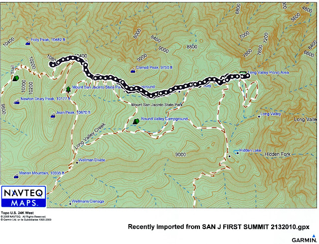
Can anyone tell me if we were travelling up the Sid Davis?
PICTURES ARE HERE http://picasaweb.google.com/BiletChick/SANJACINTOFIRSTSUMMIT21310#