memorial weekend 2013 met hikin Jim and entourage on PCT segment between hwy 74 and Idyllwild.
Flora/Fauna
http://www.flickr.com/photos/v8flickr/sets/72157634398671808/
Rock
http://www.flickr.com/photos/v8flickr/sets/72157634398560998/
more words and pix to come.

Mt. San Jacinto Outdoor Recreation
Hiking, Climbing, Camping, Trail Running, Snowshoeing...
PCT: 74-Idyllwild pix
18 posts
• Page 1 of 2 • 1, 2
PCT: 74-Idyllwild pix
![]() by HH8 » Sat Jun 29, 2013 3:11 pm
by HH8 » Sat Jun 29, 2013 3:11 pm
- HH8
- Posts: 529
- Joined: Wed Aug 10, 2011 8:30 am
- Location: San Diego
Re: PCT: 74-Idyllwild pix
![]() by Hikin_Jim » Thu Jul 04, 2013 12:17 pm
by Hikin_Jim » Thu Jul 04, 2013 12:17 pm
Yes, the usual: press secretary, massage therapist, cook, wardrobe assistant, etc. Travel light I always say.HH8 wrote:memorial weekend 2013 met hikin Jim and entourage on PCT segment between hwy 74 and Idyllwild.
HJ
Backpacking stove reviews and information: Adventures In Stoving
Personal hiking blog: Hikin' Jim's Blog
Personal hiking blog: Hikin' Jim's Blog
-

Hikin_Jim - Posts: 4958
- Joined: Mon Oct 30, 2006 9:12 pm
- Location: Orange County, CA
Re: PCT: 74-Idyllwild pix
![]() by HH8 » Thu Jul 04, 2013 2:01 pm
by HH8 » Thu Jul 04, 2013 2:01 pm
HH8 wrote:more words and pix to come.
As promised:
My TR includes signs, water, camps, views and humor. Click on any photo to get more info from my Flickr descriptions.
Memorial Weekend (5/26/13) we did the segment of Pacific Crest Trail from 74 (Palms to Pines Hwy) to Idyllwild (about 25 miles, over 4000 feet elevation).


Signs
Signage appeared in varying styles and conditions,


sometimes with comments added, but never exactly matching the GPS. Since when are North and South at right angles?!


Rots O Ruck, peoples!


Water
Water sources were most critical this trip. At Cedar Springs I actually pumped up-trickle from the trough.


From Fobes junction on the PCT we see the zigzags down to water by the ranch

Generous genius Halhiker , from Apple Canyon, shlepped and stashed 3 gallons for Hikin Jim at that junction, which his group graciously shared with us.

Altho it was protected from sun and scroungers by log and leaf, jfr located Hal’s nectar of life, to the relief of all.


Camps
We noted several campable sites. Click on photo for location info.


This one looked like a perfect spot for my bedroll, but under a few oak leaves was non-buried diarrhea.
With the nearest extra water for washing so many miles distant, it a less than pleasant discovery.

Views
The terrain was sometimes desert,

sometimes flowered, sometimes dappled protection from the evil day star.


There were switchbacks


and a pointless gate without any fence.

Most of it was well-maintained (after each washout)


but trails can degrade suddenly

Humor
This is where Hikin Jim (pink dot) & co startled a snake down to our switchback

Jim scaled Ansell Rock (horizon, left) while we finally ate breakfast here at 3 PM

This crocodile was lurking near Apache

All other pines marched up to pay respects to the arboreal King of the Hill

And of course (why we do it) the crest views:
my 30 favorite PCT views
- HH8
- Posts: 529
- Joined: Wed Aug 10, 2011 8:30 am
- Location: San Diego
![]() by arocknoid » Sat Jul 06, 2013 8:58 am
by arocknoid » Sat Jul 06, 2013 8:58 am
Thanks for the entertaining and edifying TR, HH8.
Appreciate the dry humor, as well as the overlay of apophenia.
(plus the pareidolia of the crocodilia!):
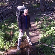
That pack is Owd Skoo', bigtime; I have one just like it for which I just replaced a couple of the clevis pins which finally bent under the accumulation of weight-bearing years. Shoulder straps and belt/HW are the only things which really benefit from "newer/better" design and materials, but hey.
Veddy nice of Hal to cache H20:
Jim was hiking with Tom Skerritt's nephew--a terrific crew to meet up, looks like:
Thanks for all the *content* as well (though flickr's New Format is not improved , incl. dredging out add'l info)
kind regards,
arocknoid
Appreciate the dry humor, as well as the overlay of apophenia.
(plus the pareidolia of the crocodilia!):
That pack is Owd Skoo', bigtime; I have one just like it for which I just replaced a couple of the clevis pins which finally bent under the accumulation of weight-bearing years. Shoulder straps and belt/HW are the only things which really benefit from "newer/better" design and materials, but hey.
Veddy nice of Hal to cache H20:
Jim was hiking with Tom Skerritt's nephew--a terrific crew to meet up, looks like:
Thanks for all the *content* as well (though flickr's New Format is not improved , incl. dredging out add'l info)
kind regards,
arocknoid
-

arocknoid - Posts: 342
- Joined: Thu Aug 26, 2010 11:36 pm

![]() by HH8 » Sun Jul 07, 2013 8:20 am
by HH8 » Sun Jul 07, 2013 8:20 am
arocknoid wrote:Appreciate the dry humor, as well as the overlay of apophenia.
(plus the pareidolia of the crocodilia!):
Ah ha ha! You made me look, but my dictionary didn't include
a-pop-hen-ia. Pa-reid-o-lia (giddy up Lia! - that visual is holding) was dead on.
That pack ... straps and belt/HW are the only things which really benefit from "newer/better" design and materials, but hey.
30 years ago it was navy blue. In Banff last summer it got some temporary belt mods:

Veddy nice of Hal to cache H20:--a terrific crew to meet up
Couldna say it better me-sel'
- HH8
- Posts: 529
- Joined: Wed Aug 10, 2011 8:30 am
- Location: San Diego
![]() by jfr » Sun Jul 07, 2013 10:45 am
by jfr » Sun Jul 07, 2013 10:45 am
arocknoid wrote:That pack is Owd Skoo', bigtime; I have one just like it for which I just replaced a couple of the clevis pins which finally bent under the accumulation of weight-bearing years. Shoulder straps and belt/HW are the only things which really benefit from "newer/better" design and materials, but hey.
Those blue nylon add-ons on the hipbelt (above) contain pieces of "gel" from a keyboard wrist-rest, and were carefully sewn on to precisely cover my hipbones where all the weight of the pack seems to rest. I have essentially zero subcutaneous fat on my hipbones, and on long, multiple-day treks the original hipbelt used to break my skin (I'd bleed, but not much due to the constant pressure), and the next morning I'd hoist that pack back on and grimace with pain as the weight bore down on the scabs. Ouch! Hiking all day in pain only makes for a good story, not a good day. Hooray for gel!
HH8 wrote:30 years ago it was navy blue.
More like 40 years ago! But who's counting?
There's a brother to my pack in the historical section of the Camp Trails web site: http://www.camptrails.eu/k/photocategories2/History
But mine's seen just a few more miles and hours in the sun than that "like-new" museum piece!

-
jfr - Posts: 145
- Joined: Sun Jul 12, 2009 11:10 am
- Location: 32N 117W
![]() by Ellen » Mon Jul 08, 2013 7:38 am
by Ellen » Mon Jul 08, 2013 7:38 am
Howdy JFR 
Holy Cow, you still have and use a Camptrails? That was my first backpack purchased from Gemco in 1972. Should've hung onto it for posterity
Howdy 'Noid
I love reading the board to improve my vocabulary -- excuse me while I go look up apophenia and pareidolia
Miles of smiles,
Ellen
Holy Cow, you still have and use a Camptrails? That was my first backpack purchased from Gemco in 1972. Should've hung onto it for posterity
Howdy 'Noid
I love reading the board to improve my vocabulary -- excuse me while I go look up apophenia and pareidolia
Miles of smiles,
Ellen
- Ellen
- Posts: 2578
- Joined: Thu Mar 29, 2007 9:38 am
- Location: Riverside, CA
![]() by Hikin_Jim » Mon Jul 08, 2013 6:36 pm
by Hikin_Jim » Mon Jul 08, 2013 6:36 pm
Good stuff, and thanks for the creative way of thanking humble Hal who acted like packing 3 gallons of life saving water for us was no big deal.
jfr, one of these days we've got to get you an internal frame pack. At least for me, no more sore hips.
HJ
jfr, one of these days we've got to get you an internal frame pack. At least for me, no more sore hips.
HJ
Backpacking stove reviews and information: Adventures In Stoving
Personal hiking blog: Hikin' Jim's Blog
Personal hiking blog: Hikin' Jim's Blog
-
Hikin_Jim - Posts: 4958
- Joined: Mon Oct 30, 2006 9:12 pm
- Location: Orange County, CA
18 posts
• Page 1 of 2 • 1, 2
Return to Mt. San Jacinto & Santa Rosa Mountains
Who is online
Users browsing this forum: No registered users and 4 guests