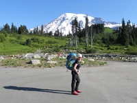
lights from hikers going up Skyline at 1,500 ft, mostly members of SJHC

I didnt want to be caught in the ginormous group so I quickened my pace, hoping to run into some smaller groups further up the trail. At around 2,000 ft I ran into Mike who was hiking solo. We ended up hiking together for the rest of the Skyline portion.
view from 3,500 ft

I was surprised that the temperature remained fairly constant for much of the hike up. Even at sunrise at flat rock, it still felt like high 50s.


heading up the last portion of Skyline, at ~8,000ft the temperature suddenly plummeted from high 50s into low 30s


Soon we were up at Grubs Notch at around 8. Mike had completed his first ever Skyline. We headed over to the ranger station to fill out permits and eat a snack. I filled 2 liters of water in the bathrooms. It tasted horrible, but it was still water. After 20 minutes at the ranger station, we started hiking up. Half a mile after the ranger station, I headed off trail towards my first 2 peaks, Luella Todd and Divide Peaks. Mike continued towards San Jacinto Peak.
Divide Peak- the summit block looks like a bird spreading its wings

The initial off trail was steep and rocky, but then it flattened out in a gradual uphill slope. After 15 minutes I was at the base of the rockpile of Luella Todd Peak. I dropped my pack and headed up. I was glad to see sunlight up ahead. There was a big register at the top lodged in a crack between two rocks.


Several rockpiles rose up to the east in the direction of Divide Peak, but I didnt know which one was the actual highpoint. I descended the Luella Todd rockpile and climbed the next one over. Nope. I climbed two more rockpiles as I kept heading east. At the top of each of them, another rockpile rose up higher towards the east. Finally, I saw one that HAD to be the highpoint. There was nothing higher behind it. It turned out that it was. I scouted around to find a summit register, but there was none. The views were pretty good.


the actual highpoint of Divide Peak

views from Divide Peak summit


I descended the rockpile and retraced my steps back to where I dropped the pack below Luella Todd Peak. I descended back down to the trail and headed towards Wellmans Junction. The trail was very busy. Many people had taken advantage of the good weather. I reached Wellmans at around 11am. There were about 20 people there. I sat down and ate lunch which consisted of 3 tangerines, veggie sticks, a clif bar, and some nuts. After lunch, I left the trail and started ascending towards Marion Mountain. Almost immediately after I left the trail, low, thorny bushes covered the ground and it was getting very hard to walk without getting scratched. Heading up was slow going as the amount and density of the bushes increased. My initial route was to traverse along the east side of the Marion-Jean-Jacinto ridge and slowly ascend to Marion. But when I looked across the traverse, it was covered with more of those thorny bushes and would take way to long. I decided to go straight up to Jean Peak and walk to Marion along the ridge, which would be free of bushes. The brush really increased right below Jean Peak. I aimed for rocks whenever they would appear. After 30 minutes I was at Jean Peak. I dropped my pack and continued south towards Marion. I was relived to see that the route was easy going and free of bushes. The traverse was straight forward, skirting the west side of a small bump on the ridge.
views of Tauquitz Peak while ascending to Jean


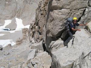
The summit block of Marion was probably my favorite that day. Just as I was about to get to it, a hiker who was also doing the same peak walked out of the trees. He showed me a fun class 3 crack on the north side of the summit block that had to be climbed to get to the top of it. Views were also pretty good from this peak. I could see the rest of the traverse up to San Jacinto Peak.

view towards Gorgonio

Tauquitz Peak

I left Marion at 12pm and headed back towards Jean. The other hiker was also planning on doing the same traverse over to Jean Peak. He stayed a little longer on Marion while I started headed down. I had not slept the previous night and started feeling my eyes get heavy. I felt better halfway though the traverse and picked up the pace. Soon I was back at Jean Peak and gathered up the pack.
Marion from Jean

San Jacinto Peak

The traverse over to San Jacinto Peak was pretty nice. There were great views and some easy rocky terrain. I arrived at the summit to find most of the C2C group there. They had been there for about 40 minutes waiting for the remaining 5 people in the group. We chatted and I ate some veggie sticks. Some people in the group had subway sandwiches!

the crowded summit

20 minutes later, everyone in the group had gotten to the summit. We cheered and took some pictures before heading down. Perry led the group down on one of his shortcuts. I saw Miller Peak on the way down and decided to tag it really quick.
Miller Peak summit block, note the plaques at the top

view east from Miller

south- that yellow thingy down there is round valley

north towards Gorgonio

San Jacinto Peak

I descended Miller and caught up with the rest of the group just as they were turning at the cutoff to the Jim Davis shortcut.

I chatted with Perry and Mihai as we descended the Jim Davis trail. There was the usual routefinding to locate Tamarack valley which went without a hitch. We got back to the Long Valley ranger station at around 3:20pm. Greg had hiked down earlier and was waiting for there. Everyone else was planning on taking the tram down, but he wanted to hike back down to the museum. I was still feeling pretty good so I decided to join him. We headed up towards the tram station to see if Sung wanted to join is. It turned out she did, as she had never done this before. I emptied out my bottles of disgusting bathroom water and filled up at the drinking fountains. It looked like Sung had the same opinions about the water as she was doing the same. Greg told us he would meet us at the bottom of the ramp when we were finished. He ran back to to the ranger station to retrieve the hiking poles he accidentally left there. 15 minutes later, the three us were on the trail heading towards Grubs notch.
The descent of skyline was nice. A cool breeze was sweeping up the canyons. We ran into 4 other hikers at Coffmans Crag. They were the last people we saw on the trail that day. Views were really nice because of the time of the day.


We took a short break at flat rock. Greg pulled out a sandwich, I had a muffin, and Sung nibbled on some cheese. Before I finished the muffin, we were packing up and on the trail again.


The flashlights were out at 4,000 ft as we started slipping and sliding. We listened to a concert in Palm Springs all the way down the mountain. As was the last few times I had done this, the last part of skyline below 4,000 ft seemed to take forever. The city looks close but never gets closer. As we reached rescue box #1 I knew we still had about an hour at the pace we were going. We couldnt go too fast as the terrain started getting rockier. At one point, Greg surprised a bird which suddenly jumped up 2 feet in front of him, making all three of us jump. At last, we could see the parking lot of the museum and after 10 minutes we were back at the trailhead. An end to an amazing day.