Marion Mountain, PCT, and Deer Springs Trails - Water Report

General Palm Springs area.

Marion Mountain, PCT, and Deer Springs Trails - Water Report

Postby Hikin_Jim » Sun Nov 18, 2012 9:47 pm

I ascended Newton Drury Peak via the Marion Mountain, PCT, and Deer Springs Trails on Friday, November 16th. This was a really fun hike for me since I this was the last peak for me to climb of all the twenty three peaks over 10,000' in Southern California.

I'll write something up more extensive soon, but for now I thought I'd do a quick water report. Referring to the points marked in the above map link:
C -- There is no water available at the Spring marked at point "C". There's a structure built over the spring with a pipe leading out of it which I assume brings water to the Marion Mountain Campground. There was a hose there, but I didn't see a way to get water. I didn't spend a lot of time checking though since this is near the start of the hike and both my bottles were still pretty full.
Image
D -- Small creek bed, dry.
E -- Small creek bed, dry.
F -- Small creek bed, dry.
G -- Small creek bed, dry.
H -- "Deer Springs." Actually, the springs are located higher up on the mountain and this is the creek that flows down from the springs, but everyone calls this area Deer Springs. Plenty of water here on 11/16/2012. This incidentally is the North Fork of the San Jacinto River and is one of the top two most reliable water sources on this route.
Image
Image
I -- Another branch of the North Fork of the San Jacinto River. This is the other of the top two most reliable sources of water on this route. I've seen this branch have water when Deer Springs was completely dry.
Image
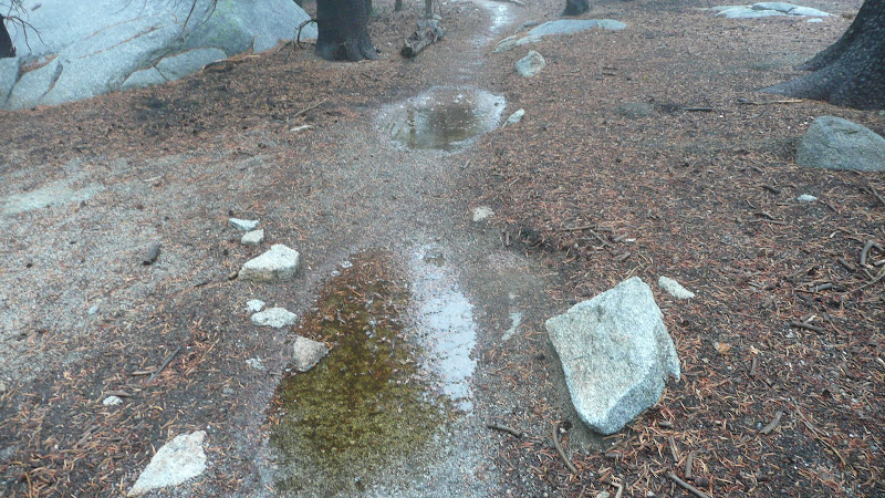
J -- Small creek, barely flowing on 11/16/2012.
Image
K -- Small creek, flowing well on 11/16/2012.
Image
L -- Creek crossing below Little Round Valley. This is usually the best spot in LRV to collect water, but it was completely dry on 11/16/2012.
Image
M -- The meadow in LRV. Completely dry 11/16/2012.
Image

HJ
Backpacking stove reviews and information:  Adventures In Stoving
Personal hiking blog: Hikin' Jim's Blog
User avatar
Hikin_Jim
 
Posts: 4958
Joined: Mon Oct 30, 2006 9:12 pm
Location: Orange County, CA

Postby Ulysses » Mon Nov 19, 2012 5:22 pm

Thanks for posting Jim. Very helpful. I went through Little Round Valley in Sept. and it was just barely flowing. Have been wondering what it was like up there.
Ulysses
 
Posts: 279
Joined: Mon May 03, 2010 6:16 pm
Location: Idyllwild

Postby Hikin_Jim » Mon Nov 19, 2012 6:16 pm

You're welcome. I had heard there wasn't much water left in LRV, but I was a bit surprised that it was bone dry, particularly since even the smaller sources along the Deer Springs Trail were still flowing.

By the time I left, there was a little bit of water in LRV, but that was just pooling from the rain. I wouldn't count on water there right now.
Image

Heck, even the trail itself was ponding up, but again, that's short lived, and I wouldn't count on it.

Image

HJ
Backpacking stove reviews and information:  Adventures In Stoving
Personal hiking blog: Hikin' Jim's Blog
User avatar
Hikin_Jim
 
Posts: 4958
Joined: Mon Oct 30, 2006 9:12 pm
Location: Orange County, CA

Postby WOLFDOG » Tue Nov 27, 2012 5:25 pm

Just a manner of limited time before the snow arrives, great pictures
Jon Braginton
User avatar
WOLFDOG
 
Posts: 45
Joined: Sat Mar 08, 2008 11:20 am
Location: La Quinta

Postby Hikin_Jim » Tue Nov 27, 2012 5:36 pm

Yep. Maybe as soon as tomorrow night or Thursday.

HJ
Backpacking stove reviews and information:  Adventures In Stoving
Personal hiking blog: Hikin' Jim's Blog
User avatar
Hikin_Jim
 
Posts: 4958
Joined: Mon Oct 30, 2006 9:12 pm
Location: Orange County, CA


Return to Mt. San Jacinto & Santa Rosa Mountains

Who is online

Users browsing this forum: Google [Bot] and 6 guests